Areas of fog for Thursday morning, partly cloudy with more snow arriving Friday
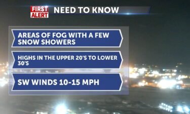
A few isolated snow showers for Wednesday night into Thursday, with some fog development as the winds relax a bit overnight. Overnight, mostly cloudy…
Continue Reading A few isolated snow showers for Wednesday night into Thursday, with some fog development as the winds relax a bit overnight. Overnight, mostly cloudy…
Continue Reading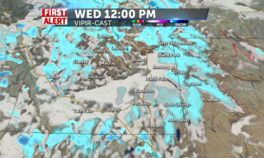
Stray valley snow showers and isolated mountain snow showers will be across the region today with mostly cloudy…
Continue Reading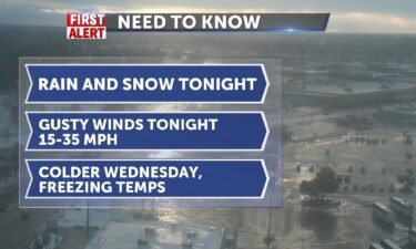
A cold front moving through will lower snow levels overnight with gusty winds. We’ll see a few snow showers for Wednesday, mostly into the…
Continue Reading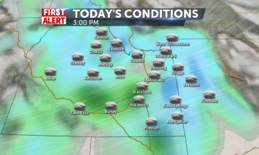
Scattered valley rain showers and mountain snow showers will be found throughout the entire day on…
Continue Reading
(FIRST ALERT WEATHER) – A parade of storms with an atmospheric river, delivering a mix of precipitation and warmer temperatures. For Tuesday we have…
Continue Reading Rain, snow, gusty winds with several storms this week A parade of storms with an atmospheric river, delivering a mix of precipitation and warmer…
Continue Reading
Foggy conditions will be across most of the region for the morning hours followed by some patchy fog and cloudy skies for the…
Continue Reading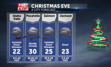
Isolated rounds of freezing rain and snow showers are expected to be around for much of the day with everyone having about a 20-30% chance of getting…
Continue Reading
For Christmas Eve, mostly cloudy skies will be across the region with dry conditions during the day and snow showers late at…
Continue Reading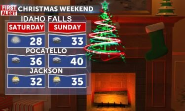
Snow showers along with a warmer day today, if 18-23 is warm? N winds 10mph with sharp wind chills at times. Our snow chances for the valley at…
Continue Reading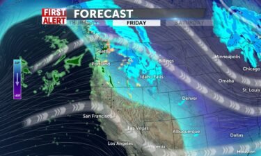
We have another round of Pacific moisture on the move for this Friday and Saturday. Overnight, mostly cloudy with a low of -5°. Light winds around…
Continue Reading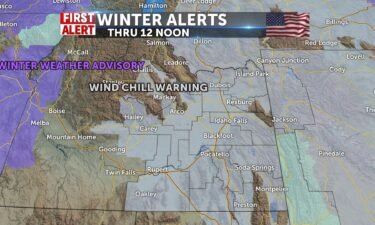
This blast of arctic air and a wind chill warning make it dangerously cold today and into tonight before some snow shows up tomorrow and warms things…
Continue Reading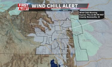
Expect frigid conditions and dangerous wind chills from a cold front leaving the area. Overnight, we’ll see areas of blowing snow. Mostly…
Continue Reading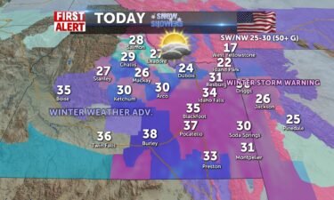
Wild winds at 70mph reported this morning near ID/WY state line causing whiteout and blizzard like conditions closing 26, 32, 33 ahead of a major…
Continue Reading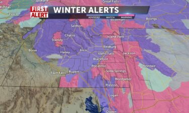
A cold front will move through the area tonight into Wednesday morning. Light to moderate snow will develop behind the cold front tonight and…
Continue Reading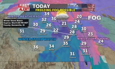
We’ll be warmer (lol) and in the 20’s and 30’s for today and tomorrow as we storm up with some 1-3″ of snow for Idaho Falls possible into tomorrow…
Continue Reading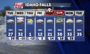
A stormy weather pattern arrives for Tuesday and Wednesday. We’ll see temps warming slightly with scattered mountain snow Tuesday and more…
Continue Reading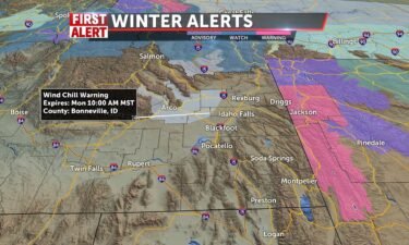
ARCO/MUD LAKE DESERT-LOST RIVER VALLEY- INCLUDING THE CITIES OF MUD LAKE, INL, CRATERS OF THE MOON NM, HOWE, ARCO, MACKAY, AND CHILLY …WIND CHILL…
Continue Reading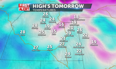
Mostly cloudy skies are expected with more snow flurries on the way for our local…
Continue Reading
High pressure with a temperature inversion will remain in place this Saturday. We’ll start to move some of this cloud cover Sunday. Cold overnight…
Continue Reading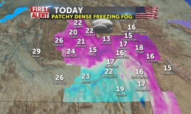
We been invaded by cold air and high pressure on top of the area keeps clouds in the valley. Patchy freezing dense fog remains our big weather story…
Continue Reading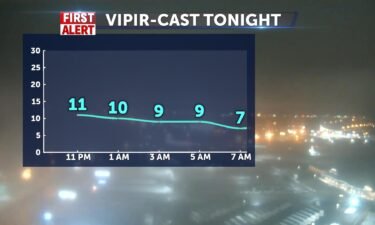
We have a cold, northerly upper-level flow, keeping our temperatures well below normal. Overnight, Patchy freezing fog in the Snake River Plain, with…
Continue Reading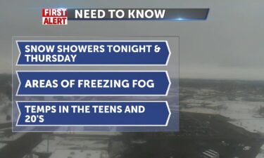
Scattered snow showers tonight, as a system moves down along the jet stream. A chance of snow with areas of Patchy freezing fog. Cloudy, with a low…
Continue Reading
Partly cloudy for Tuesday afternoon with a few areas of cloud cover. We are still are seeing some light snowfall for our Tuesday with freezing fog…
Continue Reading
That snowy low eases east and we’ll see some clearing later. Light winds and clouds off and on with freezing fog for our mornings, with some light…
Continue Reading
An area of low-pressure overhead is delivering some snow tonight and early Tuesday. As this low moves east, we’ll pull in cold air from the north.…
Continue Reading
Avalanche warning for the Bear River Range issued this morning AVALANCHE WARNING. VERY DANGEROUS AVALANCHE CONDITIONS EXIST AND THE AVALANCHE DANGER…
Continue Reading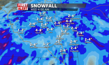
Isolated snow showers will be with us for all of…
Continue Reading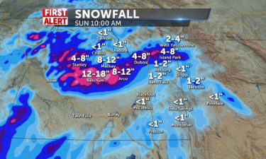
Scattered snow showers will be over the entire region especially in the morning on…
Continue Reading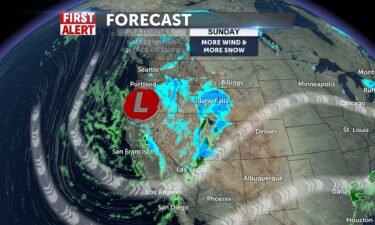
A large system will move through this weekend. We’re expecting to see heavy snow in our mountains, with some acclamations in the Snake River Plain.…
Continue Reading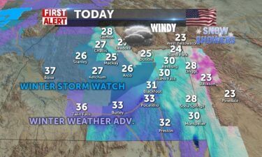
First round of snow this morning sets us up for a frozen layer of slush ahead of low clouds of freezing fog and more showers. Our biggest snows come…
Continue Reading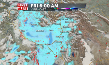
Scattered snow showers will be across the entire region for the morning hours before slowly clearing things up in the…
Continue Reading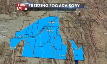
Freezing fog advisory ahead of the morning commute for lower valley along I-15 and into Bear River range as well. This was last until mid-morning. We…
Continue Reading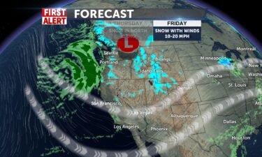
Light winds and freezing temperatures, will allow for more fog formation overnight into Thursday. Overnight lows around 13°, with winds at 5 mph.…
Continue Reading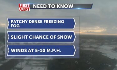
Overnight, areas of patchy dense freezing fog. Mostly cloudy with a low around 18° and light winds at 5 mph. Wednesday, a slight chance of snow with…
Continue Reading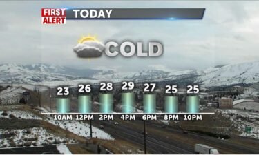
Low clouds and visibility issues make for a slow ride this morning. Freezing fog makes some roads slick in addition to your windshield. Cloudy and…
Continue Reading
We’ll sit with cold freezing temps for Tuesday and Wednesday with areas of overnight and morning fog. We’ll have a slight chance from the fog and…
Continue Reading
Isolated snow showers will be with us in our local mountains for Monday with a stray snow shower or two going into the…
Continue Reading
Snow showers will be widespread tomorrow across the region starting early in the morning and continuing throughout the day into the…
Continue Reading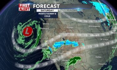
Cold temperatures late Friday and Saturday, with sub-zero wind chills. A few flurries with winds around 5-10 mph. Saturday, mostly sunny, with a high…
Continue Reading
As the overnight storm moves out, cold air and SW winds 10-20 mph lock down the temperatures with single digit and below zero wind chills. Highs…
Continue Reading
Heavy snow showers are across the all of our local mountains and we are expecting a good round of heavy snow to go through the valleys later in the…
Continue Reading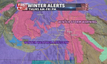
Idaho Falls, Rexburg, St. Anthony, Pocatello, Blackfoot, American Falls, Shelley, Fort Hall, Burley, Rupert, Heyburn, Oakley, Albion, Almo, Malta,…
Continue Reading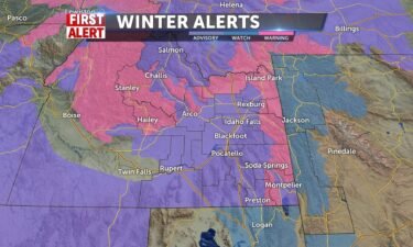
WINTER WEATHER ADVISORY REMAINS IN EFFECT FROM 5 AM THURSDAYTO 5 PM MST FRIDAY… WHAT…Snow expected. Total snow accumulations of 5 to 12inches,…
Continue Reading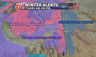
Warmer today with windy snow showers affecting outlying areas this morning, highs will be around freezing in the valley. 20’s for mountains with snow…
Continue Reading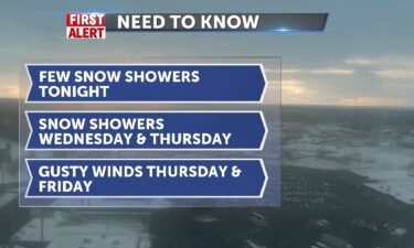
Tuesday night, a chance of snow with cloudy skies. A low around the mid to upper teens. For Wednesday, we’ll see a chance of snow with cloudy skies…
Continue Reading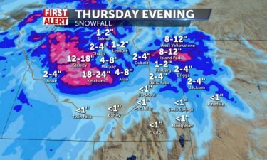
Cold air and some leftover showers this morning make things ultra cold with wind chills below zero or single digits. Winds today from the…
Continue Reading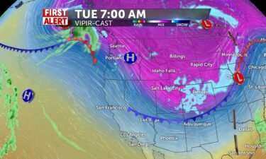
We have one system exiting the region, with another moving down from the northwest this week. A few snow showers Monday night, with areas of Freezing…
Continue Reading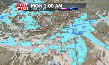
Snow showers are expected across the majority of the region tonight and they should continue into the overnight and early morning…
Continue Reading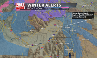
Mostly cloudy to completely cloudy skies will be with us for most of the day Sunday with snow showers returning…
Continue Reading
A quick blast of winter weather overnight tonight and lingering through early afternoon for the eastern highlands and western Wyoming will be the…
Continue Reading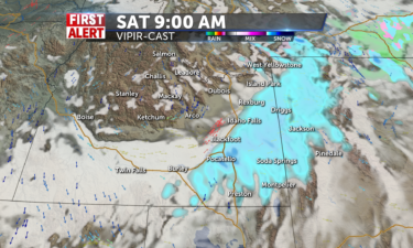
Mostly sunny to partly cloudy conditions are expected across the region today with no chances for any snow…
Continue Reading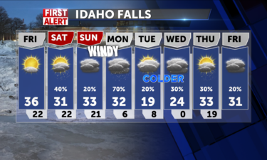
Partly to mostly cloudy conditions are expected for Black Friday with no snow showers within the…
Continue Reading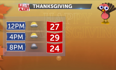
Partly cloudy skies will be across the region for today on Thanksgiving. There are no chances for any snow…
Continue Reading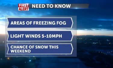
High pressure moving in from the south will allow for drier conditions and areas of freezing fog. Wednesday night and Thursday morning, areas of…
Continue Reading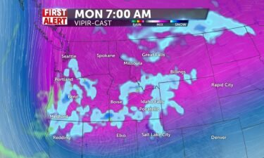
We’ll have leftover snow from a quick system that came through overnight. Slightly cooler for Thanksgiving Day with highs in the upper 20’s to lower…
Continue Reading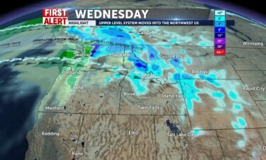
A fast-moving system will arrive late Tuesday and early Wednesday with scattered snow showers. Most locations are aiming for less than an inch in…
Continue Reading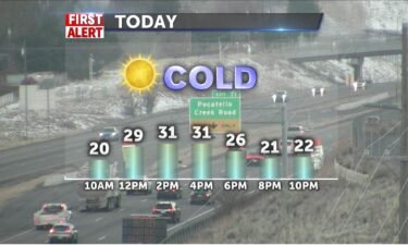
Freezing Fog Advisory in effect until 11am for Bear Lake County. Slick conditions and visibility difficulty remain an issue for areas affected by…
Continue Reading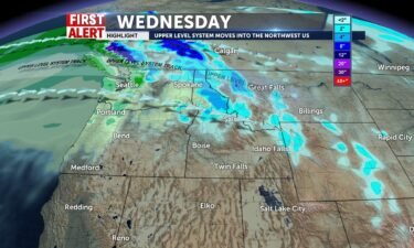
We’ll continue with dry weather for Monday evening and Tuesday. There will be a chance at some areas of fog developing overnight. Otherwise, expect…
Continue Reading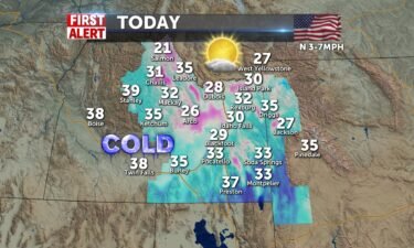
Countdown to Thanksgiving with a little warmer temperatures, if you want to call it that. We are still below averages of 40 degrees or so, with highs…
Continue Reading
Partly to mostly cloudy skies are expected on Monday to start the week, but none of the cloud cover should produce any…
Continue Reading
Mostly sunny conditions are ahead for Sunday with a chance for fog around western…
Continue Reading
High pressure overhead will keep our weather pattern the same for this weekend. Arctic air will continue to spill over the Continental Divide, with…
Continue Reading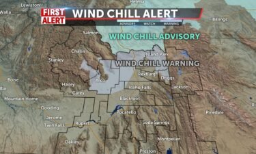
WIND CHILL WARNING IN EFFECT FROM 3 AM TO 9 AM MST FRIDAY: WHAT…Dangerously cold wind chills expected. Wind chills as low as 25 below…
Continue Reading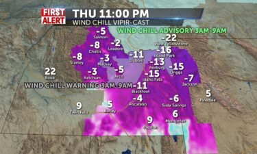
WIND CHILL WARNING IN EFFECT FROM 3 AM TO 9 AM MST FRIDAY… WIND CHILLS AS LOW AS 25 BELOW ZERO FOR MUD LAKE, INL, CRATERS OF THE MOON NM, ISLAND…
Continue Reading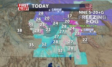
Snow showers with the front that brings colder air and windy conditions later. Wind Chill Watch for upper valley and edge of central mountains…
Continue Reading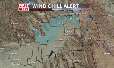
A slight chance of snow overnight with areas of freezing fog. Low temperatures around 19° overnight. Mostly cloudy, with a light wind becoming north…
Continue Reading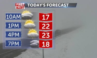
27-31 degrees and way below seasonal averages around low 40’s. A system drops in on us tomorrow and brings 30% chance of mountain and eastern…
Continue Reading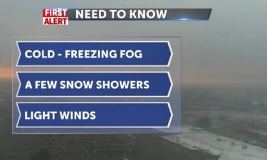
We’re still under the influence of high pressure with an inversion in place. We’ll see areas of freezing fog, freezing temperatures and a few…
Continue Reading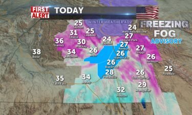
FREEZING FOG ADVISORY FROM AMERICAN FALLS to ARCO AND NORTH AND EAST TO SUGAR CITY EMCOMPASSING I-15 BUSIEST TRAVEL LANES THROUGH NOON. Highs today…
Continue Reading