June 2023 Water Supply Outlook Report released
BOISE, Idaho (KIFI) - The Natural Resources Conservation Service in Idaho has released the June Water Supply Outlook Report for the 2023 water year (WY23).
The above normal snowpack has yielded a good water supply year with above normal reservoir storage across Idaho. Warmer than normal temperatures during May drove rapid snowmelt last month. Many SNOTEL sites set records for the most amount of SWE loss during May. With peak snowpack greater than normal in many basins, water managers were busy during May trying to strike the balance of capturing the runoff for the irrigation season and ensuring the safety of downstream communities.
Weather and drought outlooks
The first part of June is expected to be warmer and wetter than normal. The 30-day monthly outlook also shows warm and wet conditions for the month. Drought status improved across central Idaho with some areas of Idaho still classified as abnormally dry (DO). Northern Idaho remains in moderate drought. The seasonal drought outlook predicts drought will persist in the Panhandle and will improve in the Snake River headwaters.
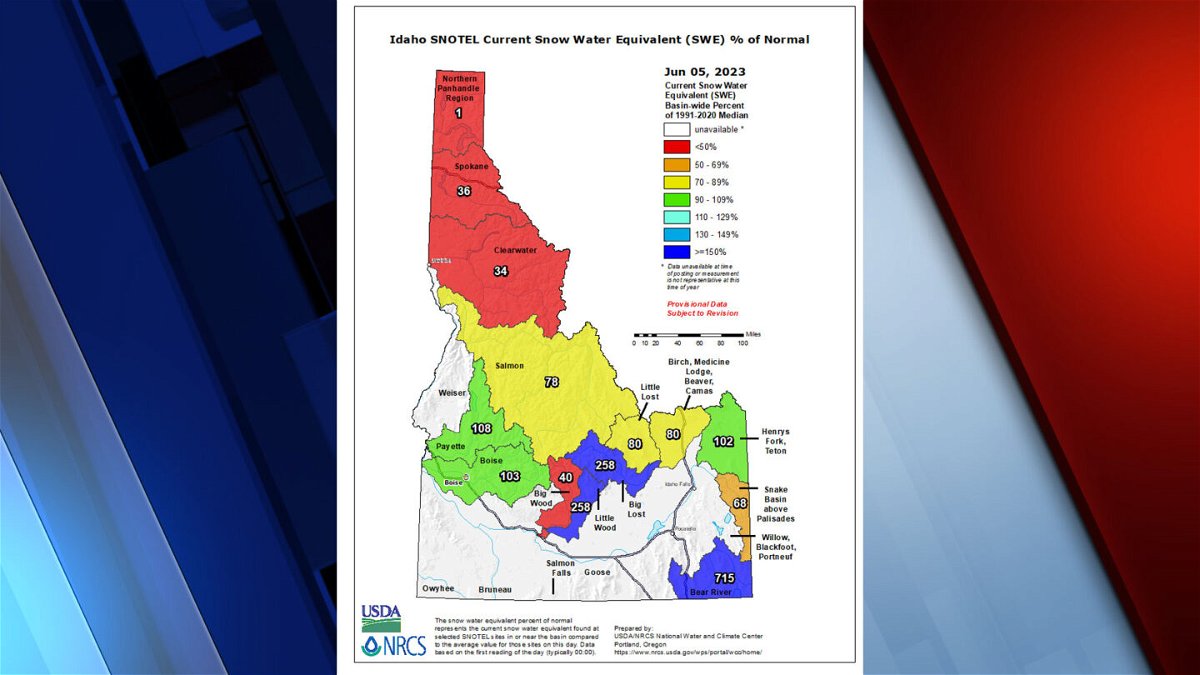
Snowpack
Warmer than normal temperatures during May drove rapid snowmelt last month. Many SNOTEL sites set records for the most amount of SWE loss during May. Despite storms that brought a little bit of new snow to high elevation sites, snowpack peaked in all basins during April. Peak snowpack was well above normal in all basins south of the Clearwater Basin. Most SNOTEL sites have melted out as of June 1. At the sites that still have snow remaining, roughly 25% of the snowpack is left on June 1. There are only seven high-elevation sites that have significant amount of snow present. Those sites have about 40% to 60% of their WY23 snowpack remaining. Freezing levels are forecasted to be above 10,000-ft during the first part of June, so it’s likely the snowpack will continue to melt rapidly and conclude by July 1.
Precipitation
May precipitation was higher than normal in the majority of the Southern Snake, Boise, Wood and Lost basins and ranged from 95% to 159% in these areas. Everywhere else in Idaho was drier than normal during May with monthly precipitation ranging from 59% to 93%. Southeast Idaho and the Upper Snake basins were the driest during May with 59% to 74% of normal precipitation.
For total water year precipitation (WYP) on June 1, northern Idaho remains the driest portion of the state, with wetter conditions in the more southern basins. WYP ranges from 79% to 81% from the Canadian border to the Clearwater Basin. WYP is 96% to 109% in the West Central and Salmon River basins. The Wood and Lost basins range from 111% to 122%. The Upper Snake basins range from 107% to 130%, with the Snake River above Heise receiving the least amount of precipitation this year at 99%. Southeast Idaho was extremely wet all winter; Bear River Basin received 131% of the normal total
water year precipitation so far. The Southern Snake basins are also very wet this year. Conditions are drier towards the west but are still well above normal. WYP ranges from 126% (Raft) to 111% (Owyhee) of normal.
Water supply and streamflow forecasts
Reservoirs continue to fill as the snowpack melts. Except in a few places like Jackson Lake and Mackay Reservoir, storage is near to above normal in reservoirs across the state. Reservoir storage in the Boise system is 91% full and the Payette system is 88% full. On June 1, reservoir storage in the Upper Snake River system (above Milner Dam) is 86% full, which is ~218 thousand acre-feet (KAF) more than average.
Observed May streamflow was well above normal across Idaho with warmer than normal temperatures driving rapid snowmelt. These ‘Snow to Flow’ graphs are very helpful to see how the timing of snowmelt corresponds to streamflow levels. The Northwest River Forecast Center (NWRFC) provide river and flood forecasts, and the USGS site shows real-time streamflow conditions.
Current streamflow, snowpack, and precipitation data for Idaho can be accessed on the NRCS Idaho Snow Survey Webpage or on the interactive map.
For information on specific basins, streams and reservoirs, view the full report below.


