FIRST ALERT WEATHER: Difficult driving New Year’s Day
Eastern Idaho was blanketed with several inches of snow New Year's morning making driving difficult on county roads and some highways.
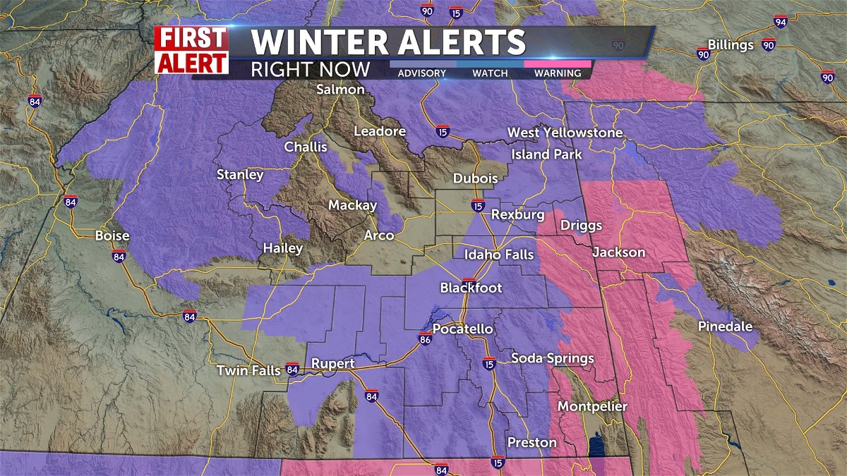
The National Weather Service issued a winter weather advisory for much of the Snake River plain ending at 5 p.m. Wednesday and a Winter Storm Warning for Jackson Hole area.
Snowfall is expected to accumulate between 4 to 7 inches in the Upper Snake River Plain from Idaho Falls to St. Anthony.
The snow is expected to taper off throughout the day, but the winds may create drifting and blowing snow along the roads.
About 1 to 3 inches of snow expected for the southern part of the state from the eastern Magic Valley, Pocatello and Preston area. The mountains could see 6 to 12 inches.
The most difficult area to travel could be the mountain passes.
To see the latest radar and current conditions, click here.
To see the latest road report, click here
To see the latest road cameras, click here
Please share video and photos of the snowstorm as you see it. Click here to send to us.
WINTER ADVISORIES ISSUED BY THE NATIONAL WEATHER SERVICE:
The National Weather Service in Pocatello, has issued a Winter Weather Advisory for the Snake River Plain.
Upper Snake River Plain-
Including Idaho Falls, Rexburg, and St. Anthony
331 AM MST Wed Jan 1 2020
…WINTER WEATHER ADVISORY IN EFFECT UNTIL 5 PM MST THIS
AFTERNOON…
.TODAY…Snow. Not as cold. Snow accumulation of 2 to 4 inches.
Highs 29 to 36. Southwest winds 10 to 15 mph.
.TONIGHT…Mostly cloudy. A chance of snow in the evening…then a slight chance of snow after midnight. Little or no snow accumulation. Lows 13 to 23. Southwest winds 10 to 15 mph. Chance of precipitation 50 percent.
.THURSDAY…Mostly cloudy with a slight chance of snow. Highs 24 to 31. Southwest winds up to 10 mph…increasing to 10 to 15 mph in the afternoon. Chance of precipitation 20 percent.
.THURSDAY NIGHT…Mostly cloudy. Lows 12 to 22. South winds up to 10 mph.
.FRIDAY…Cloudy. Highs 25 to 32. South winds around 10 mph.
.FRIDAY NIGHT…Mostly cloudy. Lows 12 to 22.
.SATURDAY…Partly sunny with a slight chance of snow. Highs 29 to 36.
.SATURDAY NIGHT…Partly cloudy. Lows 8 to 18.
.SUNDAY AND SUNDAY NIGHT…Mostly cloudy with a slight chance of snow. Highs 21 to 28. Lows 6 to 16.
.MONDAY THROUGH TUESDAY…Mostly cloudy. Highs 17 to 26. Lows 3 to 13.
$$
IDZ052-012300-
Arco/Mud Lake Desert-
Including Mud Lake, INL, and Craters of the Moon NM
331 AM MST Wed Jan 1 2020
.TODAY…Snow likely in the morning…then a chance of snow in the afternoon. Patchy blowing snow in the afternoon. Not as cold.
Snow accumulation up to 2 inches. Highs 29 to 36. Southwest winds 10 to 20 mph.
.TONIGHT…Partly cloudy. Lows 8 to 18. West winds 10 to 15 mph.
.THURSDAY…Mostly sunny. Highs 23 to 30. Southwest winds 10 to 15 mph.
.THURSDAY NIGHT…Mostly cloudy. Lows 6 to 16. West winds up to 10 mph.
.FRIDAY…Mostly cloudy. Highs 22 to 29. South winds around 10 mph.
.FRIDAY NIGHT AND SATURDAY…Mostly cloudy. Lows 7 to 16. Highs 27 to 34.
.SATURDAY NIGHT…Partly cloudy. Lows 2 to 11.
.SUNDAY THROUGH MONDAY…Mostly cloudy. Highs 17 to 24. Lows zero
to 9 above zero.
.MONDAY NIGHT…Partly cloudy. Lows 3 below to 7 above zero.
.TUESDAY…Partly sunny. Highs 15 to 22.
Lower Snake River Plain-
Including Pocatello, Blackfoot, American Falls,
Shelley, and Fort Hall
331 AM MST Wed Jan 1 2020
…WINTER WEATHER ADVISORY IN EFFECT UNTIL 5 PM MST THIS
AFTERNOON…
.TODAY…Snow in the morning…then snow and rain likely in the afternoon. Patchy blowing snow in the afternoon. Windy. Not as cold. Snow accumulation of 1 to 3 inches. Highs 35 to 42.
Southwest winds 10 to 20 mph…increasing to 20 to 30 mph in the afternoon.
.TONIGHT…Mostly cloudy. A slight chance of snow in the evening.
Breezy. Lows 19 to 29. Southwest winds 15 to 25 mph…decreasing to 10 to 15 mph after midnight. Chance of precipitation 20 percent.
.THURSDAY…Mostly cloudy. A slight chance of snow in the morning. Highs 28 to 35. Southwest winds 10 to 15 mph. Chance of precipitation 20 percent.
.THURSDAY NIGHT…Mostly cloudy. Lows 17 to 27. Southwest winds
10 to 15 mph.
.FRIDAY…Mostly cloudy. Highs 28 to 36. South winds around 10 mph.
.FRIDAY NIGHT…Mostly cloudy. Lows 16 to 26.
.SATURDAY…Mostly sunny with a slight chance of snow. Highs 33 to 40.
.SATURDAY NIGHT…Partly cloudy. Lows 11 to 21.
.SUNDAY THROUGH MONDAY…Mostly cloudy. Highs 23 to 30. Lows 10 to 20.
.MONDAY NIGHT AND TUESDAY…Partly cloudy. Lows 7 to 17. Highs 20 to 27.
Winter Storm Warning issued December 31 at 3:21AM MST until January 2 at 5:00AM MST by NWS Riverton WY
…Winter storm will impact western Wyoming New Year’s Day…
.A strong weather system will move across northwest Wyoming on New Year’s Day, bringing areas of heavy snowfall to western mountain ranges and nearby valleys. The heaviest snowfall will occur during the morning hours Wednesday, but will continue into Thursday morning.
- WHAT…Heavy snow expected. Total snow accumulations of 6 to 10
inches. - WHERE…Jackson Hole and Star Valley.
- WHEN…From 11 PM this evening to 5 AM MST Thursday.
- IMPACTS…Travel could be very difficult. The hazardous conditions could impact the morning or evening commute.
If you must travel, keep an extra flashlight, food, and water in your vehicle in case of an emergency.
The latest road conditions for the state you are calling from can be obtained by calling 5 1 1.


