Tracking sunshine and above average temps for the start of the week

A Pacific storm system brings a changing weather pattern this week, with rain chances increasing Thursday and Friday before a cooler, breezier weekend across Eastern Idaho and Western Wyoming.
Eastern Idaho and Western Wyoming are heading into a week of changing weather, starting with chilly mornings, sunshine and afternoon temperatures climbing into the 60s. But don't put those jackets away just yet. An area of low pressure off the Pacific Coast is expected to influence the weather pattern as the week progresses, bringing increasing cloud cover, scattered shower chances and gustier winds heading into the weekend.
The biggest changes are expected during the second half of the week, when cooler air and additional Pacific moisture move into the region. By Friday and Saturday, temperatures will trend downward, with daytime highs settling into the 50s and the potential for periods of rain and gusty winds.
Monday: Chilly Start, Sunny Afternoon
The week begins with a sharp contrast between early-morning and afternoon temperatures. Readings just above freezing in some locations will make for a cold start, particularly across the Snake River Plain, rural valleys and higher-elevation communities.
Sunshine will help temperatures rebound through the morning, with afternoon highs reaching the 60s across much of the lower elevations. It should be a pleasant day for outdoor chores, walking the dog, working in the yard or taking advantage of the remaining mild autumn weather.
A few clouds could develop, and there is a slight chance of an isolated shower into tonight. Most communities should have a largely dry day, however, with the best opportunity to enjoy the sunshine coming during the afternoon.
What to wear: Start with a warm jacket or hoodie for the morning commute. Lighter layers should be comfortable by afternoon, but keep a jacket handy for after sunset as temperatures fall quickly.
Tuesday: Mild With a Few More Clouds
Tuesday should remain relatively mild, although the approaching Pacific weather system may begin to make its presence felt through increasing cloud cover.
Temperatures should remain comfortable for this time of year, with many lower-elevation communities continuing to see readings in the 60s. A passing shower cannot be ruled out, but rain is not expected to be widespread throughout the day.
The overall pattern will begin transitioning away from the sunnier conditions early in the week. As moisture increases and the Pacific system approaches, the forecast will become more unsettled, particularly from midweek onward.
What to wear: Layers remain the best choice. A light jacket will be useful in the morning and evening, while a rain jacket becomes a smart addition if you'll be outdoors for extended periods.
Wednesday: Clouds Increase Ahead of the Next System
Wednesday looks like a transition day as the area of low pressure and its associated moisture move closer to the region. Cloud cover should increase, and the opportunity for showers will gradually become more noticeable.
Some locations may still enjoy dry stretches, but skies should look less consistently sunny than they do at the beginning of the week. The timing and coverage of showers will depend on how the system tracks inland and how much moisture reaches Eastern Idaho and Western Wyoming.
Temperatures may remain relatively mild in advance of the cooler air, but increasing clouds and developing showers will signal the shift toward a more unsettled pattern.
What to wear: Keep the hoodie or jacket nearby, and consider carrying an umbrella or waterproof outer layer if you're planning outdoor activities. If you have evening plans, check the latest forecast before heading out.
Thursday: Better Chances for Showers
Thursday is shaping up to be one of the more active weather days of the week. As the Pacific system moves closer and moisture spreads inland, shower chances should increase across Eastern Idaho and Western Wyoming.
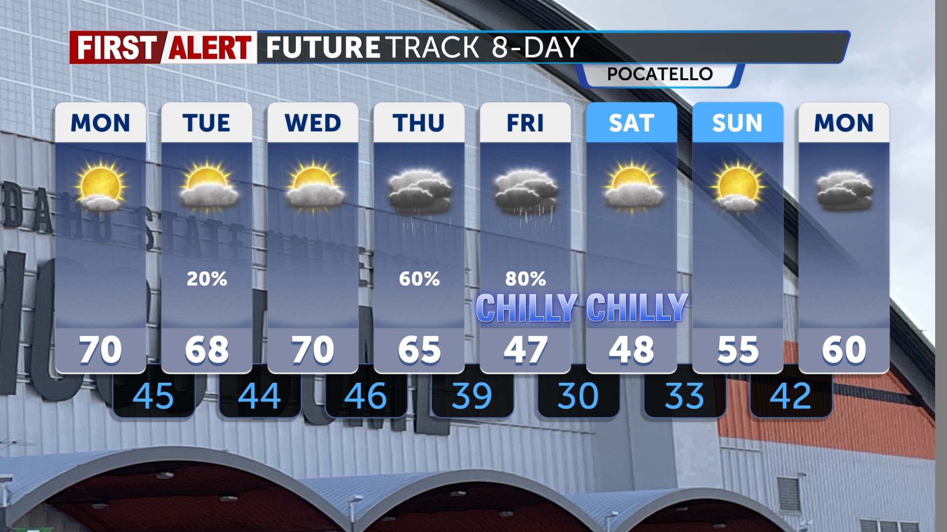
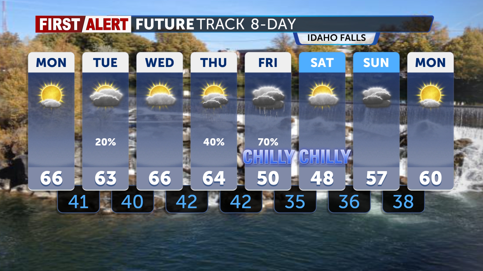
Forecast chances could reach around 40% in parts of the region, meaning scattered showers will be possible but rain will not necessarily fall everywhere. Some communities may experience a passing shower while others remain dry for much of the day.
Temperatures should trend closer to seasonal levels, with highs generally in the mid-60s where conditions allow. Increasing clouds and periods of rain could make it feel cooler, particularly in exposed areas and during the morning and evening hours.
Mountain communities and higher elevations may experience more noticeable changes as cooler air arrives. Anyone traveling through mountain passes should be prepared for changing conditions, reduced visibility during showers and cooler temperatures.
What to wear: A medium-weight jacket and rain-resistant outer layer are good choices. If you're spending time outdoors, dress for changing conditions rather than relying on the afternoon temperature alone.
Friday: Cooler, Breezier and More Unsettled
Friday will bring more of an autumn feel as temperatures fall into the 50s for afternoon highs. The Pacific system is expected to keep clouds and shower chances in the forecast, although rainfall amounts and coverage may vary from place to place.
The combination of clouds, showers and cooler air will make it feel noticeably different from the sunny beginning of the week. Winds may also become more of a factor, particularly in open areas along the Snake River Plain, exposed roadways and higher terrain.
For commuters, outdoor workers and anyone planning to travel into Western Wyoming, it's a good day to allow extra time if showers reduce visibility or winds make driving more difficult.
What to wear: Bring the warmer jacket. A waterproof shell, long pants and layers will be more comfortable than lighter clothing, especially if you'll be outside for several hours.
Saturday: Showers and Gusty Winds
Saturday currently looks like the most unsettled part of the weekend, with a better chance of showers and gusty winds as the weather system continues to influence the region.
Highs are expected to remain in the 50s, and wind gusts could approach 30 mph in some locations. Those stronger gusts may make outdoor activities less comfortable, blow around lightweight objects and create challenging conditions for high-profile vehicles on exposed roads.
Showers may come and go rather than fall continuously, so there could still be dry windows for errands or outdoor plans. However, it's wise to have a backup plan if you're organizing a tailgate, fall gathering, outdoor sports activity or a trip into the mountains.
The combination of cooler temperatures, wet pavement and gusty winds could make it feel colder than the thermometer suggests.
What to wear: A warm, wind-resistant jacket is recommended. Bring rain protection, secure loose outdoor items and check road and weather conditions before traveling through exposed areas.
Sunday: A Cooler Weekend Pattern
Sunday's exact details will depend on the track and departure of the Pacific system. The broader pattern points toward a cooler weekend compared with the start of the week, with temperatures generally closer to the 50s and lingering wind or shower chances possible if moisture remains nearby.
The best advice is to keep plans flexible and watch for updated forecasts as the weekend approaches. Conditions can vary considerably between the Snake River Plain, the Eastern Highlands and the mountains of Western Wyoming.
The Bottom Line
The week starts with cold mornings and sunny afternoons, but a Pacific low-pressure system will gradually bring more clouds and a growing chance of showers.
- Monday and Tuesday: Chilly mornings, afternoon sunshine and highs in the 60s, with only a slight shower chance.
- Wednesday: Increasing clouds as moisture moves closer.
- Thursday: Better shower chances, potentially around 40% in parts of the region, with highs near the seasonal mid-60s.
- Friday: Cooler, with highs in the 50s and additional chances for showers and breezy conditions.
- Saturday: A more unsettled day, with showers and wind gusts potentially reaching 30 mph.
- Sunday: Cooler conditions continue, with lingering unsettled weather possible.
For now, enjoy the early-week sunshine, but keep those jackets handy. By Thursday and Friday, the weather pattern should look and feel more like fall, with showers, cooler afternoons and a breezier finish to the week.