Moose Fire remains 51% contained

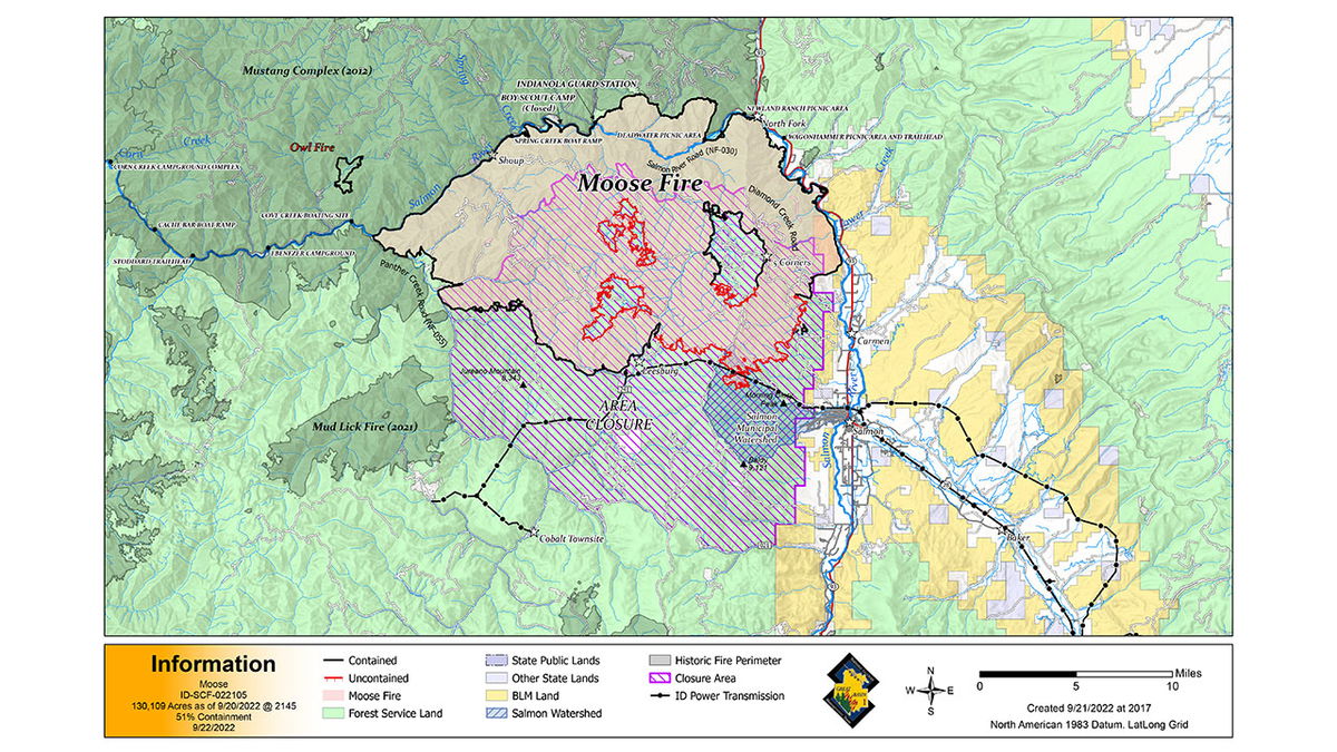
SALMON, Idaho (KIFI) - The human caused Moose Fire burning west and south of North Fork has burned 130,109 acres and is 51% contained.
Precipitation over the fire area Wednesday night was between 1/4 and 1/3 inches with scattered showers expected for today along with gusty winds and colder temperatures. The moisture and higher relative humidity have slowed the fire movement. Continued smoldering and creeping fire behavior should be expected. Rain and gusty winds have weakened snags with potential debris on the roadways, and heavy equipment is being positioned to aid in debris removal.
The Owl Fire, which is 100% contained, was transferred back to the Salmon- Challis National Forest yesterday evening. A rain gauge near the fire received almost 1/2 inch of rain last night.
Expect delays on Williams Creek Road Thursday as large single wide trailers are transported to Cobalt Mine. Pilot cars will be in place to escort traffic on the road beginning at 9 a.m.
Drones with infrared (IR) sensors will be used in the Bob Moore, Fenster and Sharkey Creek areas to locate heat source and help direct firefighters when safe to engage. Suppression repair operations are continuing throughout the fire area. Suppression repair objectives are to return damaged areas to a stable condition that reflects pre-fire conditions.
EVACUATIONS
Zones 11, 12, and 13 have been moved back to “READY” status. Zones 1 will remain in “SET” status for now. Beartrack Mine, and Leesburg remain in "READY" status. Zones 3, 4, 7, 8 and 10 have been rescinded and are no longer in evacuation status. The Incident Management Team will continue to work closely with the Sheriff’s Office to consider changes to the evacuation status.
Additional details are at: https://bit.ly/LemhiCountyEvacs
CLOSURES AND RESTRICTIONS
A Salmon-Challis National Forest closure order was updated on September 19. It reduces the closure area lands north of Williams Creek and Deep Creek Roads, east of Panther Creek Road, and south of North Fork Ranger District/Salmon-Cobalt Ranger District. The closure includes national forest service lands pertaining to certain roads, trails, and a defined geographic area around the fire. See Moose Fire Emergency Area, Road, and Trail Closure, Order #04-13-22-512 for complete description. This closure applies to hunting access, firewood cutting and gathering, fishing, hiking, camping, and other recreational activities.
- Public Lands north of the town of Salmon, south of Wallace Creek, and west of the Salmon River administered by the Salmon Field Office, Bureau of Land Management (BLM) are temporarily Closed.
- Stage 1 Fire restrictions are in effect on the Salmon-Challis National Forest, BLM, and State of Idaho lands in Custer and Lemhi Counties, excluding wilderness areas.
- For more information about area hunting units, please visit the Idaho Fish and Game fire map: https://fishandgame.idaho.gov/ifwis/maps/realtime/fire/ or the Idaho Fish and Game Salmon Region Facebook page https://www.facebook.com/IDFG.salmon.


