FIRE WATCH: Latest information on area wildfires
LATEST INFORMATION
The information below comes from fire managers daily updates.
RED ROCK FIRE
(UPDATED 10/15/2024)
Fire Size: 76,288 acres
Containment: 19%
Personnel: 571
Monday crews focused on searching for remaining heat to extinguish south of the cobalt mine. Crews also completed handline on the off Blackbird Road (FR 115) around the mine. More cutting of vegetation further east on Blackbird Road continued, but there are no immediate plans to conduct ignitions off that road unless necessary. Crews and unmanned aircraft used ignitions along the Ridge Road (FR 020) to Williams Creek Summit to remove fuel ahead of the southwest wind shift. Dozer line construction continued off Moyer Peak and engines patrolled and mopped up around structures in Forney, Cobalt and Moyer.
Tuesday firefighters are preparing for forecast change in weather later this week, making sure pumps and equipment won’t freeze. With the incoming cold front, crews are focused on the northeast corner of the fire near Williams Creek Summit where winds could test the control lines.
On the spot fire near Napias Creek, crews built additional line closer to the fire’s edge and mopped up hot spots. Today they will continue mopping up any remaining heat.
GARDEN FIRE
(Reported 10/15/2024)
Size: 10,532 acres
Containment: 0%
Personnel: 63
No significant fire growth was observed Monday. Aerial reconnaissance showed many unburned areas within the perimeter. Crews will remain vigilant in their patrol and mop up.
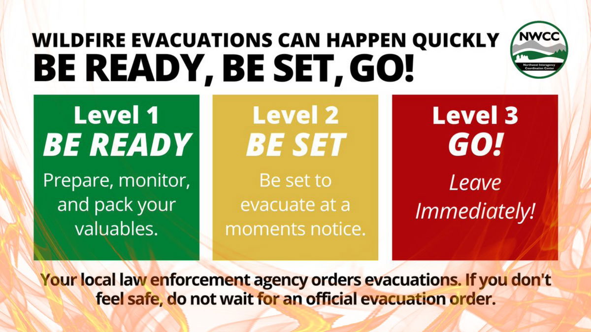
Evacuations: Lemhi County Law Enforcement, Emergency Management, and the Salmon-Challis National Forest have established three (3) evacuation zones for the Garden Fire.
Zone 1: From Cove Creek to Ebeneezer Bar, downriver along the Salmon River Road #030.
Zone 2: On Panther Creek Rd #055, a half mile south of Beaver Creek Rd #057 to the Salmon River Rd #030 confluence.
Zone 3: Panther Creek to Spring Creek to include private land up Spring Creek
- ZONE 1 is in “GO” status
- ZONE 2 is in “GO” status
- ZONE 3 IS IN "SET" STATUS
Information on evacuation status can be found on Lemhi County’s website, https://www.lemhicountyidaho.org/, under ‘News and Notices.’
PACK TRAIL FIRE
(Reported 10/15/2024)
Size: 86,555 acres
Containment: 62%
Personnel: 613
California Team 10 will transition command of the fire to Great Basin Team 5 at 0700 tomorrow, October 16th.
Operations – Tuesday, shifting winds, picking up in the afternoon, will likely lead to increased fire activity. Monday, on the east side of the fire, ground crews secured hot spots along the 540 Road, continued cleaning up containment lines along Trout Creek. On the South side, the Pack Trail Fire continued to slowly move into areas around Cowboy Camp, Strawberry Warming Hut, and Fish Creek Guard Station. Firefighters utilized aircraft to suppress hot spots, while mopping up, patrolling, maintaining and testing sprinkler systems set up around homes and other values at risk. The fire remains confined north of Union Pass Road. On the west flank, in the Gros Ventre River Basin, firefighters are patrolling the Burnt Ridge area and also using aircraft to slow the fire’s incursion into the valley. There has been a major effort to prepare and protect a stand of endangered White Bark Pine. The structure protection group continues wrapping buildings in protective foil, laying hose lines, and setting up sprinkler systems around additional structures. Night crews continue to patrol accessible areas of the fire and reported there was minimal fire activity in the interior and nothing that threatened the containment lines overnight.
Evacuations – Brooks Lake Lodge, Pinnacle Cabins, Falls Camp, and Long Creek have been reduced to a Level 2 “Set” Evacuation Warning. Level 3 “Go” evacuation orders remain in effect for Lava Mountain Lodge and McKenzie Highland Ranch. The Dunoir Road Corridor has been reduced to a Level 1 “Ready” Evacuation Warning. See theFremont County Emergency Management Facebook Page for alerts and updates. See the Teton County Emergency Management website updates and to sign up for emergency alerts through Everbridge.
Road Closures – The Union Pass Road is closed on the Pinedale District (BTNF) from Mosquito Lake to the DuNoir on the Wind River District (SHO).
Forest Closures - Closure Order #04-03-24-316 is in effect from October 9, 2024 at 12:00 p.m. through November 1, 2024 at 6:00 a.m. unless rescinded. This order supersedes previous orders, including #04-03-24-315, prohibiting the same or similar acts in the same described area.

(Reported 10/15/2024)
Size: 1,425 acres
Containment: 9%
Personnel: 44
Located: Approximately 10 miles southwest of Lyons Bridge on HWY 287 in the Meridian Creek Drainage of the Beaverhead-Deerlodge National Forest.
The Meridian Fire was reported late in the day on October 8th and is located approximately 10 miles southwest of Lyons Bridge on HWY 287 in the Meridian Creek Drainage. Fire managers from the Beaverhead-Deerlodge National Forest have identified and prioritized critical values at risk in the fire area. Firefighting efforts will focus available resources on the protection of structures approximately ½ mile from the fire.
The fire doubled in size Monday, October 14, after it spotted across FS Trail 6019 and moved to the east/northeast to the top of Cliff Lake Bench. Resources remained in a safety zone until fire behavior allowed for re-engagement to scout where the fire had moved to and potential containment features. One Type 1 helicopter was used to drop water were effective and provided aerial views and information of the fires spread. The rest of the fire showed minimal fire activity throughout the day. Contact was made with Cliff and Wade Lake Resort in the evening and an assessment of people in the campground was completed. Madison County Sheriff’s office was updated on the fire situation. A higher-level Incident Commander, one Air Attack, two Type 1 helicopters, and two engines were ordered.
To see the latest on other fires, visit inciweb.wildfires.gov


