FIRE WATCH: Latest information on area wildfires
LATEST INFORMATION
The information below comes from fire managers daily updates.
RED ROCK FIRE
(UPDATED 10/17/2024)
Fire Size: 77,879 acres
Containment: 19%
Personnel: 596

Yesterday, fire operations focused on addressing any areas of concern ahead of the cold front. Ignitions continued around the Williams Creek Summit to close off the northeast corner of the fire. Machinery and crews continued to remove fuels along the Ridge Road south to Lake Mountain. The fire in Salt Creek was very active, but burned towards the old Salt Creek burn scar where it is expected to moderate. Crews built direct line in Forth of July Creek and Moyer Creek. Helicopters were used to cool down hot spots on the interior of the fire. Mop up continued on the spot fire in Napias Creek.
Today, crews will see what the change in weather provided. Aircraft will assess all areas of the fire to determine what additional actions are needed. Crews will continue vegetation removal south along the Ridge Road and any necessary direct line construction in Forth of July Creek and Moyer Creek. Any remaining heat from yesterday’s ignitions near Williams Creek Summit will be mopped up. The need for additional ignitions will be assessed.
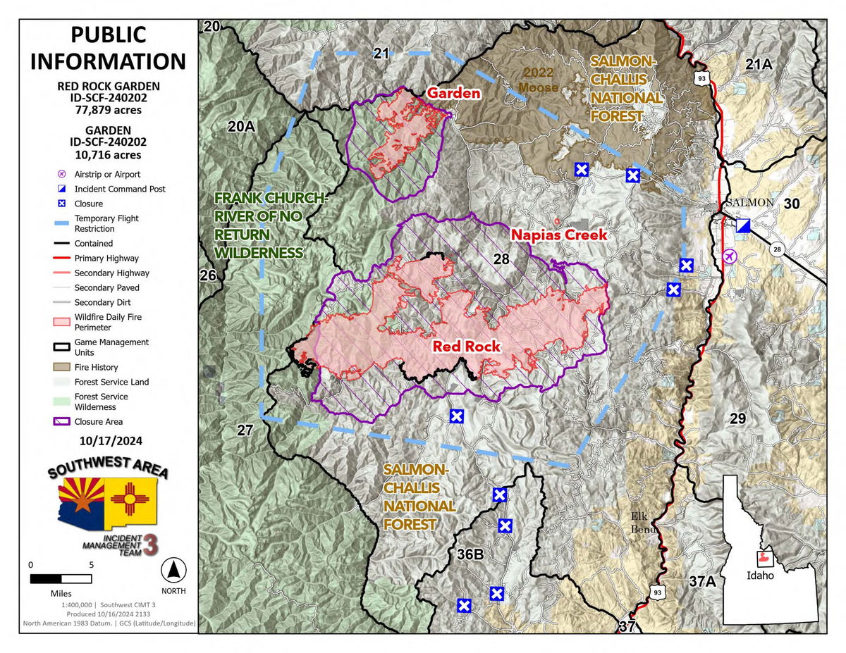
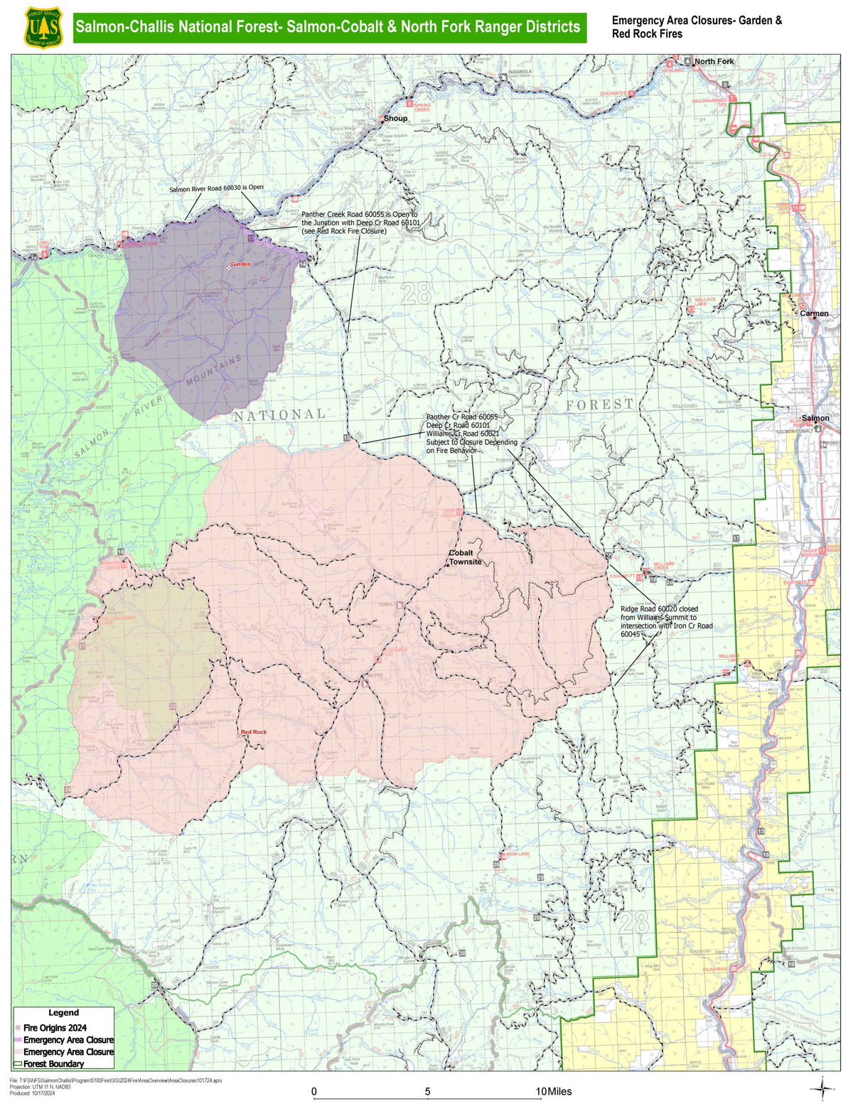
GARDEN FIRE
(Reported 10/17/2024)
Size: 10,716 acres
Containment: 1%
Personnel: 76
Yesterday resources continued to patrol and mop up the fire’s edge. Due to the fire’s location, how it initially burned and difficulty accessing, mop up may take time. However, today the crews will assess the effects of the weather helping to meet the objective to keep the Salmon River and Panther Creek secure.
Evacuations: Lemhi County Law Enforcement, Emergency Management, and the Salmon-Challis National Forest have established three (3) evacuation zones for the Garden Fire.
Zone 1: From Cove Creek to Ebeneezer Bar, downriver along the Salmon River Road #030.
Zone 2: On Panther Creek Rd #055, a half mile south of Beaver Creek Rd #057 to the Salmon River Rd #030 confluence.
Zone 3: Panther Creek to Spring Creek to include private land up Spring Creek
- ZONE 1 is in “GO” status
- ZONE 2 is in “GO” status
- ZONE 3 IS IN "SET" STATUS
Information on evacuation status can be found on Lemhi County’s website, https://www.lemhicountyidaho.org/, under ‘News and Notices.’
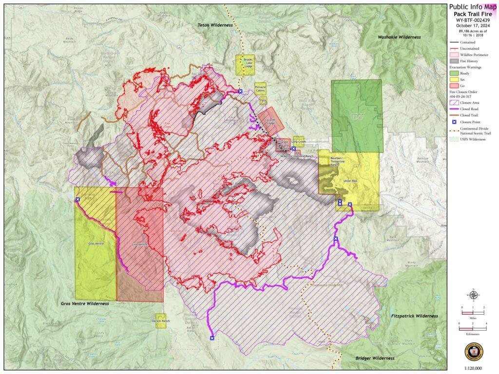
PACK TRAIL FIRE
(Reported 10/17/2024)
Size: 89,186 acres
Containment: 62%
Personnel: 618
Operations – Wednesday, on the north side, firefighters continued cleanup from a previous tactical firing operation. Helicopters continue to cool hotspots south of the 645 road. On the east side, crews continued to improve defensible space near structures in the Union Pass Subdivision. Near the 540 Road, the fire is holding within containment lines, but the abundant dead and down within the interior continues to burn with isolated torching. On the south side, fire was active and moved through mixed conifer stands along Union Pass Road near Buffalo Meadow. On the west flank, the fire continues to be active at upper elevations within the dry and dead timber. The wet, grassy meadows at lower elevation are providing a natural barrier where the fire moves slower. Due to the incoming winter weather, and safety hazards associated with driving at on icy roads, staffing a nightshift will be suspended going forward.
Evacuations – Brooks Lake Lodge, Pinnacle Cabins, Falls Camp, and Long Creek have been reduced to a Level 2 “Set” Evacuation Warning. Level 3 “Go” evacuation orders remain in effect for Lava Mountain Lodge and McKenzie Highland Ranch. The Dunoir Road Corridor has been reduced to a Level 1 “Ready” Evacuation Warning. See theFremont County Emergency Management Facebook Page for alerts and updates. See the Teton County Emergency Management website updates and to sign up for emergency alerts through Everbridge.
Road Closures – The Union Pass Road is closed on the Pinedale District (BTNF) from Mosquito Lake to the DuNoir on the Wind River District (SHO).
Forest Closures - Closure Order #04-03-24-316 is in effect from October 9, 2024 at 12:00 p.m. through November 1, 2024 at 6:00 a.m. unless rescinded. This order supersedes previous orders, including #04-03-24-315, prohibiting the same or similar acts in the same described area.

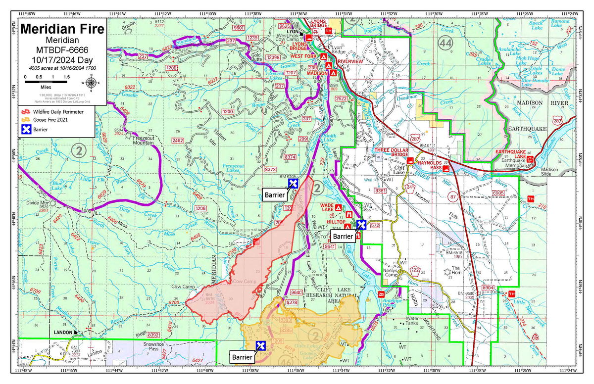
(Reported 10/16/2024 6 p.m.)
Size: 4,005 acres
Containment:
Personnel: 74
Located: Approximately 10 miles southwest of Lyons Bridge on HWY 287 in the Meridian Creek Drainage of the Beaverhead-Deerlodge National Forest.
The fire was active today, burning in timber between FS 209 road (West Fork of the Madison Road) and FS 1209 road (the Cliff Lake Bench Road). Fire progression was to the north-northeast, given the southerly winds. The fire spotted across FS 1209 road. The northern and eastern flanks of the fire exhibited active fire behavior, with group torching and short-range spotting. The southeast flank burned into the Goose Fire footprint from 2021. The western and southern flanks did not exhibit significant growth today.
Ground resources utilized two large helicopters and two VLATs (Very Large Air Tankers) to aid in slowing the fire’s progression to the north. Firefighting personnel continued to secure and protect the West Fork Cabins.
Fire managers coordinated with the Madison County Sheriff’s Office, who issued an evacuation warning to homeowners on Sundance Bench and in Madison River Ranches at 2:00 p.m. this afternoon. Fire managers also coordinated with range permittees to move cattle from the affected fire area.
Tomorrow’s plan is to reassess the fire perimeter location, weather conditions, and critical values at risk, focusing the main suppression efforts on the northeast flank nearest the private land and structures. Private landowners affected by the fire are encouraged to pay close attention to forecasted weather conditions, as they may affect changes in evacuation status.
“Do Not Report” signs remain in place at Raynolds Pass and the junction of HWY 87 and HWY 287 by Three Dollar Bridge to minimize 911 calls impacting Madison County Dispatch. Information boards are still in place at the MT DOT Rest Area at Lyons Bridge and Cliff/Wade Lake Campground. The smoke from this fire along with other fires west of here will pool in low areas along the Madison and West Fork Madison tonight.
Barriers are in place at the junction of FS RD 209 and 1209 (West Fork and Jack Pine) to limit vehicle traffic to Miller Flat and onto Cliff Lake Bench. Another barrier is in place at Cliff and Wade Lake Campground to limit traffic into the campground. Additional barriers are in place at Hoodoo Pass and Miller Flat to reduce ATV/UTV traffic in the fire area. Fire resources will be focused on protecting critical values at risk, scouting the fire, locating and assessing values, finding viable features to reduce fire spread, and working available aircraft in areas where they can be successful.
These actions are designed to allow fire personnel to protect the identified values at risk while operating in areas that have much better access and egress to safety.
To see the latest on other fires, visit inciweb.wildfires.gov


