FIRE WATCH: Updated closures for Red Rock/Black Eagle and Garden Fire
LATEST INFORMATION
The information below comes from fire managers daily updates.
RED ROCK FIRE - BLACK EAGLE FIRE
(Reporter 10/8/2024)
Fire Size: 57,893 acres
Containment: 15%
Active fire behavior continues in the fire area, including group torching and short crown runs in drainages that were in alignment with west-southwest winds. Crews have been reinserted and are engaged in direct perimeter control, focused on point protection. The fire is in a full suppression and point protection strategy, utilizing a mix of tactics including direct and indirect attack. Firefighters are engaging the fire directly when the probability of success is high and commensurate with the values at risk.
Lemhi County Sheriff’s Office is enforcing several evacuation notices for the areas of Panther Creek, Forney, Moyer, Cobalt, Blackbird, and Leesburg. Crews are coordinating with the county to assess damage in the fire area. If any structures are identified that have been damaged or destroyed, Lemhi county officials from either the Sheriff’s Office or the Emergency Management Services Office will notify property owners.
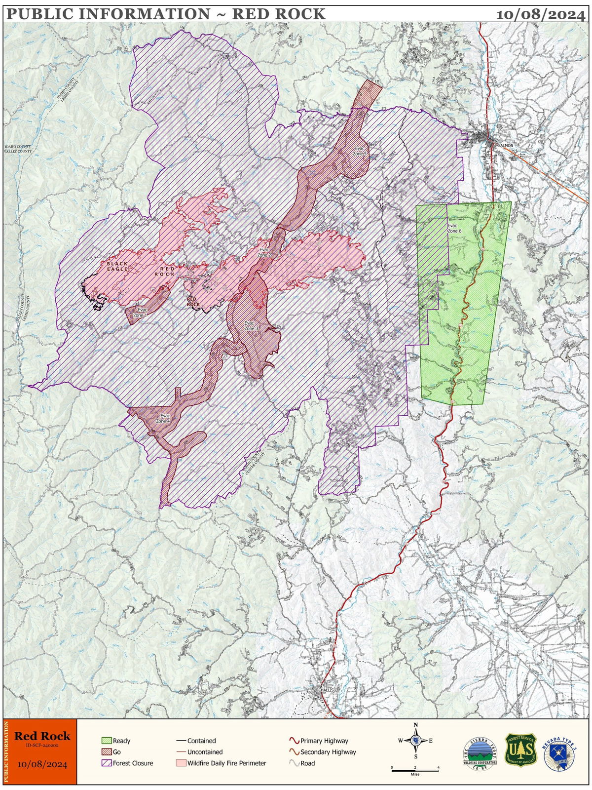
Please stay out of the fire area. There is still active fire behavior in the fire area, including group torching and crown runs. There are multiple roads and bridges that have been destroyed or are impassable. Entry into evacuation zones that are in “Go” status is prohibited. The updated forest closure notice that encompasses both the Red Rock Fire and Garden Fire areas includes multiple road and area closures. Barricade closures will be posted at road intersections and forest boundaries.

Closures (Oct. 7th)
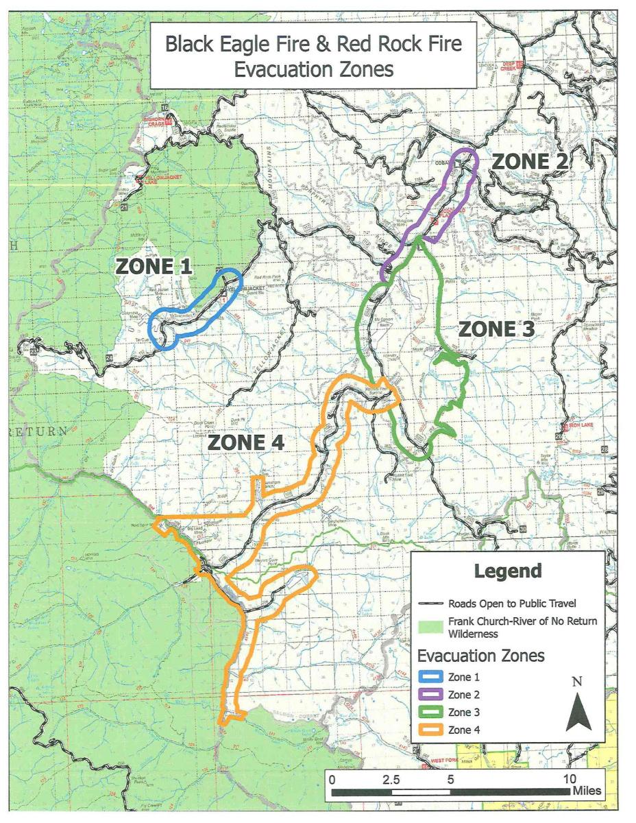
EVACUATIONS ISSUED BY THE LEMHI COUNTY SHERIFF'S OFFICE:
ZONE 1 - REMAINS IN “GO” STATUS
ZONE 2 – REMAINS IN “GO” STATUS
ZONE 3 – REMAINS IN “GO” STATUS
ZONE 4 – REMAINS IN "GO" STATUS
ZONE 5 – REMAINS IN “GO” STATUS
ZONE 6 – REMAINS IN “READY” STATUS
Zone 1: Yellowjacket drainage
Zone 2: Cobalt to Forney
Zone 3: Forney to road #252 to road #103 and back to Moyer
Zone 4: Silver Creek, Rams Creek, and Camas Creek from Hammer
Creek to White Goat Creek
Zone 5: Cobalt to Blackbird and Leesburg.
Zone 6: US-93 corridor from Williams Creek to Elk Bend.


GARDEN FIRE
(Reported 10/8/2024)
Size: 7,793 acres
Containment:
Location: approximately 2 miles southwest of the confluence of Panther Creek and the Main Salmon River on the North Fork Ranger District in the Frank Church River of No Return Wilderness.
Fire Resources: 1 Type 1 Crew, 1 Type 2 Crew, 8 Engines, 4 overhead, and 2 Type 2 crews are enroute.
Firefighter and public safety is the number one priority for the Garden Fire. Fire managers are using a combination of full suppression and a point protection strategy (a wildfire response strategy, which protects specific assets or highly valued resources from the wildfire without directly halting the continued spread of the wildfire) to minimize exposure to fire personnel while protecting identified values, including private property and Forest Service infrastructure.
Yesterday, the inversion layer did not lift and continues to limit the use of aircraft. The fire continues to grow in the Garden Creek drainage and to the ridge to the north, towards the Salmon River. Fire is currently holding in the upper reaches of Clear Creek, however between lower Clear Creek and Dry to Bear Gulch, the fire is backing down towards Panther Creek. Due to limited visibility, fire managers are using an Unmanned Aircraft System (UAS) technology for infrared flights and small scale firing operations to help secure the fire’s edges.
With additional resources arriving, the fire has added a night shift. Presence of firefighters, primarily in the Panther Creek and Salmon River areas continues today as crews continue to work to evaluate and assess various point protection strategies to minimize impacts to values in the area. Fire managers are scouting for opportunities to use the UAS for small scale firing operations to hold the fire above the Salmon River. Aircraft, both fixed wing and helicopters, will be used if weather and smoke conditions allow. Fire managers are continuing to look for opportunities to engage the fire direct as fuels and weather conditions change and it is safe to do so.
Zone 1: From Cove Creek to Ebeneezer Bar, downriver along the Salmon River Road #030.
Zone 2: On Panther Creek Rd #055, a half mile south of Beaver Creek Rd #057 to the Salmon River Rd #030 confluence.
ZONE 1 is in “GO” status
ZONE 2 is in “GO” status
PACK TRAIL FIRE and FISH CREEK FIRE
(Reported 10/7/2024)
Fish Creek Fire
Size: 25,371 acres
Containment: 95%
Personnel: 312
Pack Trail Fire
Size: 58,065 acres
Containment: 60%
Personnel: 563
Note: Personnel numbers reflect assignments based on accounting code for each fire, not location of crews. The majority of resources are on the Pack Trail Fire.
Yesterday, on the west side of the fire, parallel to the Purdy Fire footprint, the fire continued to move south into Strawberry Basin. However, it remained east of Burnt Ridge, where westward winds pushed the fire back onto itself.
Fire crews will continue scouting for natural features to help contain the fire’s spread, identifying structures that require protection, and contacting homeowners in the “set” evacuation zone. On the north side, small pockets of interior heat were located and suppressed by helicopter water drops and an engine crew. Meanwhile, road crews are continuing repairs on Flagsta[ Road. On the east, the overnight high humidity and cooler temperatures helped calm the fire, which remains contained west of 540 Road. East of Highway 26, in the Pinnacles and Brooks Lake areas, firefighters will continue to lay hose lines, set up sprinklers, and fill portable water tanks near structures. In the south, fire crews are working to establish a connecting fuel break between 532 Road and Union Pass Road.
WAPITI FIRE
(Reported 10/7/2014)
Size: 126,817 acres
Completion: 80%
Total Personnel: 186
Sunday, increased fire activity was apparent on both the Wapiti and the Frog Fires, producing smoke in several interior areas, but not threatening containment lines. Increased smoke also showed an uptick in fire activity in the Sawtooth Wilderness, the southeast corner of the Wapiti Fire, where the fire is burning through isolated timber stringers in very rugged and inaccessible terrain.
While firefighters have completed most suppression and repair activities, Monday crews will be working in several areas on both the Wapiti and the Frog Fires. Engine and hand crews will patrol containment lines and use helicopters to monitor internal fire activity. A Wildland Fire module will work on the Frog Fire, maintaining containment lines in the northeast part of the fire, and searching for the heat signature found by an infrared flight in the Red Ridge area. On the Wapiti Fire, a task force will be in the Grandjean area to remove hazardous trees and debris, restore access to the Sourdough area, and monitor the area. Firefighters will continue to remove fire-weakened hazard trees, or “snags” and clearing debris in the fire area on several closed Forest Service roads including Stanely Lake road and along Hwy 21.
FROG FIRE
(Reporter 10/7/2024)
Size: 3,114 acres
Containment: 77%
Total Personnel: 30
Firefighters will not preemptively engage directly with the Frog Fire today due to the Red Flag Warning and strong winds but will be located in a safe vantage point on the western side of the fire and will respond to increased activity if it is safe to do so. Yesterday, a helicopter worked remaining hotspots with water drops as added precautions prior to today’s weather event.
COMMISSARY FIRE:
(Reported 10/5/2024)
Size: 4,943
Location: Fourteen miles south of Swan Valley, Idaho
Fire resources – 1 Helicopter, 2 engines, 3 crews, and miscellaneous overhead
Fire managers continue to be actively engaged on the Commissary Fire which is
burning within the Fall Creek Prescribed fire project area on the Palisades Ranger District.
This fire is continues to burn at a low intensity which provides benefits that include improving forest health, minimizing the spread of insects and disease, removing and reducing invasive species that threaten native species in an ecosystem, improving habitat for numerous species, recycling nutrients back into the soil and promoting the growth of aspen in the area.
While there are no current trail or area closures in place, forest visitors are encouraged to stay informed and exercise caution if recreating in the vicinity of the Commissary Fire area. Continue to be aware of rapid fire spread, rolling debris, falling snags or trees, and periods of heavy smoke. Additionally, there will be an increase in traffic along the Skyline Road. Please slow down and use caution when driving.
To see the latest on other fires, visit inciweb.wildfires.gov


