Mud Lick, Haynes and Iron Fire updates
SALMON, Idaho (KIFI) - Crews continue to fight the Mud Lick, Haynes and Iron Fires.
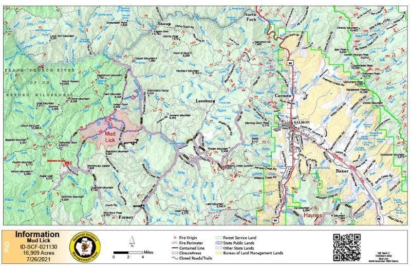
MUD LICK FIRE
The Mud Lick Fire started by lightning on July 8, 2021. The fire is located approximately 23 miles due west of Salmon, Idaho on the Salmon-Cobalt Ranger District. The fire is burning in grass, brush, dead/down timber, and trees and is burning in the 2000 Clear Creek Fire scar, north and east of the Bighorn Crags and west of Panther Creek near the Blackbird Mine.
It is 50% contained and has burned 16,909 acres.
The Mud Lick Fire continues to be managed utilizing confine-contain and point protection strategies due to the steep, rugged and inaccessible terrain surrounding the fire area. Additionally, on the western perimeter, the fire is burning into the Frank Church River of No Return Wilderness and protecting the wilderness value is a primary objective on the west side of the fire.
Fire managers have identified Panther Creek Road and Ridge Road as primary and secondary features to confine and contain the fire and resources are focusing fire line preparation and improvements, including brushing, chipping, and timber removal utilizing heavy equipment, along these routes.
Where structures and infrastructure exist near the fire, crews are implementing point protection actions such as brushing, chipping, building fire line and using pumps, hose and sprinklers to wet areas near structures and helicopters to drop water on hot spots in order to reduce fire behavior and the risk that fire may pose to these values.
As of Monday, crews have completed 50% of objectives to confine and contain the Mud Lick Fire.
Haynes Fire
The lightning-caused Haynes Fire started on July 16 and is located at the headwaters of Haynes Creek on the Leadore Ranger District.
It is 45% contained and has burned 472 acres.
Minimal fire behavior was observed Sunday with little to no perimeter growth. The fire is primarily smoldering in heavy dead/down fuels and burning snags in steep terrain. Yesterday helicopters were used to drop water on hot spots near the fire’s edge on the north perimeter. Monday, crews are securing and patrolling fire line and continue to construct containment line along the eastern perimeter of the fire.
The Salmon‐Challis National Forest has implemented Haynes Fire Emergency Road Closure, Order Number: 04‐13‐21‐008. Road closures went into effect on July 19th for portions of Baldy Basin Road (NFSR #60152), Haynes Basin Road (NFSR #60016), K Mountain Road (NFSR #60427), Twelve‐mile Creek Road (NFSR #60014).
Roads are closed to all uses including hiking, biking, motorized use, and horse travel. Visit the Forest’s website at www.fs.usda.gov/scnf/ for more information regarding the closures.
The Bureau of Land Management, Salmon Field Office, has implemented an emergency road closure affecting public lands in the Haynes Creek and McDevitt Creek areas in Lemhi County, Idaho to provide protection to visitors from the current fire safety hazards, wildfire activity and fire suppression activity.
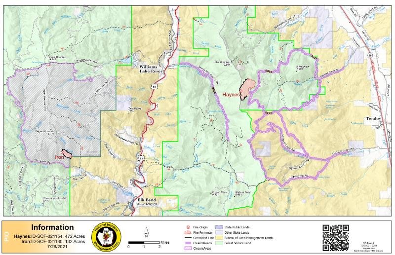
Iron Fire
The Iron Fire was started by lightning on July 17th and is located southwest of Badger Creek on the Salmon-Cobalt Ranger District.
It is 95% contained and has burned 132 acres.
The fire continues to smolder in heavy downed timber in the interior with no perimeter growth. Resources are monitoring the inaccessible portion of Badger Creek drainage and will use helicopters to drop water on flare ups near the fire perimeter as needed.
Evacuations are in place for Panther Creek (NFSR 055) from Deep Creek north to the main Salmon River Road (NFSR 030) and in Napias Creek (NFSR 0242). Road closures are in place for Panther Creek, Ridge Road (NFSR #020) north of Williams Creek, Summit Baldy Basin (NFSR #0152), Haynes Basin Rd (NFSR #60016), K-Mountain (NFSR #60427), Twelvemile Creek Rd (NFSR #60014), and McDevitt (NFSR #0150). An area closure is in place for the Iron Fire. See the Forest’s website for full descriptions of road closures and fire restrictions at www.fs.usda.gov/scnf/.


