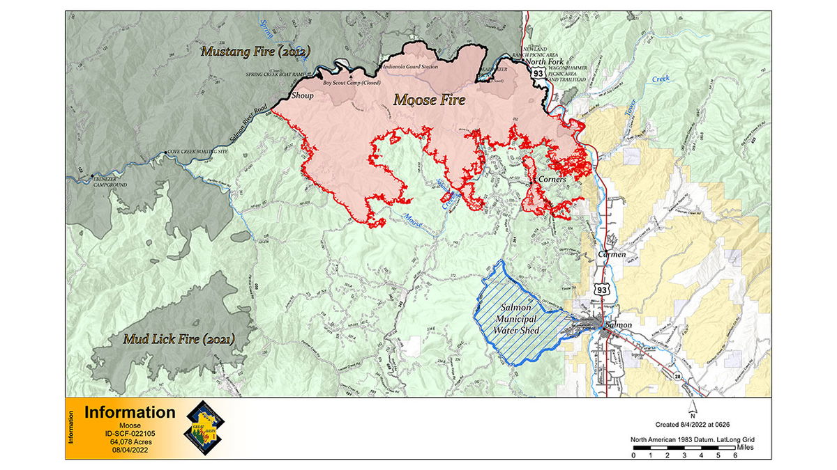
Moose Fire community meeting set Thursday

SALMON, Idaho (KIFI) - The human caused Moose Fire burning near North Fork has burned 64,078 acres and is 20% contained.
There will be an in-person community meeting Thursday at 6 p.m. held outdoors at the Sacajawea Center Amphitheater, 2700 Main Street in Salmon. The meeting will also be streamed on Facebook if connectivity permits.
The Moose Fire is burning in very steep, hazardous terrain that has been historically dangerous for firefighters. Warm, windy, dry weather and extremely dry fuel conditions continue to produce active fire behavior and fire growth. The National Weather Service issued a Red Flag Warning from 12:00 p.m. Thursday through 9:00 p.m. for the fire area due to gusty winds and low relative humidity. Winds from the southwest could gust as high as 48 mph. Expect temperatures across most of the fire area to range from 80°F to 90°F, with a slight chance of afternoon thunderstorms and scattered showers later Thursday, potentially accompanied by gusty, erratic winds, and dry lightning. Firefighters expect to face very active fire behavior. Fire is likely to spread quickly, especially in areas where the winds align with topography.
Very active fire behavior was observed Wednesday in the Jackass Ridge and Daily Creek Areas. Supported by water and retardant drops, Wednesday ground crews focused suppression efforts on a 100-acre spot fire south of the Diamond Line and Ridge Road. Air tankers also dropped fire retardant yesterday evening to assist ground crews to secure the fire that slopped over the ridge before the cold front passes through the area. Crews today are scouting, assessing, and creating containment plans in the rugged terrain on the south and western sides of the fire. Crews continue to assess and protect structures in Panther Creek, Pine Creek, Shoup, and Leesburg areas, and along Highway 93. Further south, firefighters are working to strengthen fuel breaks along the Ridge Road and Williams Creek Road.
The Pilot Car System on Salmon River Road continues to operate with two-way traffic between North Fork and Panther Creek, with a pilot car on both ends. Be prepared for potential temporary delays through the fire area. The pilot car system is for residents, river permit holders and river shuttles. The road is closed to all other traffic.
Alternative route: Williams Creek Rd (021) to Deep Creek Rd (101), then north on Panther Creek Rd (055). Stay on the most traveled roadway. This route is long and unpaved, and drivers should be prepared for heavy mining and recreation traffic, including semi-trucks and vehicles with trailers.
EVACUATIONS and SHELTER
The Lemhi County Sheriff has placed Zone 2 (both sides of Highway 93 from Tower Creek to North Fork) in “SET” evacuation status. Zones 7 & 8 (Squaw Creek to Pine Creek on the Salmon River Rd) and Zone 1
(Tower Creek to Carmen, west of Salmon River) are at "SET" status. All other zones are in “Ready” status. The latest updates from the Lemhi County Sheriff’s Office can be found HERE. The fire remains very active and all residents in proximity of the fire should follow the Ready!Set!Go! guidance. A shelter is available at the Salmon Valley Baptist Church (1230 Cemetery Street; Phone: 208-756-3324) and can assist with placement of pets.
CLOSURES AND RESTRICTIONS
The Salmon‐Challis National Forest has implemented the Moose Fire Emergency Area, Road, and Trail Closure, Order #04‐13‐22‐505. Details and a closure map can be found at https://bit.ly/3BotHEf. Stage 1 Fire restrictions are in effect in East Central Idaho on the Salmon-Challis National Forest, BLM and State of Idaho lands in Custer and Lemhi Counties, excluding wilderness areas. A temporary flight restriction is in place in the fire area; see https://tfr.faa.gov.


