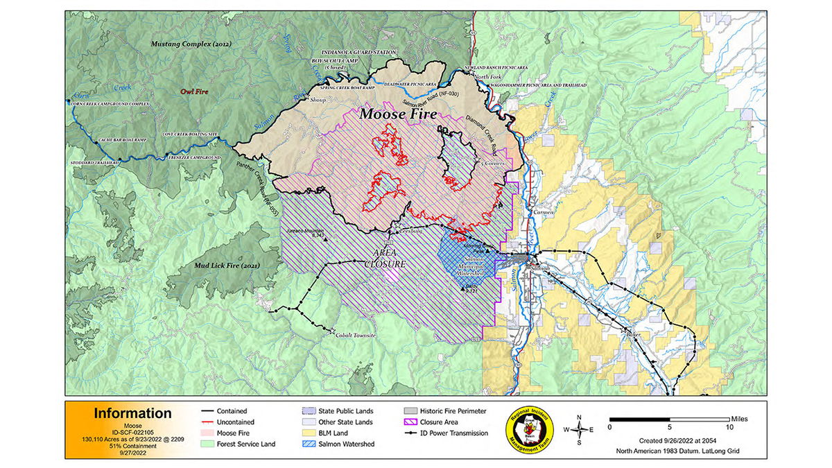
Moose Fire remains 51% contained

SALMON, Idaho (KIFI) - The human caused Moose Fire burning west and south of North Fork has burned 130,110 acres and is 51% contained.
On Monday, air resources flew over the fire to assess fire conditions. Air resources are available to engage hot spots and assist fire crew operations when safe to do so. The use of air assets is continually being evaluated by operations and the incident management team.
Fuel removal crews are utilizing heavy equipment to consolidate and relocate existing logs along powerlines to specified locations. Crews continue to remove residual slash created by previous suppression efforts away from containment lines. In addition, fire crews will continue to patrol the roadways along the Salmon River on the northwest flank of the burn area and perform road improvements where needed. Suppression repair is ongoing in numerous areas including along Ridge Road and near Leesburg. Resource Advisors (READs) will continue coordinating with operations personnel and private landowners in the area.
Dry weather will continue Tuesday, with moderate temperatures and light winds limiting fire growth. Crews continue to have lookouts in strategic locations.
Due to logging and slash removal in the powerline corridor east of Leesburg, a temporary power outage may occur in the coming days. Idaho Power is closely communicating with the incident management team and will alert affected customers.
EVACUATIONS
Zone 1 has been moved back to “READY” status. Evacuation zones 12, 13, and 15 remain in “READY” status. Beartrack Mine and Leesburg also remain in “READY” status. Evacuation status has been rescinded for Zones 2, 3, 4, 7, 8, 9a, 9b, 10, and 14. The Incident Management Team will continue to work closely with the Sheriff’s Office to consider changes to the evacuation status. Additional details are available at: Moose Fire Evacuation Zones.
CLOSURES AND RESTRICTIONS
A Salmon-Challis National Forest closure order was updated on September 19. It reduces the closure area lands north of Williams Creek and Deep Creek Roads, east of Panther Creek Road, and south of North Fork Ranger District/Salmon-Cobalt Ranger District. The closure includes national forest service lands pertaining to certain roads, trails, and a defined geographic area around the fire. See Moose Fire Emergency Area, Road, and Trail Closure, Order #04-13-22-512, for a complete description. This closure applies to hunting access, firewood cutting and gathering, fishing, hiking, camping, and other recreational activities.
- Public Lands north of the town of Salmon, south of Wallace Creek, and west of the Salmon River administered by the Salmon Field Office, Bureau of Land Management (BLM) are temporarily Closed.
- Currently, Stage 1 Fire restrictions are in effect on the Salmon-Challis National Forest, BLM, and State of Idaho lands in Custer and Lemhi Counties, excluding wilderness areas. These restrictions will end immediately after midnight (00:01) on Thursday, September 29, 2022.
- For more information about area hunting units, please visit the Idaho Fish and Game fire map: https://fishandgame.idaho.gov/ifwis/maps/realtime/fire/ or the Idaho Fish and Game Salmon Region Facebook page https://www.facebook.com/IDFG.salmon.


