Fish Creek Fire burns over 11,000 acres
TETON COUNTY, Wyo. (KIFI) - Fire managers for the Fish Creek Fire in the northeast corner of Teton County continue to battle the lightning-caused fire.
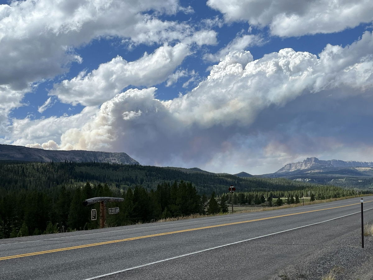
The fire is 22 miles east of Moran along US 26/287. The highway remains open, but drivers could experience smoke and limited visibility at times.
The fire has burned 11,397 acres and is 26 percent contained.
Below is the latest information on the fire from the Northern Rockies Management Team:
August 27, 2024
Northern Rockies Team 1, Incident Commander Brent Olson
Location: 7 miles SW of Togwotee Pass
Start Date: Friday, August 16, 2024
Cause: Lightning
Size: 11,397 acres
Percent complete: 26%
Resources: 364 Total Personnel: 10 Hand Crews; 13 Engines; 2 Dozers; 3 Heavy Equipment; 5 Helicopters
Key Messages:
A recording of yesterday’s community meeting has been posted on the Bridger-Teton National Forest Facebook page. We will post a notification when the next community meeting is scheduled.
This incident is being managed under a confine/point protection strategy. Confine is a wildfire response strategy of restricting a wildfire to a defined area, primarily using natural barriers that are expected to restrict the spread of the wildfire under the prevailing and forecasted weather conditions. Point protection may include the installation of pumps, sprinkler systems, vegetative fuels reduction, and other measures to protect identified values-at-risk. The “percent complete” figure associated with an incident refers to the degree to which these actions have been accomplished.
Current Status:
Yesterday, firefighters began installing a hose line on the indirect line from Highway 26 south to Pilot Knob and towards the Moccasin Basin Trailhead. Crews worked on Deception Road along with some equipment to reduce vegetative fuels and construct an indirect fire control line. North of the fire, crews started preparing the Holmes Cave Trail as an indirect line by clearing vegetative fuels. Precipitation and cooler temperatures kept fire activity subdued and provided firefighters an opportunity to continue the preparation of indirect fire line north of the active fire area. Structure protection crews continued to conduct assessment work needs for creating defensible space around structures including the installation of pumps, hose, and sprinklers where needed.
Firefighters will continue indirect line construction today in locations north and northeast of the fire with the intent of protecting the values at risk. Some specific locations where this work will continue include Deception Road, the Holmes Cave Trail, and Spread Creek tying into Flagstaff Road. Structure protection efforts are continuing along the Highway 26 corridor.
Weather and Fire Behavior:
It will be warmer and drier today as high pressure moves back into the area. Expect mostly sunny skies with winds out of the southwest and humidity levels dropping to 25 percent. An approaching system out of Canada will return increased southwesterly wind on Wednesday. Gusts to 30 mph and humidity below 30 percent will lead to elevated fire weather conditions.
Today will be a good drying day after yesterday’s precipitation event. Pockets of dead and down fuel will continue to burn with smoldering and creeping fire behavior. Primarily low flame lengths and rates of spread are likely today in the timbered areas still holding heat. Tonight’s forecasted poor relative humidity recovery may allow for a longer burn period than what has been typically observed.
Air Quality and Smoke:
Air quality and smoke conditions and forecasts can be found at https://www.airnow.gov/.
Closures and Evacuations:
A joint Closure Order for the fire area has been issued by the Bridger-Teton and Shoshone National Forests for public and firefighter safety. Please do not enter the closure area or use the Forest Roads that are closed.
The Fish Creek Area, Roads, and Trails Closure Order (map) has been established for public and firefighter safety in the fire area. Full details can also be found at https://www.fs.usda.gov/alerts/btnf/alerts-notices.
Fremont County: Brooks Lake, Pinnacle Drive and Breccia Drive area remain in the Level 2 Evacuation notice. A Level 2 Evacuation means “Be Set” to evacuate. You must prepare to leave at a moment’s notice. This level indicates there is significant danger to your area, and residents should either voluntarily relocate to a shelter or with family/friends outside of the affected area, or if choosing to remain, to be ready to evacuate at a moment's notice. See the alert notice on the Fremont County Fire Protection District Facebook page.
Teton County: The Teton County Division of Emergency Management utilizes a Ready, Set, Go www.tetoncountywy.gov/1846/Ready-Set-GO system for evacuation messaging. All residents should be in the Ready status by preparing for evacuations and becoming fire adapted.
US HWY 26/287 continues to experience smoke and sometimes limited visibility. Wyoming Department of Transportation (WYDOT) is working closely with Fremont County Emergency Management and fire officials for the safety of motorists and firefighters. Drivers are encouraged to visit https://www.wyoroad.info/ prior to traveling on US HWY 26/287 for road status and information, or download the Wyoming 511 app at https://www.wyoroad.info/511/WY511Mobile.html to monitor for any changes due to fire activity.


