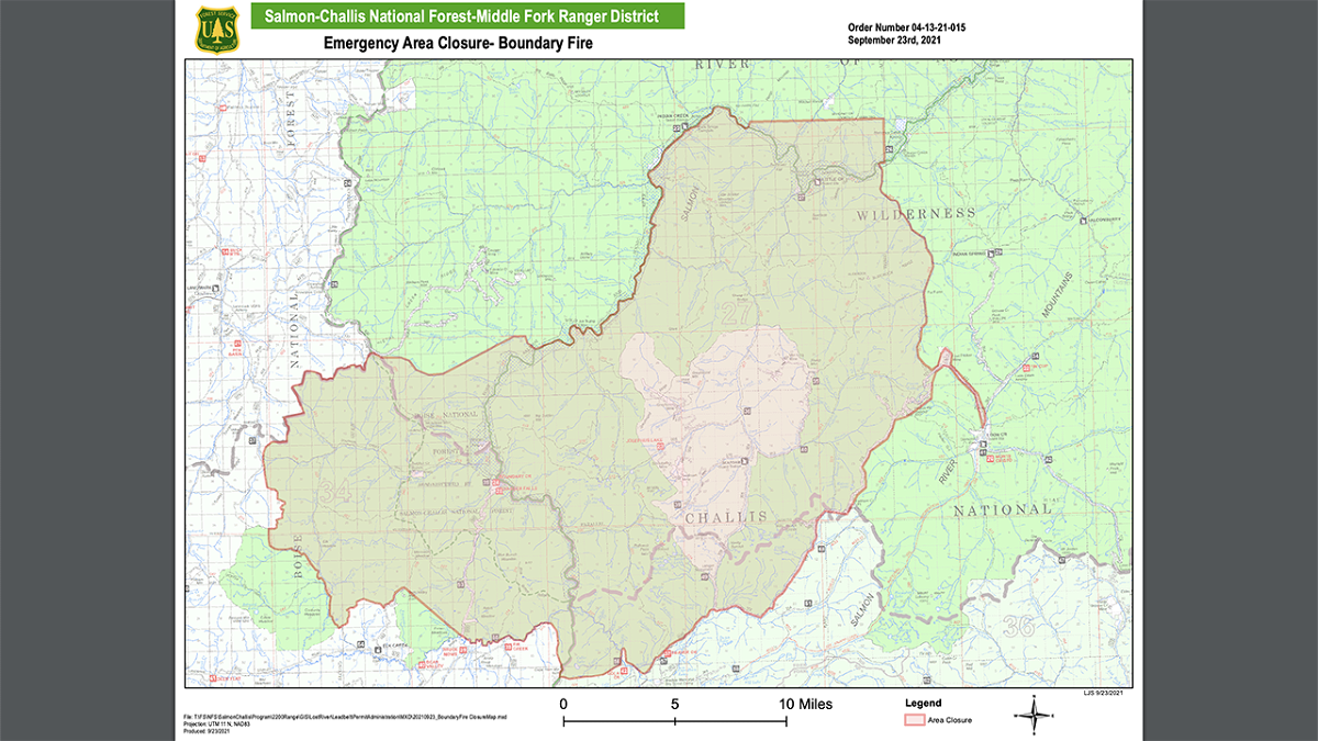
Boundary Fire Emergency Area, Road, and Trail closure reduced

SALMON, Idaho (KIFI) - The lightning caused Boundary Fire that started on August 10 has burned 79,856 acres and is 48% contained.
A point protection strategy is being applied to the Boundary Creek Fire. Firefighter and public safety remain the number one priority.
In the Sulphur Group, Boundary Creek recreation and administrative sites have been secured and all point protection
equipment has been removed. A small contingent of firefighters remain at Sulphur Creek Ranch as the fire is still active in a heavy snag patch on the south side of the ranch. Heat is still present on the southern perimeter of the fire, so crews are continuing fuel reduction work along the 579 Road.
Seafoam Group - Float Creek Bridge has been secured and the water handling equipment used to protect it has been removed and backhauled to base camp. The rain from Sunday abated the immediate threat to Seafoam Guard Station, but the pumps and hoses remain in place. Contingency plans are being considered for Lost Packer Mine and Loon Creek area.
Scarface Group - Middle Fork Ranch and the Little Creek Guard Station have been secured but will be patrolled for the next few days to check for smokes. Crews are assessing gear and equipment that can be backhauled. Cougar Creek Ranch was assessed for point protection needs in case winds push the fire closer to that property.
Pistol Group - Firefighters fortified and cleaned an existing hand line around Pistol Creek Ranch and Indian Creek
Guard Station. Pumps are being staged in preparation for a hoselay if needed to protect these values at risk.
The Salmon‐Challis National Forest has reduced the Boundary Fire Emergency Area, Road, and Trail Closure, Order Number: 04‐13‐21‐015.
Description of Closed Area, Roads, and Trails (#04-13-21-015):
Closed Area: All NFS lands in the Middle Fork District of the Salmon-Challis National Forest in the area bounded at the junction of the Frank Church River of No Return Wilderness Area (FCNOR Wilderness Area) boundary and National Forest System Road (NFSR) #550 Artillery Dome Road, then following the FCNOR Wilderness Area boundary south to the junction of National Forest System Trail (NFST) #4231 West Fork of Elk Creek Trail, then following NFST #4231 West Fork of Elk Creek Trail to its junction with the FCNOR Wilderness Boundary, then following the FCNOR Wilderness Boundary east to the junction of National Forest System Trail (NFST) #4028 Mountain Meadows Trail and NFSR #583 Bear Valley Mountain Lookout Road, then following a straight line southeast to NFSR #568 Dagger Falls Road, then following east and north along the FCNOR Wilderness Area boundary to its junction with NFSR #172 Beaver-Loon Road, then following the FCNOR Wilderness Area boundary along both side of NFSR #172 Beaver Loon Road to its junction with NFST #4115 Rat Creek Trail, then following the FCNOR Wilderness Area boundary on the north side of Lost Packer Mine to its junction with NFST #4011 Blue Lake Trail, the following NFST #4011 Blue Lake Trail and NFST #4004 Little Loon Trail to its junction with the Middle Fork of the Salmon River, then following a direct line north to its junction with Mahoney Creek, then following a straight line west to its junction with Middle Fork of the Salmon River, then following south and west on the Middle Fork of the Salmon River to its junction with Elkhorn Creek, then following east on Elkhorn Creek to the point of origin at the junction of the FCNOR Wilderness Area boundary and NFSR#550 Artillery Dome Road.
Closed Roads and Trails: All NFS roads (NFSR) and trails (NFST) within the Closed Area
The purpose of this order is to protect public health and safety from the effects of the Boundary Fire. Public and firefighter safety is the number one priority for the Boundary Fire.
This order will be in effect when signed and shall remain in effect until rescinded.


