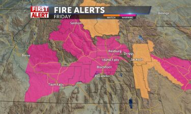
Hot and Windy; Red Flag Warning issued for Friday
A few thunderstorms, Thursday evening for areas of southeastern Idaho and western Wyoming. Overnight lows will fall to the upper 50’s to the lower…
Continue Reading A few thunderstorms, Thursday evening for areas of southeastern Idaho and western Wyoming. Overnight lows will fall to the upper 50’s to the lower…
Continue Reading
By Amir Vera, CNN It’s so hot across the globe, roads and roofs are melting. The deadly heat waves of the last week have sparked strange…
Continue Reading By Judson Jones, CNN Meteorologist New satellite images released by NASA Wednesday reveal the dramatic loss of water at Lake Mead due to the ongoing…
Continue Reading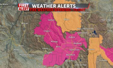
We are still under the influence of dry high pressure as winds will pick up tomorrow giving us a Fire Weather Warning, whereas conditions are…
Continue Reading By Aya Elamroussi, Dakin Andone and Amir Vera, CNN More than 85% of Americans are bracing for temperatures above 90 degrees Fahrenheit through the…
Continue Reading
Our hot weather pattern continues, with high pressure and a bit of monsoonal moisture working into the region from the south. For our Wednesday…
Continue Reading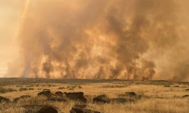
High pressure is running the show with low humidity today and a very slight chance of a southern staste line storm around Utah. Winds today move…
Continue Reading By Rachel Ramirez, CNN When Jane Gilbert was appointed last summer as Miami-Dade County’s first “chief heat officer” — and the…
Continue Reading By Robert Shackelford, Mike Saenz and Dave Alsup, CNN Some daily record high temperatures were set Tuesday and Wednesday across multiple states as…
Continue Reading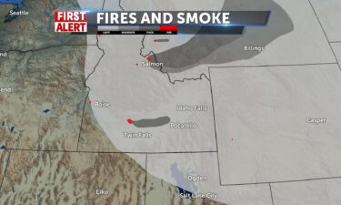
TUESDAY EVENING AND WEDNESDAY MORNING: Mostly clear with a few isolated thunderstorms in our SE mountains, with a low into the mid 50’s. Winds at…
Continue Reading By Jason Hanna and Christina Maxouris, CNN A dangerous heat wave that has wilted the south-central US spread across the country Wednesday, with about…
Continue Reading By Payton Major, Judson Jones and Amir Vera, CNN Heat alerts cover more than 20 states today and Wednesday across the Southern Plains and parts of…
Continue Reading By Payton Major, Judson Jones and Amir Vera, CNN Heat alerts cover more than 20 states today and Wednesday across the Southern Plains and parts of…
Continue Reading
Dry conditions are not helping fires from the Moose fire and Bray fire. Low humidity and very light shower chance with less wind today and patchy…
Continue Reading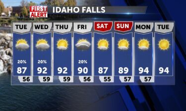
Wind Advisory until 8PM Monday evening, Red Flag Warning Until 9PM Monday evening. We have a cold front moving east this evening, winds will begin to…
Continue Reading By Jennifer Gray, CNN meteorologist Every year, hundreds of bold adventurers spend days or weeks in some of the harshest, most unforgiving conditions…
Continue Reading By Rachel Ramirez and Angela Fritz, CNN Hot-temperature records are far outpacing cool records across the globe this year as Europe and the United…
Continue Reading By Payton Major and Judson Jones, CNN More than 40 million people are under heat alerts across the Plains and Central California today and Tuesday as…
Continue Reading By Joseph Ataman, Jimmy Hutcheon, Xiaofei Xu, Zahid Mahmood, Sana Noor Haq, and Jorge Engels, CNN Extreme heat has engulfed parts of western Europe,…
Continue Reading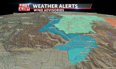
RED FLAG FIRE WARNING FOR VALLEY AND CENTRAL MOUNTAINS LAKE WIND AND WIND ADVISORIES AS WELL – GUSTS UP TO 50MPH WITH SUSTAINED WINDS OF 30MPH INTO…
Continue Reading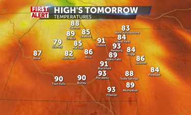
We will see mostly sunny skies for most of the region tomorrow with stray rain showers over the southern highlands, SE Idaho, and western…
Continue Reading Story by Reuters Authorities across southern Europe battled on Sunday to control huge wildfires in countries including Spain, Greece and France, with…
Continue Reading By Hannah Sarisohn Arizona’s governor has deployed the state’s National Guard to assist with flooding relief and mitigation over the…
Continue Reading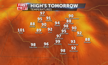
More stray thunderstorms will be present in the afternoon hours Sunday with most of the storms focused on the Snake River…
Continue Reading By Sana Noor Haq, CNN Commuters in London have been advised not to use the city’s transport network unless for “essential…
Continue Reading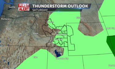
Highs well into the 90’s with isolated thunderstorms for both Saturday and Sunday. Highs on Sunday, could reach close to 100°, for areas in Snake…
Continue Reading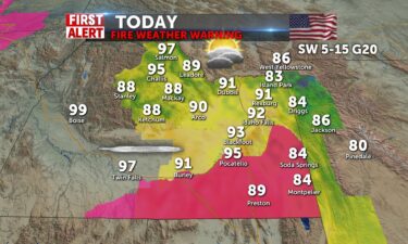
Moisture and heat give us an additional day for scattered thunderstorms into the southeastern highlands, including Pocatello and American Falls…
Continue Reading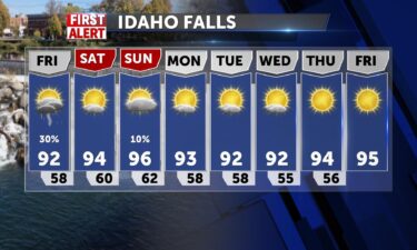
Hot and scattered storm threat continues We’re seeing a few thunderstorms Thursday evening with above average temperatures. OVERNIGHT: Partly cloudy…
Continue Reading By Payton Major and Angela Fritz, CNN Far from the drought-stricken West, where water is scarcer by the day and residents are cutting their usage,…
Continue Reading By Amarachi Orie, Taylor Ward, Niamh Kennedy, Mia Alberti, Al Goodman, Camille Knight and Amandine Hess, CNN New records have been set as…
Continue Reading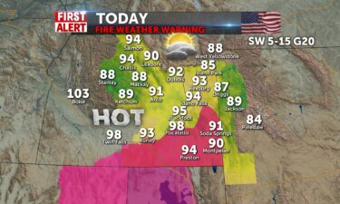
We’ll have another chance at afternoon thunderstorms today and that brings a possibility of fire weather especially for the area from the palisades…
Continue Reading By Aya Elamroussi, CNN Hot, dry weather conditions are making it harder for firefighting crews battling a wildfire in Yosemite National Park in…
Continue Reading By Aya Elamroussi, Michelle Watson and Alaa Elassar, CNN Everyone has been found after reports of more than 40 people missing in a rural Virginia…
Continue Reading By Claudia Dominguez and Brandon Miller, CNN About 44 people were unaccounted for Wednesday in the wake of severe weather and flooding across…
Continue Reading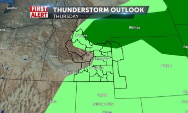
Hot and a little humid as more of the monsoonal moisture works in from the south. WEDNESDAY EVENING: Scattered thunderstorms and gusty winds. For the…
Continue Reading
High pressure to our north moves into Canada, and the high to the south from the four corners pushes east and a pacific low makes it way across…
Continue Reading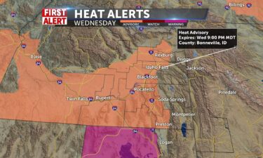
For our Tuesday night into Wednesday, we’re working on some monsoonal moisture working into the region from the south. We’ll look for increasing…
Continue Reading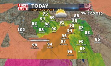
*HEAT ADVISORY IN EFFECT FROM 1 PM TO 9 WEDNESDAY… Hot conditions with highs of 92 to 98today and 93 to 100 tomorrow . Mountains communities will…
Continue Reading By Travis Caldwell, CNN With giant sequoias under threat from a wildfire spreading at Yosemite National Park in California, firefighters are in a…
Continue Reading By Travis Caldwell, CNN With giant sequoias under threat from a wildfire spreading at Yosemite National Park in California, firefighters are in a…
Continue Reading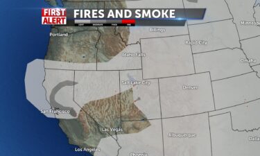
OVERNIGHT: Mostly clear with lows around lower to mid 50’s. With winds around 5-10 mph. TUESDAY: Sunny with highs into the mid to the upper 90’s,…
Continue Reading By Jennifer Gray, CNN Meteorologist While it seems strange to say this is a hot summer in Texas — because let’s face it, EVERY summer in…
Continue ReadingBy Jennifer Gray, CNN Meteorologist While it seems strange to say this is a hot summer in Texas — because let’s face it, EVERY summer in…
Continue Reading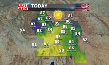
Our seasonal average is around 86 degrees for July. We hit 90 degrees yesterday and will keep temperatures in the mid-to-upper 80’s for the afternoon…
Continue Reading By Elizabeth Wolfe, Amanda Watts and Dakin Andone, CNN Fire crews are working to steer a growing wildfire away from Yosemite National Park’s…
Continue Reading By Elizabeth Wolfe, Amanda Watts and Dakin Andone, CNN Fire crews are working to steer a growing wildfire away from Yosemite National Park’s…
Continue Reading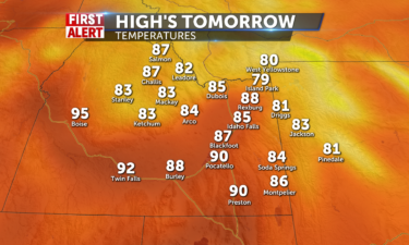
Mostly sunny skies are expected throughout the region with no rain in sight even around the region for…
Continue Reading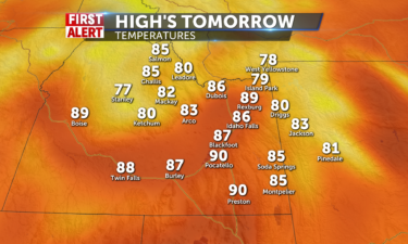
Mostly sunny skies will be across the entire region for Sunday with no more rain showers for central ID or anyone else around…
Continue Reading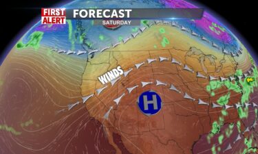
A few thunderstorms in central Idaho and the Snake Highlands Friday evening. OVERNIGHT: Partly cloudy with a low into the upper 50’s with winds at…
Continue Reading
Your weekend brings more heat and wind with highs even for the mountains, close to 90. Winds remain southwesterly from 10-20mph with gusts 20-30 into…
Continue Reading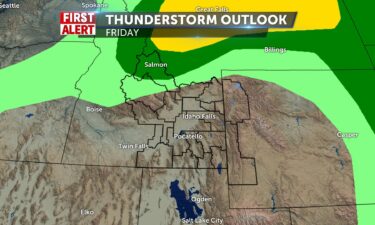
Above average highs into the 90’s for Friday and Saturday, with afternoon winds and a slight chance of thunderstorms. Slightly cooler on Sunday with…
Continue Reading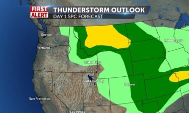
This first heat wave of the dog days of summer will be interrupted into the weekend with a slight drop in temperatures, 4-6 degrees. Before that…
Continue Reading By Payton Major, Taylor Ward and Monica Garrett, CNN The third heat wave of the still-early summer is scorching the US South, and “it will get…
Continue Reading By Payton Major, Taylor Ward and Monica Garrett, CNN The third heat wave of the still-early summer is scorching the US South, and “it will get…
Continue Reading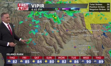
Highs into the 90’s with a few thunderstorms OVERNIGHT: Mostly clear with a few thunderstorms with a low into the upper 50’s. SW winds at 10-20 mph,…
Continue Reading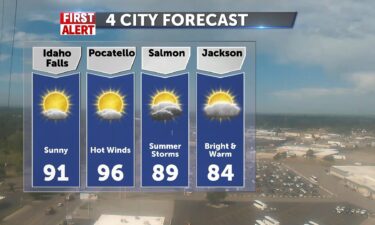
We’ll see scattered thunderstorms Wednesday for areas of Central Idaho and the upper Snake highlands through Clark County and Island Park and hot…
Continue Reading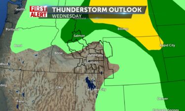
We’ll see scattered thunderstorms Tuesday evening and for Wednesday for areas of Central Idaho and the upper Snake highlands through Clark County and…
Continue Reading
Some mountain showers for Salmon, Challis, SW winds 5-15 with gusts to 20mph. Much like yesterday highs will be in the mid to upper 80’s. 86 in Idaho…
Continue Reading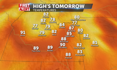
More isolated rain showers and thunderstorms are coming for central ID especially around Salmon and Challis in the afternoon…
Continue Reading By Jennifer Gray, CNN Meteorologist The focus across the US on this Independence Day will be on barbecues, celebrating, and being outdoors. However,…
Continue Reading By Jennifer Gray, CNN Meteorologist The focus across the US on this Independence Day will be on barbecues, celebrating, and being outdoors. However,…
Continue Reading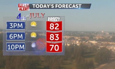
Our fourth of July forecast keeps temperatures close to normal as, seasonally, we expect temps in the lower 80’s for Idaho Falls. Sunny and breezy…
Continue Reading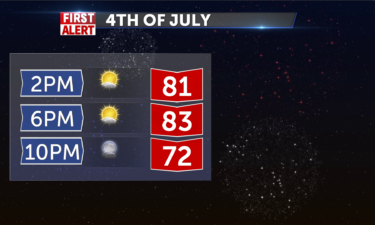
More isolated thunderstorms will line up for central ID around Salmon and Challis…
Continue Reading By Haley Brink, CNN meteorologist A serious warning has been posted by the National Weather Service office in Fairbanks, Alaska, this weekend,…
Continue ReadingBy Haley Brink Tropical Storm Colin dissipated over eastern North Carolina early Sunday, just 24 hours after becoming a named storm. Gusty winds,…
Continue Reading By Haley Brink Tropical Storm Colin dissipated over eastern North Carolina early Sunday, just 24 hours after becoming a named storm. Gusty winds,…
Continue Reading Story by Reuters Fresh evacuation orders were issued for thousands of Sydney residents on Monday after relentless rains flooded several suburbs in…
Continue Reading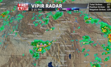
Isolated thunderstorms will stick around tomorrow, but only for central ID especially towards Salmon and…
Continue Reading By Jason Hanna and Haley Brink, CNN Tropical Storm Colin was blustering through coastal South Carolina on its way to North Carolina’s shores…
Continue Reading By Payton Major and Haley Brink, CNN As severe drought persists in the Southwest, cities are making tough decisions about their traditional firework…
Continue Reading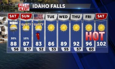
Thunderstorm risk, hot temps and gusty winds Friday afternoon and evening: Scattered thunderstorms especially for southeastern Idaho and Western…
Continue Reading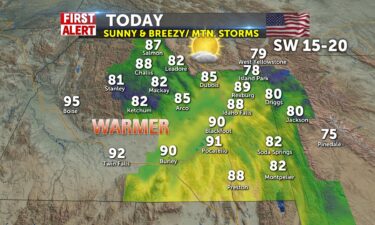
A lingering low makes for unstable conditions in the mountains with thundershowers and hot rains with possible heavy downpours and a chance of hail…
Continue Reading
We’ll head into warmer weather for this Friday and this weekend. We’ll see a few thunderstorms for southern and SE Idaho and SW Wyoming for Friday,…
Continue Reading By Payton Major and Monica Garrett, CNN Fourth of July weekend is approaching, and most of the United States will see rain chances through Monday. As…
Continue Reading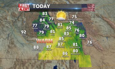
We’ve turned off the fans for today so less wind and more sun. Average temps for late June into July for Idaho Falls are at 81 degrees. We’ll will…
Continue Reading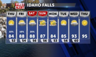
Winds are expected to die down a bit overnight, as this cold front exits the region. We’ll see a warming trend through the weekend, before another…
Continue Reading By Payton Major and Judson Jones, CNN It’s been a concerning hot and dry start to summer in southern Alaska. Anchorage is experiencing its…
Continue Reading High pressure over the area makes for more warm winds today SW 20-30mph. Highs will be around 83 for Idaho Falls and 85 for…
Continue Reading By Monica Garrett, CNN Meteorologist The Atlantic hurricane season is becoming more active with a disturbance set to drench coastal Texas this week,…
Continue ReadingBy Monica Garrett, CNN Meteorologist The Atlantic hurricane season is becoming more active with a disturbance set to drench coastal Texas this week,…
Continue Reading
We’ll see scattered thunderstorms Tuesday night into Wednesday morning with a cold front exiting the region. Look for slightly cooler temps for…
Continue Reading By Judson Jones, CNN Meteorologist At 8 a.m. ET Tuesday, two new supercomputers came online. These new computers, called Dogwood and Cactus, will…
Continue Reading
High pressure over the area makes for more heat today with SW winds shifting 20-30mph later. Highs will be approaching the low 90’s in Idaho Falls…
Continue Reading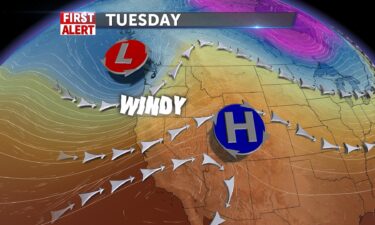
A few thunderstorms working into the Central Mountains and the Snake River Plain tonight. We’re seeing high pressure move slowly to the east,…
Continue Reading By Jennifer Gray, CNN Meteorologist We are nearly a month into the Atlantic hurricane season and the tropics are finally coming alive, as we suddenly…
Continue Reading By Rachel Ramirez Before the era of satellites, it was next to impossible to know whether a hurricane occurred out in the open ocean unless a ship…
Continue Reading High pressure over the area makes for more heat today with light winds shifting to the SW 5-10 and picking up tomorrow 20-30mph. Highs will be around…
Continue Reading
Mostly sunny skies will be across the region for…
Continue Reading
We’re seeing a few thunderstorms for Friday afternoon and evening, with weak surface cold front exiting the area. High pressure over the region will…
Continue Reading
A few straggling showers to the east and southeast push through with the last disturbance exiting our area. Gusty breezes to day with a Lake Wind…
Continue Reading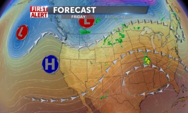
A few thunderstorms Thursday evening into Friday morning with gusty winds. High pressure will build back in for the weekend with hot and mostly sunny…
Continue Reading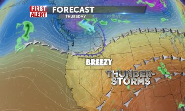
We’ll look for slightly breezy weather for Wednesday evening, with lows into the 40’s. Some clouds will roll in from the south for Thursday, along…
Continue Reading By Dave Hennen, Theresa Waldrop and Christina Maxouris, CNN More than 20 million Americans across 16 states were under heat alerts Wednesday as…
Continue Reading
We’ve got a bright day and warmer temperatures ahead this afternoon. N winds 5-15 with gusts to 20 into the afternoon. We have highs into the…
Continue Reading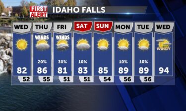
We’ll look for a breeze working through the region Wednesday afternoon. Warmer temperatures are expected, with our next chance of wet weather…
Continue Reading By Melissa Alonso, CNN A wildfire in southern New Jersey has grown to more than 13,500 acres in size, but is now 85% contained, the New Jersey Forest…
Continue Reading By Elizabeth Wolfe, Rob Shackelford and Theresa Waldrop, CNN It’s only the first day of summer, but almost 35 million people are under heat…
Continue ReadingHigh pressure brings another awesome day today. It will be warming up into the low to mid 70’s , in the mid 60’s for Island Park and Driggs. Light…
Continue Reading By Elizabeth Wolfe, Rob Shackelford and Theresa Waldrop, CNN It’s only the first day of summer, but almost 35 million people are under heat…
Continue Reading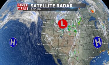
We’ll slowly see the thunderstorm threat clear overnight into Tuesday. Look for warmer weather and lighter winds. Our next round of scattered…
Continue Reading