
US is in for another heat wave, right on the heels of the last
By Jennifer Gray, CNN Meteorologist It’s hot. The official start to summer happens tomorrow, but it already feels like we are in the middle of…
Continue Reading By Jennifer Gray, CNN Meteorologist It’s hot. The official start to summer happens tomorrow, but it already feels like we are in the middle of…
Continue ReadingBy Elizabeth Wolfe, Robert Shackelford and Theresa Waldrop, CNN The persistent heat dome which imposed oppressively high temperatures on the northern…
Continue Reading By Elizabeth Wolfe, Robert Shackelford and Theresa Waldrop, CNN The persistent heat dome which imposed oppressively high temperatures on the northern…
Continue Reading By Michelle Watson and Susannah Cullinane, CNN A wildfire in southern New Jersey grew to at least 12,000 acres in size on Monday and is 70%…
Continue Reading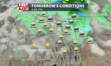
Isolated rain showers continue into the region for most of the day…
Continue Reading By Allison Chinchar, CNN Meteorologist More than 25 million people in over a dozen states are under heat alerts Saturday. From the northern Plains to…
Continue Reading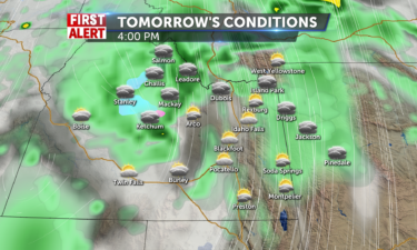
We will lookout for scattered and isolated thunderstorms for most of the region on Father’s…
Continue Reading By Allison Chinchar, CNN Meteorologist More than 25 million people in over a dozen states are under heat alerts Saturday. From the northern Plains to…
Continue Reading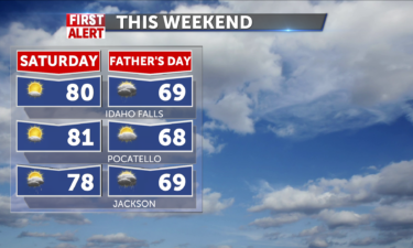
Isolated rain showers will be in the picture for western WY tomorrow in the afternoon. Everyone else will have mostly sunny skies throughout the…
Continue Reading By Claire Colbert and Raja Razek, CNN The devastating flooding that occurred along the Yellowstone River this week constitutes a 1 in 500-year event,…
Continue Reading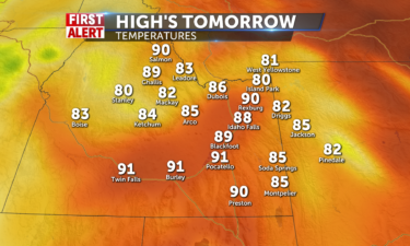
We will have mostly sunny skies throughout the region tomorrow with a small side of haziness. We might even see some stray rain showers during the…
Continue Reading By Judson Jones and Paul Murphy, CNN A vital bridge and road along the Yellowstone River and its tributary, the Gardner River, were destroyed by…
Continue Reading By Allison Chinchar and Monica Garrett, CNN Meteorologists More than 65 million people in over a dozen states are under heat alerts Thursday. From…
Continue Reading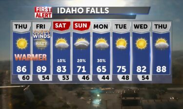
High pressure brings another awesome day today. It will be warm, in the 86-88 degrees and around 80 in Jackson. Light winds shifting to the SW 10-15…
Continue Reading By Aya Elamroussi and Andy Rose, CNN Several homes were damaged Wednesday by a tornado in central Wisconsin, officials said. The tornado was reported…
Continue Reading By Elizabeth Wolfe, Jason Hanna and Claudia Dominguez, CNN Yellowstone National Park could partially reopen as early as Monday as officials continue…
Continue Reading By Elizabeth Wolfe, Jason Hanna and Claudia Dominguez, CNN Yellowstone National Park could partially reopen as early as Monday as officials continue…
Continue Reading By Aya Elamroussi and Andy Rose, CNN Several homes were damaged Wednesday by a tornado in central Wisconsin, officials said. The tornado was reported…
Continue Reading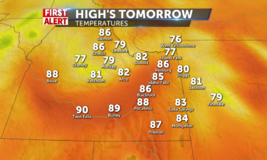
Mostly sunny skies will be present throughout the day tomorrow with no chances for any…
Continue Reading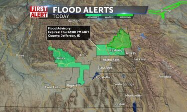
High pressure will take over and we’ll have light breezes today. Winds from SW 10-25+ mph with highs in the mid-to-upper 60’s. 66 in Jackson, 70’s in…
Continue Reading By Travis Caldwell and Joe Sutton, CNN Extreme heat is forecast again for a large swath of the US on Wednesday, testing power grids and leaving…
Continue Reading By Travis Caldwell, Joe Sutton and Steve Almasy, CNN At least 16 US cities set or tied records for their highest temperature for the date, with…
Continue Reading By Jason Hanna, Amir Vera, Elizabeth Wolfe, David Williams and Paradise Afshar, CNN While all entrances of Yellowstone National Park are temporarily…
Continue Reading By Jason Hanna, Amir Vera, Elizabeth Wolfe, David Williams and Paradise Afshar, CNN While all entrances of Yellowstone National Park are temporarily…
Continue Reading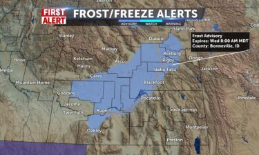
OVERNIGHT: Mostly clear and breezy with winds at 20-30 mph, with gusts over 35 mph. Overnight low temps into the mid 30’s. WEDNESDAY: Sunny and…
Continue Reading By Judson Jones, CNN Meteorologist Daily high temperature records were set across several cities Monday afternoon. Here are a few: — Columbia,…
Continue Reading By Elizabeth Wolfe, CNN In a matter of hours Monday, the iconic landmarks of Yellowstone National Park were shuttered to the public and its roads…
Continue Reading By Joe Sutton, CNN As Arizona’s Pipeline Fire has scorched nearly 23,000 acres, officials are discussing the possibility of closing the…
Continue ReadingBy Joe Sutton, CNN Arizona’s Pipeline Fire, about six miles from Flagstaff, has scorched more than 20,000 acres, about four times the area it…
Continue Reading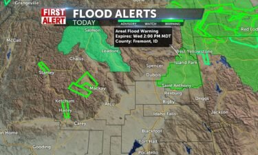
An area of low pressure moving through the region will continue to usher in gusty winds and a few showers for Tuesday. OVERNIGHT: A slight chance of…
Continue Reading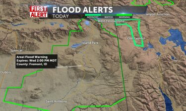
Wind Advisory for Snake River Plain and eastern Magic Valley through 9pm tonight. Flood warning for Fremont County in northern highlands of Idaho and…
Continue ReadingBy Allison Chinchar, CNN Meteorologist More than 25 million people in over a dozen states are under heat alerts Saturday. From the northern Plains to…
Continue Reading By Judson Jones, CNN Meteorologist This is exceptionally hot and humid for any time of year. Period. “We don’t change our criteria based…
Continue Reading
Click here to vote for June’s…
Continue Reading By Elizabeth Wolfe, Joe Sutton, Ella Nilsen and Brandon Miller, CNN A wildfire burning just six miles north of Flagstaff, Arizona, has prompted…
Continue Reading By Joe Sutton and Susannah Cullinane, CNN Mandatory evacuations are in place after a wildfire expanded steadily in Southern California’s…
Continue Reading By Joe Sutton and Susannah Cullinane, CNN Mandatory evacuations are in place after a wildfire expanded steadily in Southern California’s…
Continue Reading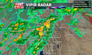
Heavy rain showers are currently working their way through the region and will continue to be with us heading into the overnight to early morning…
Continue Reading By Haley Brink and Allison Chinchar, CNN Meteorologists More than 65 million people from California to Tennessee are under some type of heat alert…
Continue Reading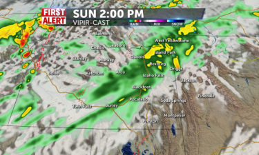
Scattered rain showers and thunderstorms will hit all of eastern ID and western WY tomorrow especially in the afternoon and evening…
Continue Reading By Haley Brink and Allison Chinchar, CNN The official start of summer is 10 days away but more than 60 million Americans are under heat alerts…
Continue Reading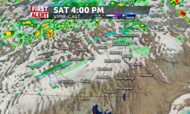
OVERNIGHT: Mostly clear and breezy, with a low into the mid to the upper 50’s. South wind 15 to 20 mph, gusts as high as 30 mph. SATURDAY: Mostly…
Continue Reading By Allison Chinchar, CNN Meteorologist Over 35 million people are under heat advisories or excessive heat warnings from California to Texas, as the…
Continue Reading
Still loving the jet stream and high pressure to the south with winds picking up SW 15-30+mph, sunny and dry. Highs in the mid to upper 80’s. Upper…
Continue Reading By Stephanie Elam, CNN As the extended drought has left vegetation dry, brittle and ripe for burning, fire officials in Southern California are…
Continue Reading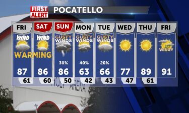
High pressure to our south will deliver warmer temperatures locally, before cooler, wet weather arrives this weekend. OVERNIGHT: Partly cloudy with a…
Continue Reading By Pedram Javaheri and Allison Chinchar, CNN meteorologists The two largest fires in New Mexico history are happening simultaneously and are only…
Continue Reading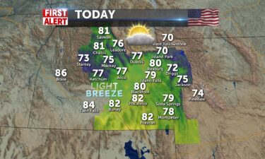
High pressure and warm jet make for a sunny day and temps close to 80 and above for most of the valley. @80 for Idaho Falls and 82 for Pocatello.…
Continue Reading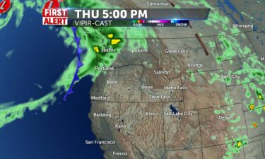
We have some moisture working through the region, with a few isolated thunderstorms this evening. We’re looking for warmer weather for Thursday,…
Continue ReadingBy Judson Jones, CNN Meteorologist A “dangerous and deadly heat wave” is on the way for the Southwest through the weekend, the Phoenix…
Continue Reading By Judson Jones, CNN Meteorologist A “dangerous and deadly heat wave” is on the way for the Southwest through the weekend, the Phoenix…
Continue Reading
High pressure and the jet stream push us into the mid-to-upper 70’s today with mostly sunshine and some high cloudiness across the region. Storm…
Continue Reading
We’re looking for warning temps and a few isolated thunderstorms. Temperatures will increase everyday through Saturday, before cooler and wet weather…
Continue Reading
We’ll be headed into much warmer weather this week as the jet pushes north and protects us from approaching pacific systems. Mountain showers are in…
Continue Reading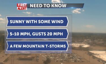
We’ll see a few thunderstorms Monday evening, with a low risk of mountain thunderstorms for Tuesday. High pressure to our south will slowly warm us…
Continue Reading By Judson Jones, CNN Meteorologist Intense summer heat will build as the week rolls on, peaking with potentially deadly heat in the drought-stricken…
Continue ReadingA trough spinning from a low to our west will yield windy conditions and more sun for today. Showers ease out especially from the southern valley…
Continue Reading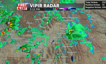
More heavier rain showers and thunderstorms are on the way for tonight continuing all the way into late tonight until about 1am.…
Continue Reading By Haley Brink, CNN meteorologist The central Plains could see severe weather Sunday, according to the National Weather Service’s Storm…
Continue Reading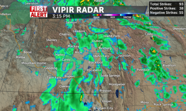
We will have scattered light rain showers in the morning hours followed by isolated heavy thunderstorms for the late afternoon and evening hours for…
Continue Reading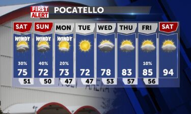
SATURDAY: A chance of showers and thunderstorms with mostly cloudy skies, highs into the lower 70’s with winds at 15-35 MPH. Saturday night,…
Continue Reading SATURDAY: A chance of showers and thunderstorms with mostly cloudy skies, highs into the lower 70’s with winds at 15-35 MPH. Saturday night,…
Continue Reading
High pressure to our south will deliver warm temperatures for Friday. A chance of showers and thunderstorms, today, mainly in highlands and mainly…
Continue Reading
High pressure to our south will deliver warm temperatures for Friday. However, that ridge of high pressure isn’t sticking around, as an area of low…
Continue ReadingBy Judson Jones, CNN Meteorologist Before hitting Florida on Saturday, a broad swath of showers and thunderstorms over the Yucatán Peninsula could…
Continue Reading By Judson Jones, CNN Meteorologist Before hitting Florida on Saturday, a broad swath of showers and thunderstorms over the Yucatán Peninsula could…
Continue Reading
High pressure is helping us out to make up for the lousy Memorial Day weekend. Normal highs this time of year in Idaho Falls around 72 and we’ll be…
Continue Reading
OVERNIGHT: A few thunderstorms close to the Montana state line, with mostly cloudy skies for the rest of us. Lows into the mid 40’s for the Snake…
Continue Reading By Jennifer Gray, CNN As Wednesday marks the beginning of hurricane season, the tropics have seemed to get the memo as well. The first real sign of…
Continue Reading By Jennifer Gray, CNN As Wednesday marks the beginning of hurricane season, the tropics have seemed to get the memo as well. The first real sign of…
Continue Reading
Warmer weather for Wednesday and Thursday High pressure will work in for Wednesday, with a warming trend before our next storm system arrives…
Continue Reading
We’re looking for some lingering thunderstorms and showers for Tuesday evening. High pressure will work in for Wednesday, with a warming trend before…
Continue Reading By Judson Jones, CNN Meteorologist After making landfall Monday afternoon as a Category 2 hurricane just west of Puerto Angel, Mexico, Agatha rapidly…
Continue Reading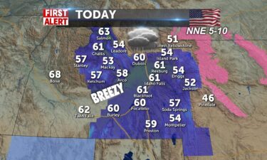
Another dreary day with sloppy rains and a good chance of storms, as the last part of the Memorial Day trough eases out of here. Highs today with…
Continue Reading
An upper level area of low pressure will settle into Southern Idaho and Northern Nevada for Monday evening. For Tuesday, look for more of…
Continue Reading
A weak trough is gonna slide through today and cover us with cold rains and mountain snows through the night. Highs will be influenced with cold…
Continue Reading By Jennifer Gray, CNN Even two years later, Yolanda Tezeno’s voice quivers as she describes the day she returned to her Louisiana home…
Continue Reading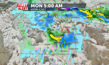
Scattered mountain snow showers and valley rain showers and thunderstorms continue throughout the day for Monday on Memorial…
Continue Reading By Taylor Ward and Haley Brink, CNN Meteorologists Agatha was downgraded to a tropical storm late Monday after making landfall in southern Mexico as…
Continue Reading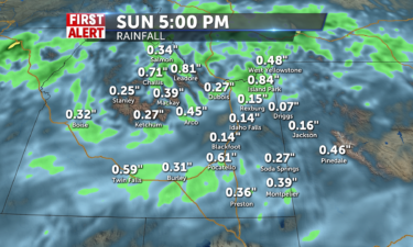
Rain showers continue into the day tomorrow throughout the whole…
Continue Reading By Haley Brink, CNN meteorologist Tropical Storm Agatha has formed to become the first storm of the 2022 eastern Pacific hurricane season. Agatha has…
Continue Reading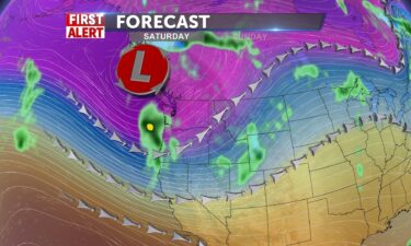
Scattered showers with gusty winds as an area of low pressure settles into the region for this weekend. FRIDAY NIGHT: A chance of showers and…
Continue Reading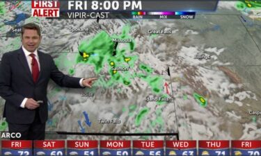
FRIDAY: A chance of showers and thunderstorms with partly cloudy skies. Highs into the mid to upper 70’s. Southwest winds 10-15 MPH, increasing to…
Continue Reading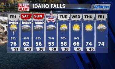
Verified High temps yesterday set records in #pocatello 90 degrees! Idaho Falls airport #ida#idahjofallsairport hit 87 degrees.…
Continue Reading By Judson Jones, CNN Meteorologist Many see Memorial Day weekend as the unofficial start of summer. But, if you are planning outdoor events, you may…
Continue Reading
Thanks to a dome of high pressure ( can you feel it ?) we’ll experience the warmest day of the year today. Highs will spike into the mid-to-upper…
Continue Reading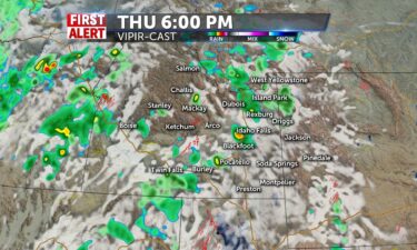
OVERNIGHT: Mostly clear with a low into the mid 40’s, with winds at 15-25 MPH. THURSDAY: Increasing clouds through the day, with a chance of showers…
Continue Reading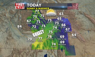
Sunny and warmer the next couple of day with highs jumping above average for late May (70) to 75-77 degrees today and even warmer tomorrow, mid 80’s,…
Continue Reading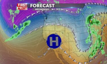
High pressure over the west will move through the region Wednesday and Thursday. We’ll see mostly sunny skies for Wednesday with a few thunderstorms…
Continue Reading By Jennifer Gray, CNN meteorologist The official start to hurricane season is just a week away and forecasters are predicting another busy one. The…
Continue Reading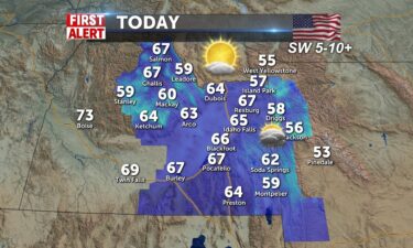
A trough may kick up a shower for some and high pressure is going to influence the next several days with clearing conditions and warmer temps. SW…
Continue Reading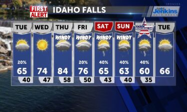
OVERNIGHT: Chance of thunderstorms with lows into the mid to upper 30’s, winds at 10-15 MPH. TUESDAY: Partly to mostly cloudy with a thunderstorm…
Continue ReadingBy Jennifer Gray, CNN meteorologist Leading up to the holiday weekend, there will be some dire weather hitting portions of the US, including more…
Continue Reading By Jennifer Gray, CNN meteorologist Leading up to the holiday weekend, there will be some dire weather hitting portions of the US, including more…
Continue Reading
Chilly start with frost and fog and heading into the upper 50’s and lower 60’s. SW winds 5-10mph and increasing cloudiness. Ridge pushes in and we’ll…
Continue Reading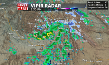
Isolated rain and snow showers will be present for the mountains tomorrow with a chance of a stray shower getting into the…
Continue Reading By Allison Chinchar, CNN meteorologist More than 10 million people remain under a heat advisory for Sunday across the Northeast as record…
Continue Reading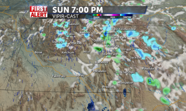
More mountain snow showers will be in store for the mountains of central ID and western WY with a few stray rain showers and thunderstorms possibly…
Continue ReadingBy Aya Elamroussi, Paradise Afshar, Andy Rose and Alaa Elassar, CNN Two people are dead after a powerful tornado ripped roofs off buildings and…
Continue Reading By Allison Chinchar, CNN meteorologist More than 20 million people remain under a heat advisory for Sunday across the Northeast as record…
Continue Reading