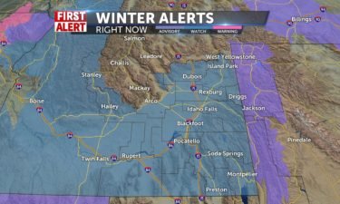
Cold Friday, Winter Storm Watch for Saturday
Cold and breezy with a few scattered snow showers Thursday night. Clearing skies for Friday morning with a COLD start to the day. Several…
Continue Reading Cold and breezy with a few scattered snow showers Thursday night. Clearing skies for Friday morning with a COLD start to the day. Several…
Continue ReadingWinds and continued chances for snow showers will carry us through the day Thursday. Calmer but colder conditions are expected…
Continue Reading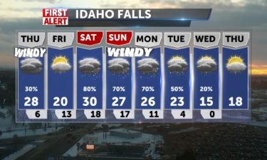
Staying windy with a few rain and snow showers for Thursday. Clearing out for Friday morning, before another snow storm arrives this weekend.…
Continue ReadingAbove average temperatures will usher some rain into the region, along with snow and wind as a cold front pushes through…
Continue Reading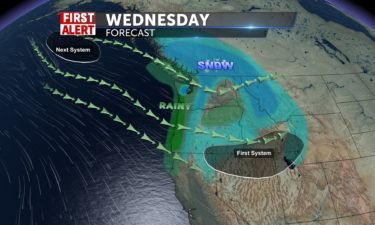
A cold front is moving through for Wednesday with gusty winds, scattered snow and rain showers. Look for highs into the lower to mid 30’s for the…
Continue Reading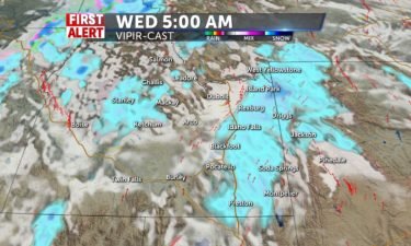
Partly cloudy and breezy with stormy weather on the way for Wednesday and Thursday. We’ll see gusty winds with 1-3″ of new snow possible for the…
Continue ReadingWind speeds beyond 20 mph are expected throughout the Snake River Plain for the next couple of days. Chances for snow pick up throughout the region…
Continue Reading
Snow for Sunday – Accumulation of 1-2″ inches possible into the Upper Snake Plain. Windy conditions continue as the next trough pushes across Idaho.…
Continue Reading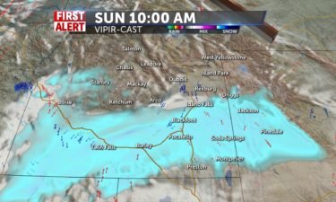
A cold front will arrive this Saturday with gusty winds and snow showers. A second system pushes in for Sunday, with snowfall possible in the Snake…
Continue ReadingWe’ll see calm conditions Friday, with some active weather on the way for the…
Continue Reading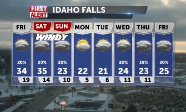
Light snow possible for Friday with partly to mostly cloudy skies overhead for the Snake River Plain and our eastern mountains. A cold front slides…
Continue Reading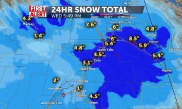
As expected, a winter storm rolled into the region early Wednesday morning. Idaho Falls and Ammon saw anywhere from 4-7″ of fresh snowfall. Most of…
Continue Reading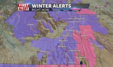
Travel could be difficult at times through Wednesday as another winter storm moves into eastern Idaho and western Wyoming.…
Continue Reading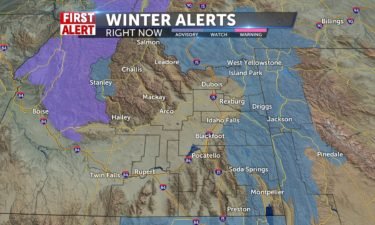
Another Winter storm is on the way for Tuesday night and Wednesday. The National Weather Service has issued Winter Storm Watches for the higher…
Continue ReadingTuesday will see a chance for snow flurries under mostly cloudy skies, with the storm’s main impact hitting over-night into New Year’s…
Continue ReadingWe’ll start the week under calm conditions, with an impressive storm on the way just in time to hail in the new…
Continue Reading Partly Sunny tomorrow, with highs in the 20’s after a cold night in the area. Winds NE 5-10, that will make lows feels like temps are around 0 or…
Continue Reading Very frigid temps are here again tonight, with lows from 3-8 degrees, and -11 in Jackson, and wind chills will make it feel as low as -25. Highs rise…
Continue Reading After freezing drizzle and snow flurries Friday, some remaining light snow takes us into Saturday, then Sunday, more moisture drives snow with little…
Continue Reading High pressure gives us cloudy conditions to start Friday and lows in the single digits. Highs in the 20’s with a few lingering snow showers into…
Continue ReadingThe next couple days will see single digit lows, and highs right around 20…
Continue ReadingStorms are calming down into Christmas day. We’ll look for partly cloudy skies and colder temperatures through the rest of the…
Continue ReadingWe’ll look at continued chances for some wet holiday weather as we move into Christmas…
Continue ReadingSnow will push through the region tonight, moving into the daytime hours Christmas Eve. Colder temps on the…
Continue ReadingTemperatures will be well above average for your Monday, just ahead of a holiday…
Continue Reading Snow chances for Christmas Eve from Jackson to IF @50% with 1-3″ possible for the Snake River Plain. Above average temps with some windy conditions…
Continue Reading
High pressure building over the region will bring us a nice weekend for December with warming temps. A weak system is expected to move in on Monday…
Continue ReadingThe weekend will see some sunshine, and temperatures nearing 40 degrees before we see a cool-down and some storms into next…
Continue Reading
A slight risk of snow moves through the region for Friday, with warming temps for this weekend. Most of the snow will push though Northern Idaho and…
Continue ReadingA weak storm system moves over the region for your Thursday and Friday, with very low impact beyond cloudy…
Continue Reading
A storm system is moving through the west, with most of the snow and rain favoring Washington, Oregon and Northern Idaho. Southeastern Idaho and…
Continue ReadingWe started of Wednesday with wind chill factors below zero, but conditions will warm into the weekend, with chances of snow Thursday and…
Continue Reading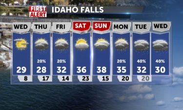
Quiet weather for Wednesday before our next system swings in for Thursday and Friday. Currently, most of the snow is projected to hit mostly into the…
Continue ReadingTuesday and Wednesday will bring a little more sunshine into the forecast, ahead of storms expected to close out the work…
Continue Reading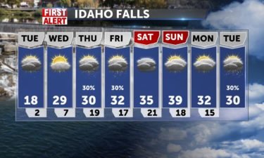
Cold air, patchy fog, low cloud cover for the Plain with a few flurries. We’ll see many low temperatures close to zero, with many spots going…
Continue Reading
After scattered snow showers pushing through late Sunday, we’ll get some colder air in place to drop temps to single digits and even negatives in…
Continue Reading
Scattered snow showers in the forecast to start off the weekend. Clearing as we move into next week, with dropping temperatures. Saturday, we’ll see…
Continue ReadingExpect morning fog as a possibility through the first half of the work week. Otherwise calm conditions are expected between now and some Wednesday…
Continue Reading Low Clouds and some patchy fog start the week. We’ll have an overcast Monday – highs from around 30-46, teens overnight from IF to mountains, before…
Continue ReadingSnow activity will taper out over the weekend, leaving behind a much colder air-mass for next…
Continue Reading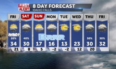
Scattered snow and rain showers for Thursday night and Friday morning. We’ll look for a little clearing in the Plain with partly cloudy skies. We’ll…
Continue Reading We’ll see continued chances for a mix of rain and snow throughout the region for your…
Continue ReadingWe’ll see continued chances for a mix of rain and snow throughout the region for your…
Continue Reading
More snow and rain on the way for Thursday. Look for scattered showers to take hold of the region for the rest of the week. Idaho Falls could…
Continue ReadingWe’ll see this weeks first glimpse of snow Wednesday, with more significant storms coming in the next couple of…
Continue Reading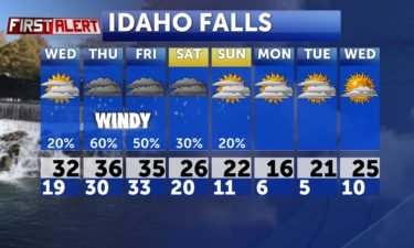
Look for a few scattered snow showers for Wednesday with more rain and snow showers for Thursday. WINTER STORM WATCH IN EFFECT FROM EARLY THURSDAY…
Continue ReadingExpect clear conditions Tuesday, with a low impact storm headed your way Wednesday. More significant activity picks up Thursday and carries us into…
Continue Reading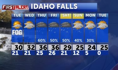
Patchy overnight and early morning fog, with clearing skies in the afternoon for Tuesday. A brief shot of show passes through on Wednesday, with a…
Continue Reading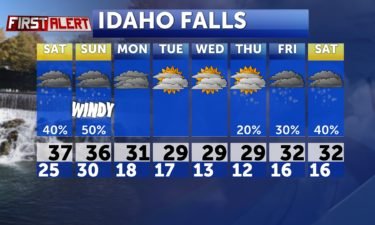
A storm system is moving through the region this weekend with scattered snow showers arriving this Saturday afternoon. Most of the snow will fall…
Continue Reading Areas of Fog and Clouds dominate your Friday forecast. 40-50% chance of snow/rain kickoff the weekend with some accumulations possible. Several…
Continue ReadingMostly cloudy conditions are expected Thursday and Friday ahead of weekend snow…
Continue Reading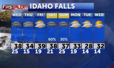
Flurries and freezing drizzle overnight and into Wednesday for the Snake River Plain and Western Wyoming Valleys. Central Idaho will see mainly sunny…
Continue Reading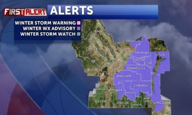
Scattered snow and freezing drizzle tonight and Tuesday morning, with a band of wet weather sliding in from the Southwest. The National Weather…
Continue ReadingSnow showers will continue throughout the day Monday. Overcast skies will continue through the rest of the week, with just light chances for…
Continue Reading Another round of scattered snow showers will arrive late Sunday and into Monday. Accumulations around the Snake River Plain and some valleys should…
Continue Reading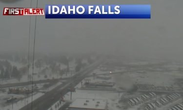
Lingering snow showers Friday night and a few showers/flurries for Saturday, as this system moves away. The Winter Weather Advisories will expire…
Continue Reading Scattered snow showers for the next couple of days with highs into the lower to mid 30’s. Wednesday night, look for scattered snow showers. Lows into…
Continue ReadingEastern Idaho will likely see snow over the next 3 days. It will be an extremely active weather pattern throughout the next few days. Several…
Continue Reading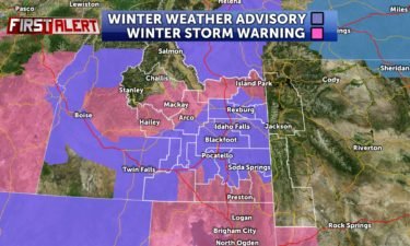
Winter Weather Advisories and Winter Storm Warnings have been posted for Idaho and Utah. WINTER WEATHER ADVISORY REMAINS IN EFFECT FROM 5 AM…
Continue ReadingThe main snow event is expected to hit the area on Wednesday and Thursday. Tuesday afternoon expected scatters snow showers and gusty winds up to 25…
Continue Reading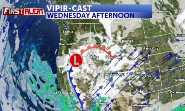
Main snow event hitting the area Wednesday and Thursday Fairly quiet Tuesday before a Pacific system swings in for the holiday. We’ll see scattered…
Continue Reading A very active pattern starting early Monday. Scattered snow showers will begin to move into the region mid Monday morning, with more…
Continue Reading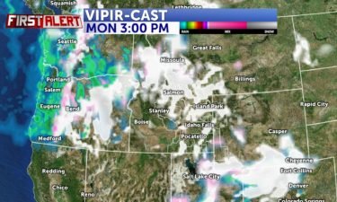
We’re looking for a pattern shift to arrive Sunday, which will bring in dropping temps and scattered snow showers all throughout this approaching…
Continue Reading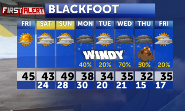
Cloud cover will move in for the weekend, ahead of widespread snowstorms starting…
Continue Reading Clearing and quiet weather for Friday, thanks to some high pressure over the Northwest. That high will quickly break down this weekend as cloud cover…
Continue Reading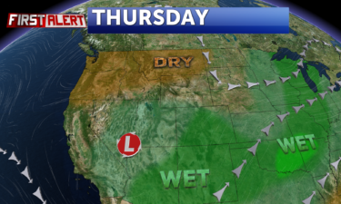
Storms will be holding off through the rest of the week, with more active weather expected into next…
Continue Reading
A deep upper level low over California is delivering the risk of some scattered snow and rain showers Wednesday night and early Thursday. We’ll begin…
Continue ReadingThe Snake River Plain will watch for some evening snow showers to spill over from the Eastern Highlands…
Continue Reading Look for a chance of snow showers rolling back in from the Southeast Wednesday afternoon and night. Heavy snow possible for the mountains around Bear…
Continue Reading A cold front arrives for Tuesday with afternoon winds and a few scattered rain and snow showers. Some showers will linger into Wednesday, with…
Continue ReadingA warm start to the week will give way to active weather Tuesday and…
Continue ReadingTemperatures will trend toward 60 degrees Friday, ahead of a cold…
Continue Reading Winds pick up for Friday as a storm system swings in from the north. There will be a few showers for Central Idaho, Island Park, Yellowstone, Jackson…
Continue Reading We’ll look for high pressure to work in from the south, bumping up our temps and clearing our skies for Thursday. Our next threat for stormy weather…
Continue Reading A few isolated showers Tuesday night and early Wednesday, mainly for the higher elevations. We’ll look for high pressure to work in from the south,…
Continue Reading
Another system slides into the northwest on Tuesday with afternoon clouds for our region and a slight chance of rain/snow for Central…
Continue Reading A weak disturbance can be seen in our local mountains with a slight chance of snow. Mostly cloudy and breezy for the rest of us for Sunday night and…
Continue Reading High pressure still with us for Saturday with warmer temperatures. The Next storm is dropping along The Continental Divide for Sunday with a slight…
Continue Reading High pressure with slightly warmer temperatures arriving for Friday and Saturday. Look for a slight chance of snow working into the mountains for…
Continue Reading Slightly cooler temps for Thursday as we pull in the cooler air from the Northwest.…
Continue Reading High pressure keeping us dry and mainly sunny for the Snake River Plain. We’ll continue to see some stormy weather to the east. Look for above…
Continue Reading High pressure keeping us dry and mainly sunny for the Snake River Plain. We’ll continue to see some stormy weather to the east, which could put down…
Continue Reading A Ridge of High Pressure makes for warmer temps and sunn skies for the region into the first week of…
Continue Reading We’re moving into a quiet period of weather, with the only exception is a slight chance of snow Sunday and Monday for areas in Western Wyoming and…
Continue Reading A system passing through Montana and Central Wyoming is sending cloud cover and a few snow showers in our direction.…
Continue Reading Patchy freezing fog overnight, otherwise sunny and cold. A slight chance of snow through Wyoming.…
Continue Reading Clearing and cold weather for the next couple of days, as our stormy weather exits the region. Look for lows close to zero for the Snake River Plain…
Continue Reading A cold front from the north is ushering in frigid conditions and gusty winds for Eastern Idaho and Wyoming. We’ll also have a chance of snow showers…
Continue Reading Another Cold front will push through late Monday into Tuesday morning and arctic air behind the front will create another taste of winter for…
Continue Reading A cold front is on the way for Saturday. We’ll see gusty winds and a few showers for Saturday. After the cold front exits the region, a cold blast of…
Continue ReadingMild and sunny with highs into the mid 50’s with increasing winds before a cold front slides in for Saturday. We’ll see gusty winds and a…
Continue Reading We’ll have a few mountain showers for Wednesday, but a clearing forecast for the rest of us with mostly sunny skies. We’ll see…
Continue Reading Another cold front will slide in for Tuesday. We’ll see gusty winds with a few snow and rain showers. Sunny skies will set in for most of the…
Continue Reading After some rounds of wild weather Saturday, including severe thunderstorms in American Falls and Pocatello areas, everyone got a glimpse of some…
Continue Reading Stormy weather moving through this weekend. Look for dropping temperatures, gusty winds and rain/snow showers for Saturday. We’ll have some…
Continue Reading The first cold front is sliding through for tonight with gusty winds and dropping temperatures. We’ll see dry and windy weather for Friday,…
Continue Reading Windy weather for Wednesday as a cold front approaches for This weekend. Wednesday: Mostly sunny with highs into upper 60’s. Windy, SW winds…
Continue Reading Calming winds heading into Tuesday as high pressure builds in for the mid-week. We’ll see warmer weather, with mainly sunny skies. By Thursday,…
Continue Reading