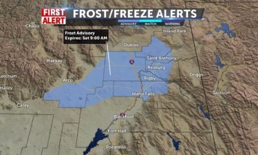
Frost Advisory with sunny skies Saturday
A few showers and gusty winds for Friday evening, with clearing skies into Saturday. With the exiting the system, we’ll have chilly overnight lows.…
Continue Reading A few showers and gusty winds for Friday evening, with clearing skies into Saturday. With the exiting the system, we’ll have chilly overnight lows.…
Continue Reading
A chance of t-storms through tonight with lows in the 30’s, but above freezing. Frost Advisory for the northern Snake River Plain. Mix of clouds and…
Continue ReadingShowers an thunderstorms will effect the area once again, Friday afternoon. Skies will clear into Saturday, and temperatures will rise toward…
Continue Reading
An area of low pressure over Oregon, is moving east into our region for Friday. We’ll see isolated showers and thunderstorms, gusty winds and cool…
Continue ReadingExpect another active afternoon, with scattered showers and a few isolated thunderstorms. Unsettled conditions will continue through Friday, with…
Continue Reading
Gusty winds and scattered thunderstorms continue, as an area of low pressure moves in from the northwest. The low clears to the east for the for the…
Continue ReadingBreezy conditions are expected again, today. More thunderstorms are possible by this evening. Temperatures have cooled a few degrees each day this…
Continue Reading
Gusty winds with a few showers will continue Tuesday night. An area of low pressure off the west coast, continues to send scattered showers and gusty…
Continue ReadingAnother round of active weather is effecting the area, Tuesday. Expect a windy afternoon, with thunderstorms by this…
Continue Reading
An area of low pressure off the coast is sending waves of showers and thunderstorms this week. We’re looking to pick up more showers, gusty winds and…
Continue ReadingAn unsettled forecast is moving in for the next couple of weeks. Expect on and off chances at thunderstorm activity. Temperatures will cool back down…
Continue Reading Showers moving in for Monday with thunderstorms in the afternoon, highs in the upper 70’s, possible 80 in the lower SRP. Highs in the 50’s by…
Continue Reading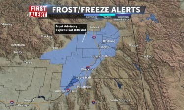
A storm is sweeping through central Wyoming Friday night, dropping in a few showers in far Eastern Idaho and Western Wyoming. We’ll still have some…
Continue ReadingClear conditions will dominate the forecast through the weekend. Expect high temperatures to warm toward mid-seventies by Mothers Day, Sunday.…
Continue Reading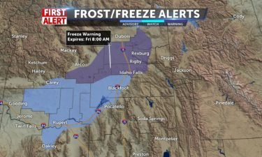
Freezing temperatures tonight, with lows back to the lower 30’s for Friday morning. The National Weather Service has issued a Freeze Warning for the…
Continue ReadingThe dust has settled overnight. Expect calm but cool weather, today. We’ll see another frosty morning Friday, but a warming trend will carry us back…
Continue Reading
Staying windy Wednesday evening and Thursday, as a cold front exits the region. We’ll look for sunny skies and a warming trend into the weekend. A…
Continue Reading
Gusty winds will be the main feature of a cold front, as it rolls through the area this afternoon. Gusts beyond 50 mph are expected to kick up dust,…
Continue Reading EASTERN IDAHO (KIFI/KIDK) A Wednesday afternoon cold front will drive in very gusty winds for our region. We’ll see a few thunderstorms, but the…
Continue Reading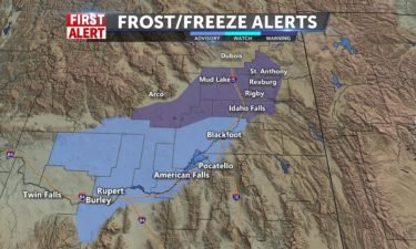
Clearing out from a weekend front, we are left with gusty winds, clearing skies and dropping temperatures overnight into Tuesday. Expect chilly…
Continue ReadingWeekend wind-storms have calmed down, and mild conditions have moved in for your Monday. Expect a dry forecast this week, with windy weather…
Continue Reading Breezy with some clouds to start Monday, temps still in the 60’s. We’ll hit the upper 60’s and low 70’s by Tue/Wed. A few more clouds with the…
Continue Reading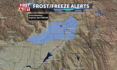
We’re seeing a few isolated showers Friday night after the cold front from Thursday. With cooler temperatures and clearing skies overnight, we expect…
Continue ReadingCalm weather is scheduled throughout the day Friday, but storms will return Saturday and Sunday. Expect on-and-off storm threats, with breezy…
Continue Reading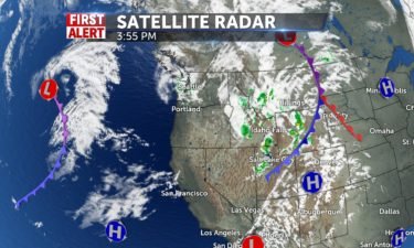
We’ll still see a few scattered thunderstorms late Thursday, with clearing and drying conditions for Friday. However, the jet stream continues to…
Continue Reading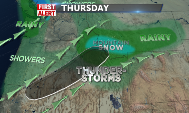
Thunderstorms will be a continued possibility throughout the day, with severe storms increasingly probable later in the day. A few isolated storms…
Continue Reading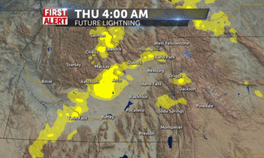
EASTERN IDAHO (KIFI/KIDK) A cold front moving through the region Thursday, will usher in a threat for showers and thunderstorms , with some cells…
Continue ReadingSunshine and Summer-like conditions can be expected all day, today. High temperatures into the 70’s and 80’s will beat seasonal averages by about 15…
Continue Reading
High pressure throughout the west will usher in a warm southwest flow for Wednesday, with highs around 80° for the local valleys. A front blows in…
Continue ReadingSunshine will dominate the weather forecast for Tuesday and Wednesday. Highs will hit average levels today, then leap well above average for…
Continue Reading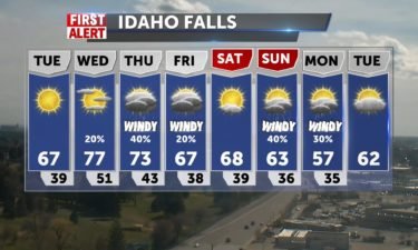
Gusty winds and clearing skies for Monday night and Tuesday as a frontal boundary clears to the east. We’ll see calmer winds for Tuesday with mostly…
Continue Reading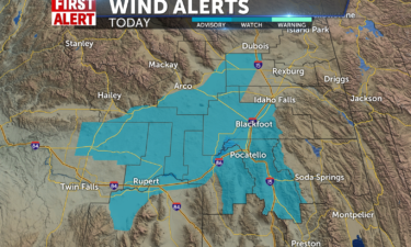
A wind advisory is in place for the Snake River Plain and Magic Valley today. Expect blowing dust as wind speeds reach beyond 30 mph. A few…
Continue Reading Wind Advisory through Monday night at 9pm. Gusty winds of 40-50mph are possible with blowing dust in the SRP, making for a hazy day. Highs around 70.…
Continue Reading A small chance of showers scattered over the region tonight with lows from mid 30’s to 50 in Pocatello. Clouds maintain with breezy conditions and…
Continue Reading
A few lingering showers for Friday evening, leftover from Thursday’s storm. We’ll see a few overnight showers with breezy winds.Warmer temperatures…
Continue ReadingSoutheast Idaho will enjoy much more sunshine today, with a few upper-elevation showers this evening. Temperatures will fall short of average today,…
Continue Reading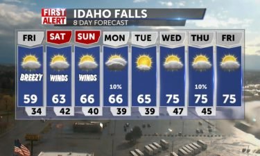
Very windy weather Thursday evening with the wind advisory expiring at 10PM . Even after 10PM, we’re still seeing gusty winds and a few scattered…
Continue ReadingActive weather will continue throughout the day, Today. Morning showers may even develop into thunderstorms by this afternoon. Wind speeds will also…
Continue Reading
A storm is approaching from the west for Wednesday night and Thursday. We’re going to see gusty winds, scattered snow/rain showers and cooler…
Continue ReadingSunshine will dominate the first part of the day, Wednesday. By this afternoon, cloud cover will increase and winds will pick up ahead of a cold…
Continue Reading
Nice tonight with lows falling back into the mid 30’s. Nothing showing up on VIPIR radar tonight. For tomorrow morning, we’ll see a nice start to the…
Continue ReadingTemperatures will climb back into the 60’s throughout the Snake River Plain, today. More active weather will hit the area in the form of a cold…
Continue Reading
High pressure with mostly sunny skies for Tuesday. A system moves in for Wednesday night with increasing cloud cover and scattered showers for…
Continue ReadingSunshine continues into the first part of the work-week. Temperatures will reach into the 60’s throughout the Snake River Plain,…
Continue Reading High pressure takes control of our weather for Monday and Tuesday. Highs rising to the 60’s and mid 60’s my Tuesday. Clouds roll in Wednesday before…
Continue Reading Lows tonight with partly cloudy and dry conditions around 26-40 from Jackson to Pocatello. Warmer than normal highs this week 60+ for most, and…
Continue Reading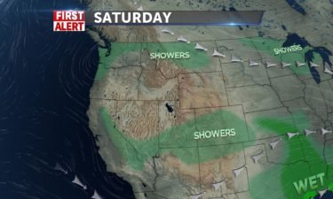
High pressure with us for Saturday with warmer temperatures. A weak storm system swings through with a few isolated showers for Sunday. Temps will…
Continue ReadingStorms have cleared the area, and we will enjoy mild conditions for the next several days. High temperatures will hit the mid-fifties today, but…
Continue Reading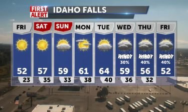
High pressure over the region for Friday and Saturday, with a warming trend into the weekend. Highs for Friday are looking to be warmer, but still…
Continue ReadingRain and snow storms are clearing, but wintry continues for today in the form of wind and cold. Highs will top out into the mid-forties, as wind…
Continue Reading
A vigorous cold front is moving through the region, with scattered showers and gusty winds through Wednesday night and into Thursday. Most of the…
Continue ReadingRain and snow showers will continue to affect the region throughout the day. The Snake River Plain will see wind speeds between 15 and 25…
Continue Reading
A cold storm system out of the north arrives Tuesday night and into Wednesday. Scattered snow/rain showers for Wednesday with gusty winds. We’ll see…
Continue ReadingCloud Cover will gradually increase, today, ahead of a more active Wednesday. Mountain snow and valley rain showers are expected by…
Continue Reading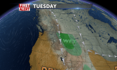
A cold system is moving in from the north, keeping us below average with our temperatures and breezy. We’ll also have a few snow and rain showers for…
Continue ReadingTemperatures will top out near 40 degrees, Monday, with clear skies and a mild breeze. Temperatures will warm toward Wednesday, when we can expect…
Continue Reading After a back-door cold front brought thundershowers and snow, skies clear for Sunday and temps will be in the 40’s. Colder air takes us into the…
Continue Reading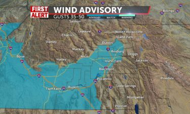
A cold front out of Montana is on the move for this weekend. A windy, stormy Saturday, as the cold front rolls in from the north. The…
Continue ReadingHigh temperatures will hit mid-sixties in the Snake River Plain, today. Watch for breezy winds today, between 5 and 15 mph. Stronger winds will set…
Continue Reading
We have a few showers in northern Utah, with Idaho staying dry with winds relaxing overnight into Friday morning. Friday, a trough of low pressure…
Continue ReadingTemperatures will top out into the upper 60’s today, with an anticipated high of 70 degrees for Pocatello. Expect clear and calm conditions. Wind…
Continue Reading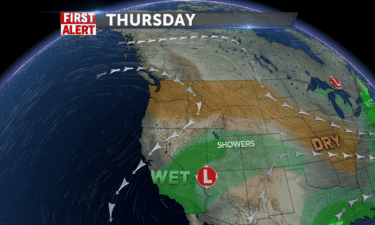
Mostly dry and breezy conditions for Thursday and Friday, with some high pressure over the Northwest. A cut-off low continues to spin through Nevada…
Continue ReadingTemperatures will top out near 60 degrees throughout the Snake River Plain, today. We will hold on to clear, sunny and calm weather through…
Continue Reading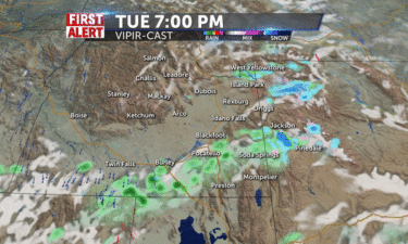
A Few thunderstorms Tuesday night with partly to mostly cloudy skies. Warmer weather with mostly sunny skies for Wednesday and…
Continue Reading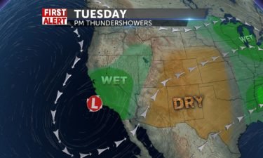
An area of low pressure is spinning of the California coast sending showers and thunderstorms late Monday and Tuesday. Look for some gusty winds as…
Continue ReadingOn and of rain showers will convert into scattered thunder-storm activity by Monday afternoon. Watch for the possibility of hail along with those…
Continue Reading Some unsettled weather into Sunday night and Monday, but sun for Tuesday and a mix with clouds for most of Easter Week, limited shower chances by the…
Continue Reading Rain/Snow chances on the jump up for the SRP and mountains into Sunday. Morning lows in the 20/30’s. Highs back into the mid 40/50’s. After a stormy…
Continue Reading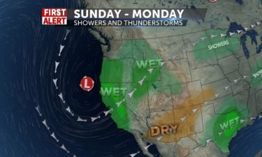
Sunny on Saturday with highs into the upper 40’s and lower 50’s with showers arriving into late Saturday night and early Sunday. This next round of…
Continue ReadingFriday will see more sunshine, with snow showers keeping to the higher elevations for now. Saturday is expected to be sunny, with warmer temperatures…
Continue Reading
Scattered snow showers late Thursday and Friday with some chilly temperatures for Friday. We’ll see temps into the 30’s and 40’s, with slightly…
Continue ReadingScattered snow showers will continue today, with storms losing steam through Friday. Expect a brief break from storm activity Saturday, with sunshine…
Continue Reading
A broad area of low pressure sits over the region with below average temperatures and scattered snow/rain showers. Another system swings in from the…
Continue ReadingTemperatures take a hit today, as active weather continues. Expect some light rain and snow activity this…
Continue Reading
Scattered showers and thunderstorms will push through overnight and into Wednesday, as our cold front moves off to the east. We’re stuck with a…
Continue ReadingThe Snake River Plane is under a wind advisory as a storm system passes through, today. Where rain is more sparse, watch for blowing dust as wind…
Continue Reading
We’re still on track to see a stormy Tuesday, thanks to a passing front and dropping area of low pressure from the north. Scattered showers and gusty…
Continue ReadingValley rain and mountain snow will pick up into the afternoon hours, Monday. High temperatures will reach 40’s and low 50’s for…
Continue Reading A cold front kicks off more showers and winds with a mix of snow and rain, especially Tuesday. Temps will drop significantly over the period, from…
Continue Reading
A rocky start to the week with a wet and windy flow from the northwest. Look for scattered showers Sunday, Monday and Tuesday as a cold front…
Continue ReadingClear skies will give way to cloud cover over the course of the day, Friday. Mountain showers are possible Friday and Saturday, with more widespread…
Continue ReadingStorms have cleared, but temperatures will just be reaching into the low-40’s Thursday and Friday. Partially cloudy skies will carry us into the…
Continue Reading Scattered snow showers will convert to rain by this afternoon for the Snake River Plain. Active weather with breezy winds will continue for today,…
Continue ReadingWind speeds will trend toward 20 mph throughout the day Tuesday, with some gusts pushing toward 30 mph. Expect scattered rain showers this afternoon…
Continue Reading 40% Chance of snow/rain for IF & 70% Chance in Pocatello with brisk winds from the SW with a trough pushing through by Wednesday. SE Idaho…
Continue ReadingA cold front will move into the area by early afternoon today. Expect valley rain and mountain snow, with cooling temperatures into the next few…
Continue Reading SE Idaho has a better chance of showers and we’ll some sun in Pocatello Sunday. 30% shot of rain/snow and cloudy into the morning, then some clearing…
Continue Reading SE Idaho has a better chance of showers tonight and we’ll some sun in Pocatello tomorrow. 30% shot of rain/snow tonight and cloudy into the morning,…
Continue Reading A few scattered showers for Friday night and Saturday as we continue to see an area of low pressure slowly moving to our south. A large storm system…
Continue ReadingA storm system to our South will continue to push cloud cover and some active weather into the region. Expect rain and snow in the mountains, with…
Continue Reading An upper level low will sit to our southeast with another area of low pressure sliding in behind. This will deliver a slight risk of rain and snow…
Continue ReadingExpect mostly cloudy skies today, with temperatures reaching into the mid to upper 40’s this afternoon. Skies will become more clear by the weekend…
Continue Reading A few scattered rain and snow showers for our region Wednesday night and early Thursday as our area of low pressure slowly dies off. A drier weather…
Continue ReadingValley rain and mountain snow will continue today and tomorrow. Expect more sunny conditions by the…
Continue Reading Keeping unsettled conditions with a scattered shower and thunderstorm possible for Wednesday and Thursday. Highs near normal with temps into the 40’s…
Continue Reading
A slow moving area of low pressure to our south is sending scattered showers and thunderstorms in our direction. Nicer weather gets back in here for…
Continue ReadingLight lingering showers will continue through the week after a more active weekend. Expect relatively warm temperatures with highs rising into the…
Continue Reading We’ll see more passing showers tonight, rain, then snow, with some thunder, temps around freezing in the plain and 21 in Jackson and Salmon tonight.…
Continue Reading