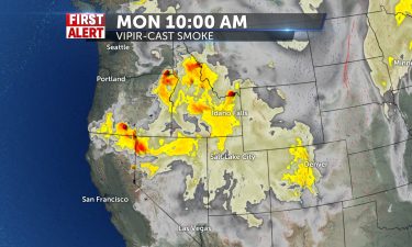
Hazy Conditions to Continue into the Work Week
Smoky conditions have made their way into Eastern Idaho and Western Wyoming…
Continue Reading Smoky conditions have made their way into Eastern Idaho and Western Wyoming…
Continue Reading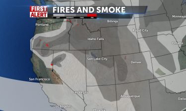
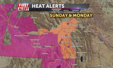
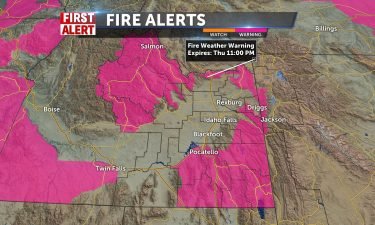
RED FLAG WARNING IN EFFECT FROM NOON TODAY TO 9 PM MDT THIS
EVENING FOR GUSTY WINDS AND LOW RELATIVE HUMIDITY for Fire Weather Zone 410 Upper Snake…
FIRE WEATHER WATCH IN EFFECT FROM SUNDAY AFTERNOON THROUGH
SUNDAY EVENING FOR GUSTY WINDS AND LOW RELATIVE HUMIDITY for Fire Weather Zone 410 Upper…
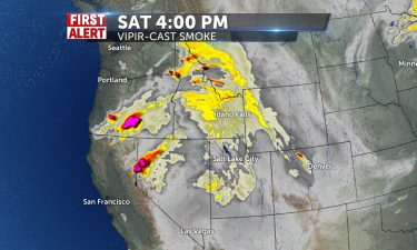
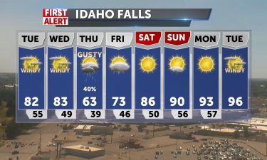
Winds will relax into Saturday, with highs well into the 90’s. More smoke will drift in from fires burning in north Idaho, Montana and Oregon. Highs…
Continue Reading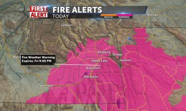
TODAY: There should be mostly sunny skies with no rain chances for much of the area. A slight sprinkle might occur possibly in Yellowstone and the…
Continue Reading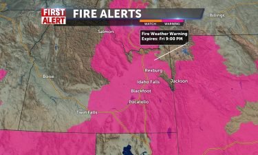
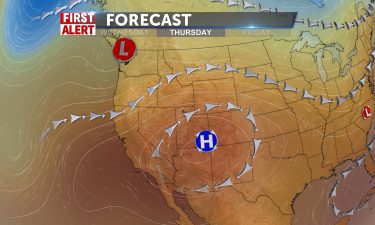
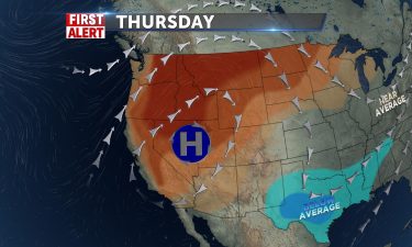
High pressure to our south, low pressure to our north, leading to hot and breezy conditions locally. The National Weather Service has issued Red Flag…
Continue Reading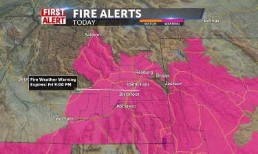
RED FLAG WARNING IN EFFECT FROM NOON TO 9 PM MDT TODAY FOR
GUSTY WINDS AND LOW RELATIVE HUMIDITY FOR FIRE WEATHER ZONES 410 Upper Snake River…
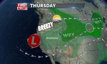
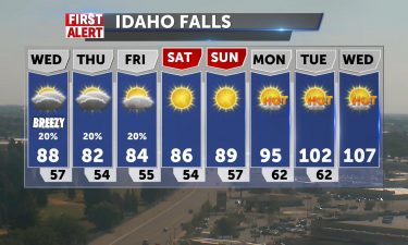
Scattered thunderstorms, tonight with some gusty winds. Lows will be around 60°. THURSDAY: Hot and mostly sunny with highs into the mid 90’s. Gusty…
Continue Reading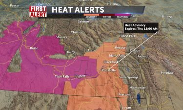
High pressure over the western states continues to pump in the heat from the south. We’ll see temperature highs well into the 90’s, with some spots…
Continue Reading
People around Bridger-Teton National Forest, Grand Teton National Park, and National Elk Refuge are hearing Harrison Ford’s message about growing…
Continue Reading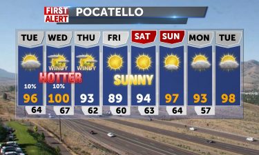
Fire Weather Watch for much of our area, with chances of PM storms/lightning, especially Wednesday, with 40-50mph winds with storms possible. Also,…
Continue Reading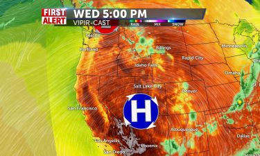
Scattered thunderstorms this evening and tonight. Clearing skies with lows into the mid 50’s. Sunny skies for Tuesday with highs into the lower to…
Continue Reading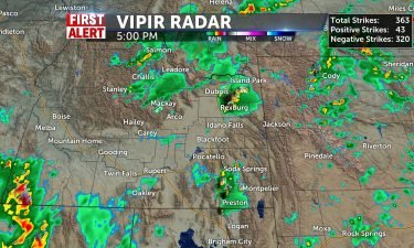
TONIGHT: We currently have some showers and thunderstorms in the area. Rain showers are lining up in the Central Idaho Mountains and two good sized,…
Continue Reading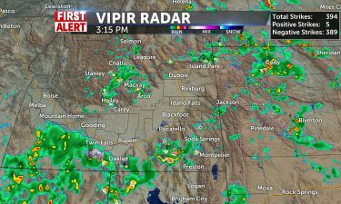
AFTERNOON/TONIGHT: Currently, we have lots of isolated thunderstorms across various parts of the region. There is a line of showers currently…
Continue Reading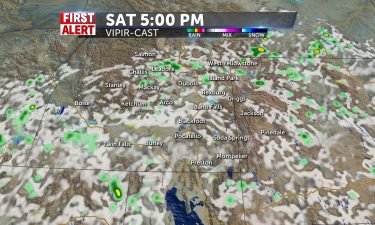
Hot temps well into the 90’s for the Snake River Plain, with some monsoonal moisture sticking around, delivering a few thunderstorms. Saturday,…
Continue Reading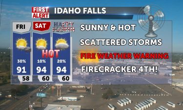
Still hot and unsettled in the afternoon from lunch to late night with a chance of isolated thunderstorms for us today, mainly in mountain regions,…
Continue Reading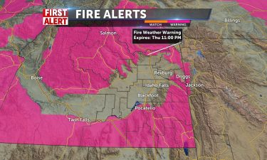
We’re still looking at hot temps well into the 90’s this week and weekend. An area of low pressure over Utah, will drag in some monsoonal moisture…
Continue Reading
Overnight: Lows around 60°, with a slight chance of thunderstorms. Thursday: Highs into the lower 90’s, with isolated showers and thunderstorms…
Continue Reading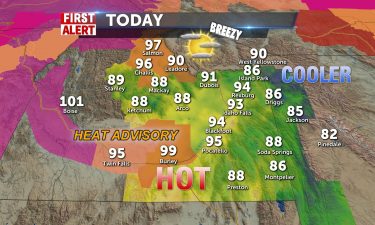
Our hot days continue with a reprieve of heat advisories, but remaining toasty in the 90’s for most of us. Mid 80’s into mountain areas/Tetons,…
Continue Reading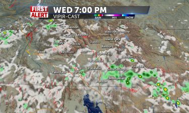
Highs are expected to be well into the 90’s with a slight risk of afternoon and evening thunderstorms. Overnight: Mostly clear with lows into the…
Continue Reading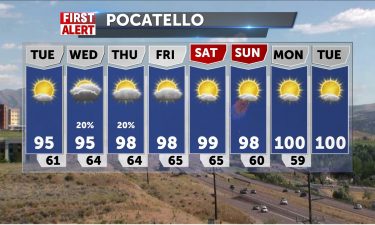
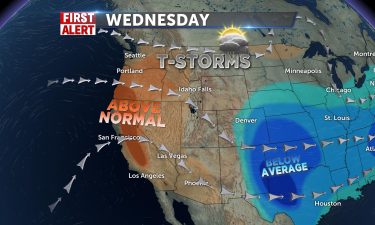
A strong ridge of high pressure will deliver above average highs well into the 90’s this week. The position of the ridge of high pressure along with…
Continue Reading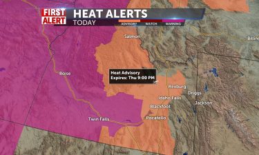
Surging high pressure and a diving jet stream will make for a dome of heat over Washington and Oregon and western Idaho. Heat advisory for our area…
Continue Reading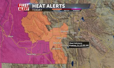
TONIGHT: Mostly Clear skies are expected throughout the night tonight with no rain chances. Winds are expected to be light from 5-15 mph throughout…
Continue Reading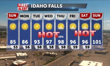
TONIGHT: We can expect mostly clear skies throughout tonight with good breezes from the north ranging from 5-20 mph throughout the region. Some gusts…
Continue Reading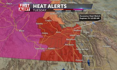
Tonight, chance of thunderstorms with lows into the lower 50’s. Gutsy winds thanks to the passing thunderstorms. Saturday, look for mostly sunny…
Continue Reading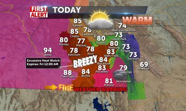
Before the expected heatwave next week, we expect clouds to scattered with a chance of a storm this afternoon and temperatures only in the lower 80’s…
Continue Reading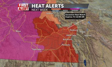
For our Thursday evening, look for scattered thunderstorms and gusty winds. High pressure building over the region this weekend and next week, will…
Continue Reading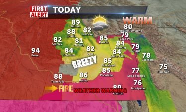
Gusty winds for Wednesday night with scattered thunderstorms. Winds 10-25 MPH, with lows into the upper 50’s. Some of these storms will carry over…
Continue Reading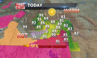
Our southwest flow is still in place with highs well above average into the upper 80’s and lower 90’s. We’ll also increase the risk of thunderstorms…
Continue Reading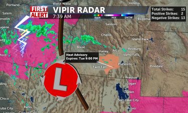
A few storms across the state from a trough pushing through into tonight and Wednesday. Our temps from 92-97 in the valley today will cool to the…
Continue Reading
High pressure to our south slowly moving east and a low pressure off the California coast, will send heat in our direction. Overnight into Tuesday…
Continue Reading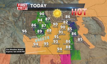
Sunny for the first full day…
Continue Reading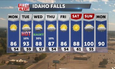
TONIGHT: More Northerly winds are expected, but only between 5-15 mph. These winds should cool down the low temperatures back to the high 40’s in the…
Continue Reading
TONIGHT: There is a red flag warning in effect for much of eastern Idaho until 10pm tonight. Low humidity levels, high winds gusting up to 40 mph,…
Continue Reading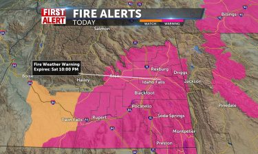
OVERNIGHT: Conditions should be fairly calm throughout the night. Temperatures get down to the 50’s throughout much of the area with only a slight…
Continue Reading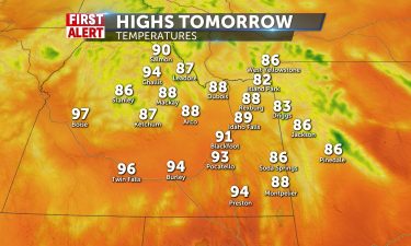
TONIGHT: Cloud cover will continue to be slim into the night tonight as we should expect mostly clear skies with no rain chances. Winds should be…
Continue Reading
Continued warm and getting warmer into the kickoff of the weekend. Highs today under sunshine – upper 80’s to low 90’s from Idaho Falls to Pocatello.…
Continue Reading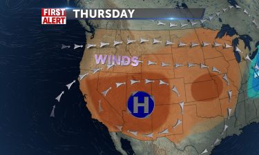
Temperatures will continue to rise for Thursday, Friday and Saturday, thanks to high pressure to the south over the Four Corners. There will be a few…
Continue Reading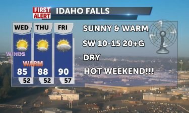
High Pressure maintains the dry, sunny conditions with winds pushing from SW/W over the next couple of days 10-15 mph, gusting to 20-30.…
Continue Reading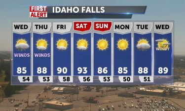
We’ll see breezy conditions with slightly cooler temperatures for Wednesday. We’re going to flatten out the ridge of high pressure, taking our highs…
Continue Reading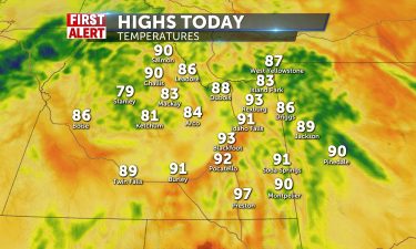
TODAY: Fires are currently burning just to the west of Pocatello and south of American Falls. Fire weather might ramp up today as…
Continue Reading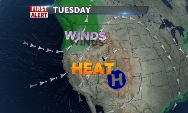
High pressure to the south sending heat, low pressure to the northwest sending some wind. OVERNIGHT: Mostly clear with a low around 60°, winds 10-20…
Continue Reading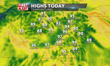
TODAY: High temperatures could reach record highs again for today as most of the valley’s are looking at temperatures in the mid 90’s and mountainous…
Continue Reading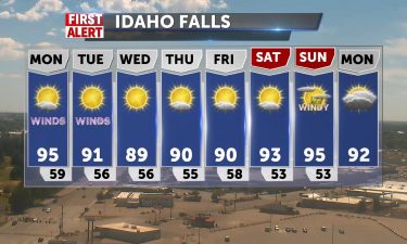
Temperatures above average for the start of the workweek, with highs well into the mid to upper 90’s for Monday afternoon. A Pacific northwest trough…
Continue Reading
OVERNIGHT: Temperatures should cool down a bit for the night down to the high 40’s for most of the region after getting the highs to the lower to mid…
Continue Reading
Staying a bit breezy Friday night into this weekend, with some cloud cover entering Central Idaho communities. There’s a slight chance of some…
Continue Reading
TODAY: We are beginning to warm up after the cold front that came through yesterday. High temperatures are expected to be in the mid 60’s in the…
Continue Reading
We’ll lose our windy weather and showers by late Thursday night. Winds will slow a bit into Friday, with a chilly start to the morning. The National…
Continue Reading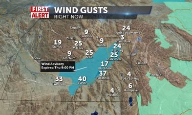
Gusty southwesterly winds from a solid cold front through the morning will create some blustery conditions today, with 15-30 mph wind. Gusts could…
Continue Reading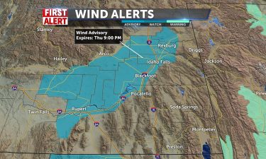
OVERNIGHT: Gusty winds, Partly cloudy, with a low into the lower 50’s. South wind 15 to 20 MPH, with gusts as high as 30 MPH. An area of low pressure…
Continue Reading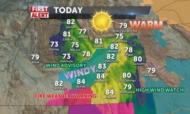
Sunny, Warm, Windy today and low-to-mid 80’s for most of us in the valley and Salmon/Jackson. Mountain villages pop into the mid 70’s and winds will…
Continue Reading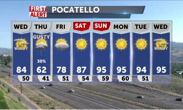
Tuesday evening, look for a chance of thunderstorms with lows around 60°, with winds around 15 MPH. We’re losing our ridge of high pressure to an…
Continue Reading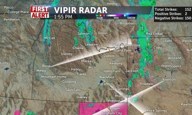
A slow moving area of low pressure in the Northwest, will keep us warm and breezy. That area of low pressure, will get overhead by Thursday. Tuesday:…
Continue Reading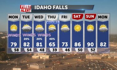
We gather some temperature momentum before another significant change for the region by late Wednesday and Thursday as cooler air and storm chances…
Continue Reading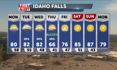
OVERNIGHT: The wind is expected to die down as we head into the night with winds sticking between 5-15 mph. Temperatures should be similar to last…
Continue Reading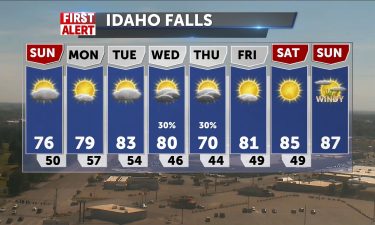
OVERNIGHT: We have a wind advisory in effect just east of Idaho Falls until 9pm tonight. Most places are currently seeing sustained winds of 20-30…
Continue Reading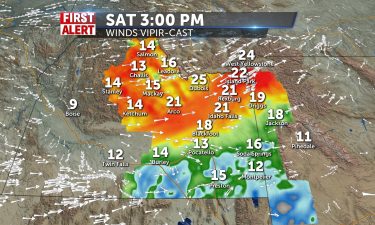
We’re seeing our strong ridge of high pressure, retreat to the south. This will open the door for some slightly cooler temps to push in for this…
Continue Reading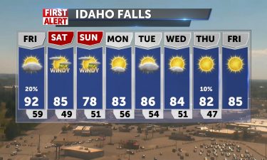
Hot temperatures with a slight chance of thunderstorms for Friday afternoon. We’ll see highs well into the 90’s for the valleys and the Snake River…
Continue Reading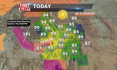
A strong ridge of high pressure is settling in overhead. Highs for Thursday and Friday are expected to reach into the lower 90’s. Tonight, mild lows…
Continue Reading
Strong high pressure means hot dry weather for us for the rest of the work week. Stay cool in the upper 80’s today, closer to 90-91 in…
Continue Reading
High pressure over the west, will continue to deliver above average temperatures locally, with highs around 90°. We’ll have a slight chance of…
Continue Reading
Temps keep rising this week, thanks for high pressure. Very dry conditions and light winds and non-stop sun will hike afternoons from the low 80’s…
Continue Reading
An upper level ridge of high pressure continues to spin in from the west. Look for increasing highs into the 80’s and 90’s, with a minor theat of…
Continue Reading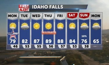
Beautiful start to the week with clear morning conditions, light variable winds and a slight morning chill, however we’ll warm up nicely today. High…
Continue Reading
OVERNIGHT: We should have mostly clear to partly cloudy skies throughout the region tonight with no rain chances at all expected. Temperatures should…
Continue Reading OVERNIGHT: We should expect to see fairly calm conditions with being mostly clear toward the north and mostly cloudy toward the south of the region.…
Continue Reading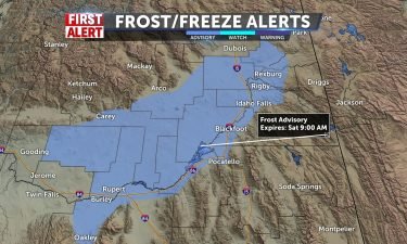
We’ll look for an exiting system to drop in cold overnight lows for Saturday morning. However, warmer temps are on the way with a building ridge of…
Continue Reading WIND ADVISORY REMAINS IN EFFECT UNTIL 9 PM MDT THIS EVENING……FROST ADVISORY IN EFFECT FROM 4 AM TO 9 AM MDT SATURDAY… WHAT…For the Frost…
Continue Reading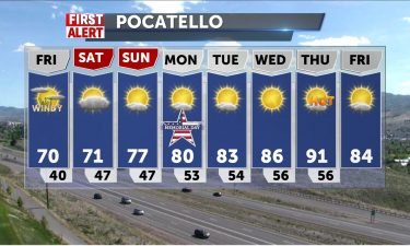
An area of low pressure with a cold front will move through the region for Friday. We’ll see just a few thunderstorms possible near Yellowstone NP,…
Continue Reading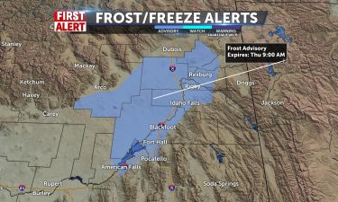
We have an area of low pressure overhead, moving to the east. Most of the shower activity, will move Montana and eastern Wyoming late Wednesday into…
Continue Reading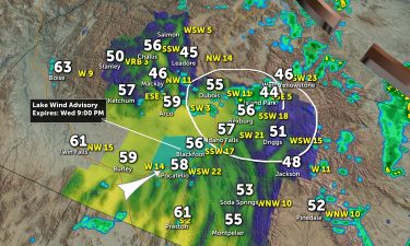
Scattered shower/storm chances linger this afternoon with gusty winds. Highlands see better risk of isolated storms, but chances remain for the rest…
Continue Reading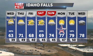
An area of low pressure is working through the region, with cooler highs for Wednesday, along with scattered showers and gusty winds. OVERNIGHT:…
Continue Reading
More clouds into the day with shower/storm chances to 50% by later. Clouds will probably prohibit the lunar eclipse of the blood flower moon…
Continue Reading An area of low pressure is moving in from the northwest for Tuesday and Wednesday. Look for a chance of thunderstorms, showers and gusty winds for…
Continue Reading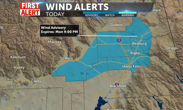
Scattered showers and thunderstorms for Monday afternoon with a wind advisory issued by the National Weather Service. WIND ADVISORY IN EFFECT FROM…
Continue Reading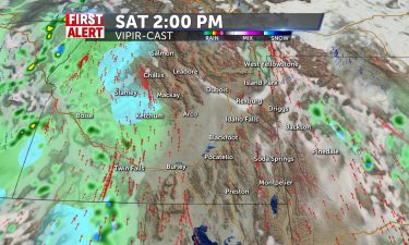
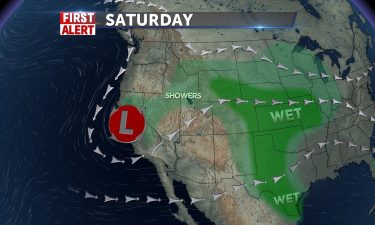
An area of low pressure to our south, remains in the forecast for this weekend. Things are a little drier for Saturday, with just a few showers in…
Continue Reading
Southerly Flow continues from Lake Tahoe with showers in most viewing communities this morning. Snow in mountains likely and storms likely 70%…
Continue Reading
An area of low pressure is slowly moving south, dropping in cooler temps and scattered showers for Friday and this weekend. OVERNIGHT: A chance of…
Continue Reading
Unsettled conditions bring increased winds SW 15-20/30mph gusts with mainly mountain storm chances today and highs only in the mid 60’s. 60% chance…
Continue Reading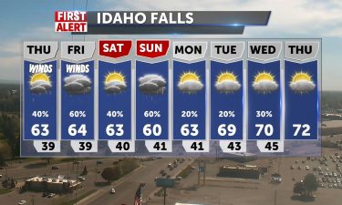
An area of low pressure is moving through the northwest heading south. This will drop our highs back into the 60’s with scattered thunderstorms and…
Continue Reading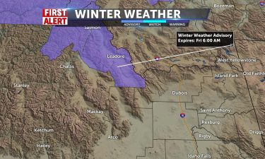
Southwestern flow, a meandering low, and cold front approaching will all contribute to showers and storms mainly for the eastern Idaho/western…
Continue Reading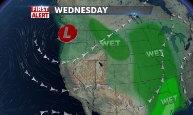
An area of low pressure is moving in from the northwest, we’ll increase the threat for thunderstorms and see cooler temperatures for Thursday and…
Continue Reading
A dry cold front will drive winds up today and a warm SW flow will take us into the mid-to-upper 70’s for most. 78 in Dubois , 77 Rexburg, and 74 in…
Continue Reading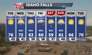
We’re keeping a warm southwest flow ahead of a Pacific northwest low. Above average highs for Tuesday, with gusty winds in the afternoon. OVERNIGHT:…
Continue Reading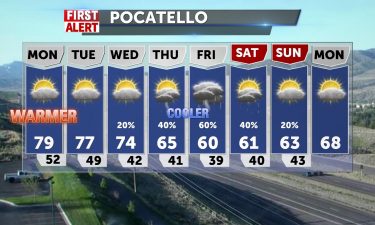
An area of low pressure along the coast, is ushering an southwest flow and some instability. We’ll see a chance of thunderstorms Friday night,…
Continue Reading
Some scattered thunderstorms Thursday night, along with gusty winds. Overnight lows into the mid 40’s. Highs for Friday will get into the mid to…
Continue Reading
Breezy into Thursday afternoon W 10-20+ with a cold front and scattered shower chances are light. Warm, 75-79, upper 60’s for Jackson. Mild…
Continue Reading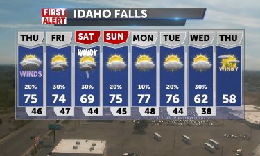
High pressure over the west will deliver warmer than average temperatures. Highs for Thursday and Friday will reach into the mid to upper 70’s for…
Continue Reading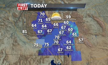
We’ll see 70 around today with breezes from the SW 10-15/G20, Idaho Falls around 67 and 61 in Jackson. We’re trending to even warmer conditions…
Continue Reading
High pressure continues to build in throughout the west. With lows into the 30’s, the National Weather Service has issued a frost Advisory for…
Continue Reading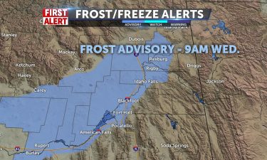
Some showers/storms possible for eastern I-15 into Wyoming for the afternoon with leftover moisture and heating of the day kicking up the activity.…
Continue Reading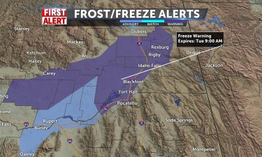
An upper level low over the region will keep cool temps in place for Monday night and a risk of showers and thunderstorms. The National Weather…
Continue Reading
Frost Advisory through 9am for Snake River Plain, and chilly air in place with rotating moisture from the east gives mainly mountain showers, some…
Continue Reading