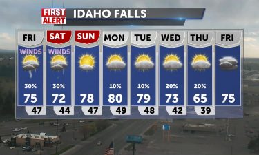
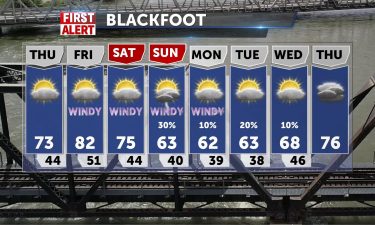
Warm temps for Friday with thunderstorm risk
Some scattered thunderstorms Thursday night, along with gusty winds. Overnight lows into the mid 40’s. Highs for Friday will get into the mid to…
Continue Reading Some scattered thunderstorms Thursday night, along with gusty winds. Overnight lows into the mid 40’s. Highs for Friday will get into the mid to…
Continue Reading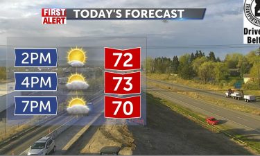
Breezy into Thursday afternoon W 10-20+ with a cold front and scattered shower chances are light. Warm, 75-79, upper 60’s for Jackson. Mild…
Continue Reading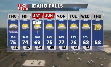
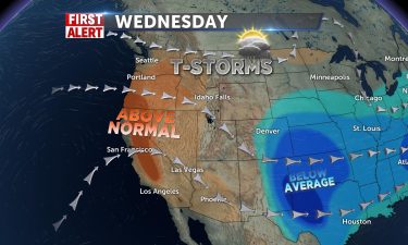
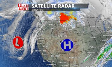
High pressure over the west will deliver warmer than average temperatures. Highs for Thursday and Friday will reach into the mid to upper 70’s for…
Continue Reading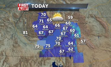
We’ll see 70 around today with breezes from the SW 10-15/G20, Idaho Falls around 67 and 61 in Jackson. We’re trending to even warmer conditions…
Continue Reading
High pressure continues to build in throughout the west. With lows into the 30’s, the National Weather Service has issued a frost Advisory for…
Continue Reading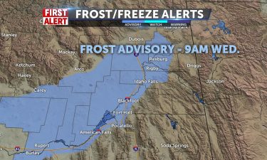
Some showers/storms possible for eastern I-15 into Wyoming for the afternoon with leftover moisture and heating of the day kicking up the activity.…
Continue Reading
An upper level low over the region will keep cool temps in place for Monday night and a risk of showers and thunderstorms. The National Weather…
Continue Reading
Frost Advisory through 9am for Snake River Plain, and chilly air in place with rotating moisture from the east gives mainly mountain showers, some…
Continue Reading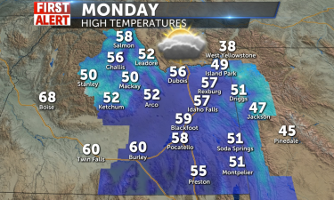
Cool for Sunday with highs into the mid 50’s. An area of low pressure is keeping us cooler than average with some showers working into the region…
Continue Reading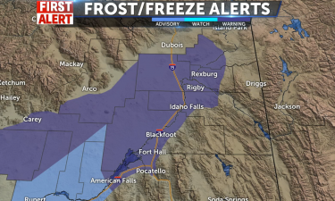
Idaho Falls (KIFI) – With cold air in place from the Friday cold front, we’ll see freezing temperatures early Sunday morning. The National Weather…
Continue Reading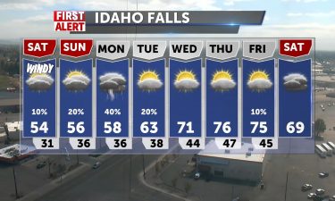
A cold front moving out the region will drop in colder temps for this weekend with gusty winds for Saturday. We’ll also see a risk for some showers…
Continue Reading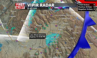
Big difference from yesterday’s near 80 degree temps, with highs in the low 70’s today. Partly sunny with a sligh chance of storms in the Snake…
Continue Reading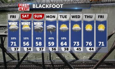
With a cold front moving through the region Thursday evening, look for gusty winds and a few showers. We’ll see dropping temperatures into the…
Continue Reading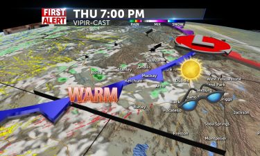
Changes coming later today, but first. highs in the 79-80’s, low 70’s for mountains and even 90 in Boise. Cold front will drive winds and colder air…
Continue Reading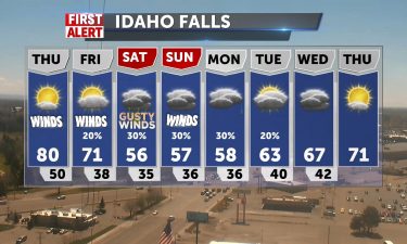
A cold front is approaching from the west. As this front nears, look for warm winds out of the southwest, driving in highs into the lower 80’s. The…
Continue Reading
High pressure continues to create nice weather for a couple of days in East Idaho. A system will show up late tomorrow and forecast changes to cooler…
Continue Reading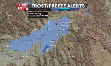
An area of low pressure in Montana and associated cold front is driving in a few showers and thunderstorms for Tuesday evening. We’ll see cold…
Continue Reading
Winds will be SW 10-20mph with gusts to near 30 and a Lake Wind Advisory along I-15 corridor to American Falls Reservoir through 9pm. Partly sunny…
Continue Reading
Another cold front is moving through the region for Tuesday, with just a few showers possible, along with gusty winds. Looking nicer for Wednesday,…
Continue Reading
A few disturbances will interrupt the warm, record-breaking, temperatures we experienced on Friday. We set records today, but this streak will end…
Continue Reading
We’ll continue to warm-up as we move into Thursday and Friday with strengthening high pressure over the west. Winds will begin to increase for…
Continue Reading
High pressure over the west will deliver sunny and warmer conditions around the region. We’ll have a slight chance of showers in Yellowstone NP and…
Continue Reading
High pressure will help relieve the gloomy weather we’ve had for the past few days. Clearing out with light breezes today, clouds this morning and…
Continue Reading
An area of low pressure over the west is deepening. We’ll see a few isolated showers for Tuesday, with some cloud cover and afternoon winds around 15…
Continue Reading
A Pacific system makes for a nasty day in East Idaho and Western Wyoming. Highs from mid 40’s in Jackson to low 50’s in Pocatello and 58 in…
Continue Reading
A cold front exiting Montana will deliver a few isolated thunderstorms and gusty winds Friday evening. We’ll begin to see a bit of a break in the…
Continue Reading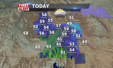
Partly Sunny today with increasing clouds with a low pressure system that settles into tomorrow bringing winds from the WSW 10-20+ mph and chances…
Continue Reading
A cold front moving through Montana will deliver a few isolated showers Thursday night and gusty winds Friday afternoon. A deeper system takes aim…
Continue Reading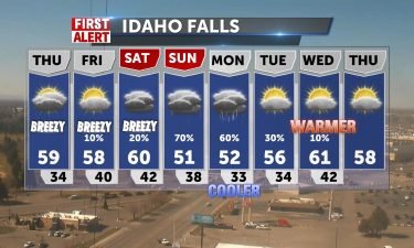
Increasing cloudiness before chances of showers into the night from 50-61 today in the valley to chilly 30’s tonight and some mtn showers into Friday…
Continue Reading
We’ll see a cold front sliding through Montana over the next couple of days. Then, a Pacific storm system moves in for this weekend. Overnight:…
Continue Reading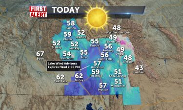
We continue to enjoy dry conditions and sunshine for today before cloudiness and a chance of showers late Thursday. Highs will edge toward 60…56-59…
Continue Reading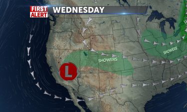
We’re looking at a dry patch of air with warming temps for Wednesday, as an area of low pressure moves through Utah. Overnight lows will drop into…
Continue Reading
Several sunny and dry days headed our way with highs headed to 60 by mid-week. Winds NNE 10-15 gusting to 20mph today with highs in the upper 40’s to…
Continue Reading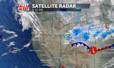
An exiting cold front will leave us cooler for Tuesday with some leftover winds. Overnight: Lows into the mid 20’s for the Snake River Plain, with…
Continue Reading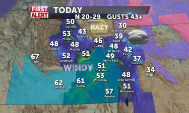
A backdoor cold front strikes today with winds from the north 20-30 mph, gusting to 45 today. A slight chance of showers this morning may being some…
Continue Reading

High pressure working into the northwest will deliver sunny skies and warmer temperatures. Our next storm chance arrives Monday out of Montana.…
Continue Reading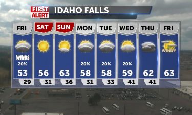
We’ll still have a few leftover showers for Thursday evening into Friday, with partly to mostly cloudy skies. Lows back to the upper 20’s to the…
Continue Reading
A storm is passing through northern Utah, with scattered rain/snow showers moving in from the southeast. Overnight: Chance of snow and rain showers…
Continue Reading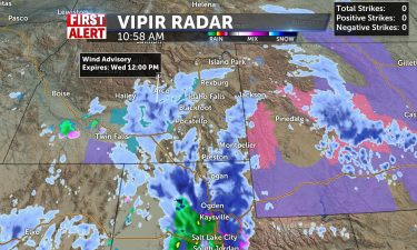
Blustery conditions into tonight with cold winds and scattered snow/rain. Highs will barely make it past 50 degrees and tonight with be dreary as…
Continue Reading
An area of low pressure is moving through northern Nevada and Utah for Wednesday. Look for scattered rain and snow showers over the next couple of…
Continue Reading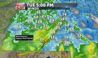
Wind Advisories are in effect for many counties in the valley and American Falls Reservoir and Bear River Range and Cache Valley in Utah are under a…
Continue Reading
An area of low pressure will develop over Oregon and and the Great Basin. For Tuesday, look for highs into the 50’s with gusty winds. The National…
Continue Reading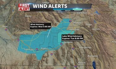
Mainly sunny today with winds from NNE from 10-15 mph and gusting to 22. Clear and cold tonight, with lows just below freezing. I’m forecasting a…
Continue Reading
After the cold front exits for Sunday, we’ll see calmer winds and cooler temps for Sunday. Our next storm arrives late Tuesday. Sunday: Sunny, with a…
Continue Reading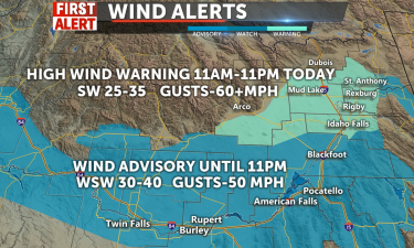
A strong front will push through the region Saturday. With this front, we’ll see a few isolated snow and rain showers. However, the main concern with…
Continue Reading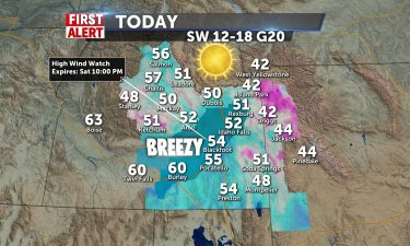
After a rough afternoon, dusty winds at 68 mph in Idaho Falls, yesterday, we will have a sunny, pleasant day today. Highs 52-54 and 40 in Jackson…
Continue Reading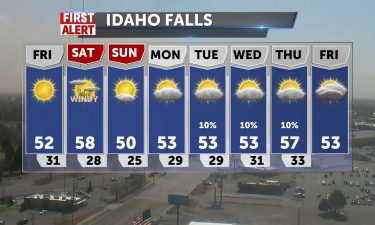
Gusty winds will continue into tonight, with lighter winds expected for Friday. Overnight lows will drop back below freezing with temperatures into…
Continue Reading
Wind Advisory through 10pm tonight for the viewing area. Gusty winds 25-35 and gusting to 50mph or more expected into the afternoon. Highs in the mid…
Continue Reading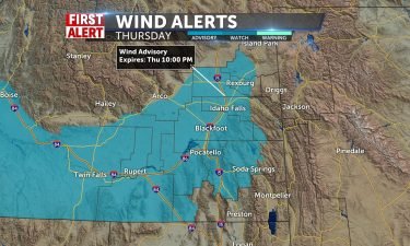
A cold front from the northwest will usher in gusty winds throughout the region. The National Weather Service has issued a wind advisory for…
Continue Reading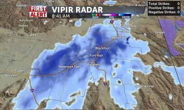
1-3″ is possible through the morning as this wrap around system churns snow & rain mixing through the mid-morning. Everything should drift south…
Continue Reading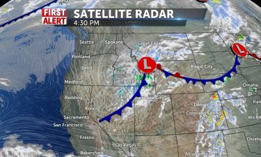
An area of low pressure and an associated cold front is moving through the region. We’re keeping gusty winds in the forecast with dropping…
Continue Reading
Mostly cloudy with a front crossing the area, kicking up winds SSW 15-30 mpg gusts. Patchy blowing dust and showers/thunderstorms by mid afternoon in…
Continue Reading A potent system is on the move for Monday afternoon and evening. We’ll see scattered showers and thunderstorms, with that moisture turning over to…
Continue Reading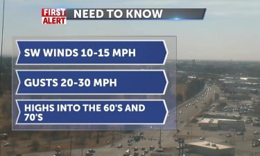
Warm and windy conditions with high pressure to our south and a cold front to our north. This combination will give us highs into the 70’s for…
Continue Reading
High pressure with winds from the south 10-15 gusting to 20mph this afternoon make our weather beautiful through the Easter weekend. Highs hit record…
Continue Reading
High pressure over the Four Corners is delivering warmer temperatures, along with winds from the south. Upper level winds from the south are being…
Continue Reading High pressure with winds from the south 10-15 gusting to 20mph this afternoon make our weather beautiful through the Easter weekend. Highs hit the…
Continue Reading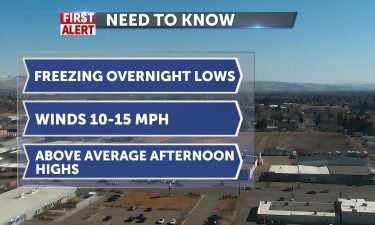
We’ll begin to see increasing winds out of the southwest by Thursday afternoon. With those winds, we’ll see highs into the 60’s. Overnight: Clear…
Continue Reading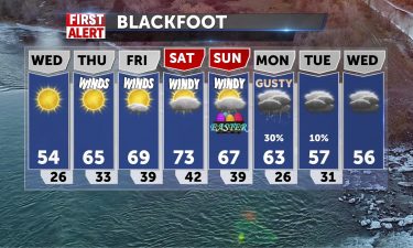
Breezy tonight with a few scattered snow showers in our local mountains. We see a warming trend through the rest of the workweek with highs into the…
Continue Reading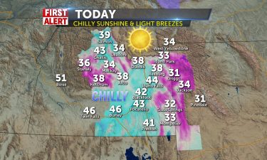
High pressure has pushed out all the clouds and precipitation, and the winds from yesterday ushered in cool air, keeping temperatures today in the…
Continue Reading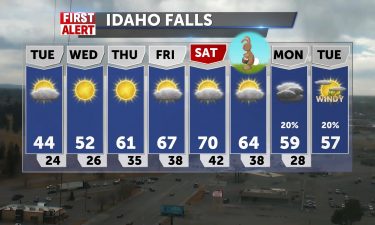
Our winds are slowly backing down to lighter levels for Tuesday, with our exiting cold front. We’ll see cold temperatures with a freezing Tuesday…
Continue Reading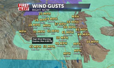
A strong cold front with some precip, but mainly heavy winds affects our weather today. High Winds we warned you about will gust beyond 60…
Continue Reading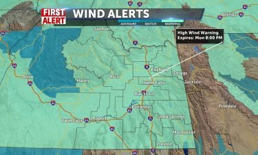
A strong cold front is moving through the Pacific Northwest, Sunday evening into Monday. This front, is expected to bring in scattered snow and rain…
Continue Reading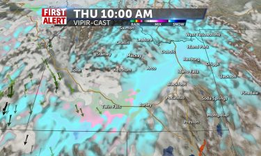
We’ll see some snow mixed with rain blowing around through the day, with highs in low to mid 40’s. Accumulations in mountain areas of a couple of…
Continue Reading
Grab your overcoat! Snow develops overnight with slight accumulations for the valley and 2-4″ for Rexburg, 4-8″ for Island Park, and several inches…
Continue Reading
High pressure has made for a cold and bright start, then clouds increase with highs in the low to mid 40’s, 35 in Jackson. Snow develops for central…
Continue Reading
Clearing tonight and cold arctic air settle in tonight and winds still gusting 20+ from the north will clear most showers out. You can expect a clear…
Continue Reading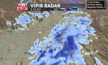
Rain/snow continue to push to the NE with SW winds up to 20+mph this afternoon and into tonight. We’ll have more showers through the night and…
Continue Reading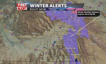
A Pacific low from the northwest is sliding through the region this weekend. We’ll see snow and rain showers, along with gusty winds. A second cold…
Continue Reading
Winds are increasing overnight into Friday, with an approaching storm. This storm is ushering in a cold front on Friday with gusty winds, rain and…
Continue Reading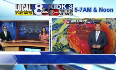
Enjoy the mild temperatures and sun today, around 55-58 for the plain. Still mild tomorrow, but winds kick in S-20+ and rain/snow mix drops in from…
Continue Reading
High pressure and a SW flow, delivering some nice, above average weather. However, a cold front is on the way for Friday. This cold front will usher…
Continue Reading
High pressure makes for a mild couple of days in the 50’s to 60 degrees for the Plain. Sunny to partly sunny before snow plows into the central…
Continue Reading
We’re seeing just a few isolated showers this evening around the mountains of far eastern Idaho and Western Wyoming. High pressure is working in from…
Continue Reading
High pressure brings us sun with light breezes from the north 5-10mph. Don’t rule out a scattered shower in the mountain communities as the last…
Continue Reading
A low pressure system is moving to our south, which will send in a few isolated showers for Tuesday. Most of the showers will favor the mountains and…
Continue Reading
That approaching pacific storm system will split and we’ll only see a limited chance of showers for mountain communities today with a partly sunny…
Continue Reading
A low pressure system is moving through the four corners region with showers to our south and warmer air getting pumped into our region. We’ll see a…
Continue Reading
We have an area of low pressure to our south over Utah, spinning up scattered snow showers to our south. We’ll have a few snow showers possible for…
Continue Reading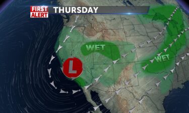
An area of low pressure is continuing to slide into Southern California and Arizona over the next couple of days. We’ll keep mainly dry conditions in…
Continue Reading
A low pressure system is slowly making its way down the Pacific coast. Off of that low, we’re seeing some clouds and a few isolated showers in our…
Continue Reading
A disturbance from a Pacific low pressure center, is slowly working across the region this evening. We’re seeing a few snow and rain showers, mostly…
Continue Reading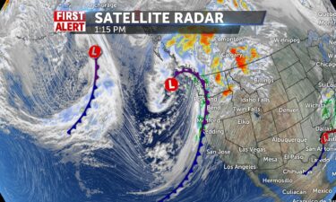
Expect to see a change-up in our weather pattern with a series of systems moving through. The first system moves through for Saturday with gusty…
Continue Reading
We should see some sun today with chilly temperatures in the 40’s for the Snake River Plain and 50+ Pocatello and Salmon. Weak front late in the…
Continue Reading
Partly cloudy tonight with winds around 10 MPH. Low’s into the teens and 20’s. For Friday, mostly sunny skies and highs into the mid 40’s to lower…
Continue Reading
A few clouds tonight, with lows into the tees and winds around 10 MPH. Mostly sunny for Thursday with highs into the lower to mid 40’s, with north…
Continue Reading
Dominant high pressure will keep the remainder of the week dry with more cloudiness into Thursday and even warmer temperatures by Friday. 37-43 today…
Continue Reading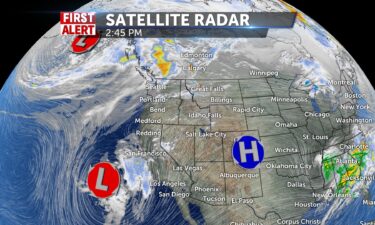
High pressure over the west, still allowing for warming temperatures this workweek. A stormy pattern arrives this weekend, with scattered rain and…
Continue Reading
High pressure over the Four corners with above average temperatures this week. Our next chance for snowy weather arrives this weekend, with gusty…
Continue Reading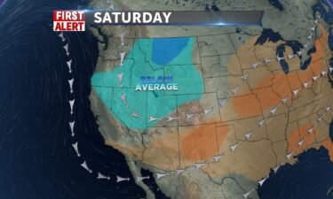
Our potent cold front is exiting the region Friday night, with gusty winds and scattered snow showers. Lows into the teens and 20’s for the Snake…
Continue Reading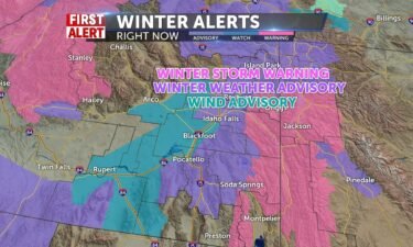

A strong system is moving through the region with gusty winds and scattered snow showers. Overnight, A 40 percent chance of snow, with areas of…
Continue Reading

An area of low pressure is moving towards eastern Idaho for Thursday evening and Friday. Thursday morning will be quiet and cold with light winds.…
Continue Reading
Mostly sun with cold temperatures upper 20’s to just below freezing. Light winds from the north 5-7mph. Bitter cold air tonight takes us below…
Continue Reading