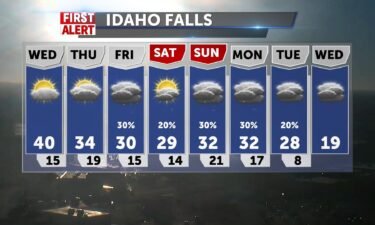
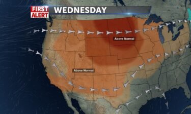
Light Winds, Above Average Temperatures Wednesday, Chance of Snow Friday
High pressure will begin to shrink as we move into Wednesday, as a weak front moves through the Northwest. We’ll see light winds with highs above…
Continue Reading High pressure will begin to shrink as we move into Wednesday, as a weak front moves through the Northwest. We’ll see light winds with highs above…
Continue Reading
We’ll have clouds building by tomorrow ahead of a cold front which will take temperatures to normal seasonal averages (32) into Thursday, but today…
Continue Reading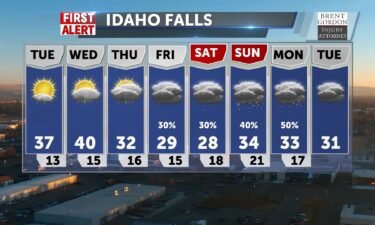
High pressure remains locked into place with an inversion across the region. A weak system passes through Montana this Wednesday with a chance of…
Continue Reading
We will see changes in the forecast by Wed/Thursday with a cold front bring shower chances and cloudiness and dropping temperatures. Until then,…
Continue Reading We’ll be able to climb from the single digits overnight into the low to mid teens with highs pushing toward 40 for most and lower 40’s for Pocatello.…
Continue Reading
Very little wind and vertical mixing are keeping some pollutants near our surface, which puts us under an Air Stagnation Advisory. Please keep…
Continue Reading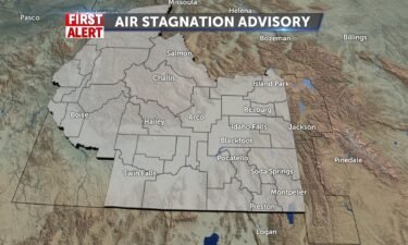
A ridge of high pressure remains in place through Sunday morning. With this ridge, we’ll continue to see an inversion. An inversion is sinking air,…
Continue Reading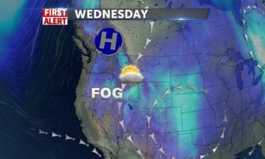
High pressure will strengthen over the region this week, behind Monday’s cold front. Light winds and temperatures into the 20’s and 30’s for daytime…
Continue Reading After the front with some snow for the mountains and a little dust in the valley last night, cold air drops in and we’ll feel about a 8-10 degree…
Continue Reading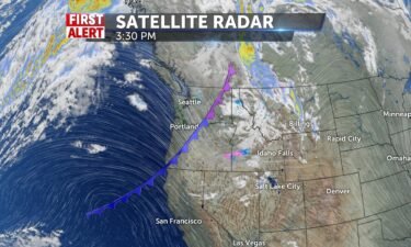
A cold front is moving through Idaho and Wyoming Monday evening, with scattered snow showers and gusty winds. Behind this cold front, we’ll see cold…
Continue Reading Monday will bring more cloudiness into the day and Salmon will begin to see the effects of a cold front by lunch with light snow and windier…
Continue Reading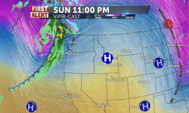
A cold front is moving out of the northwest for Monday afternoon and evening. We’ll look for afternoon winds into the 10-20 MPH range, with…
Continue ReadingHigh temperatures will trend above freezing over the weekend. Warming climaxes Monday with high’s around 40 ahead of a…
Continue ReadingDon’t expect anymore snow for the next several days. A slow warming trend will just see highs into the upper 30’s by Monday, ahead of our next…
Continue Reading
Showers to the SE dissipate this morning by the time you wake up then fog burns out for some sun this afternoon. Snowy slick spots on many roads, so…
Continue Reading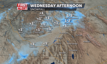
A cold front is making its way east into Wyoming for Wednesday night. With the winds from the north, we’ll see a upper Snake River Plain convergence…
Continue Reading Slick spots can make for hazardous travel. Jeff Roper KIFI KIDK will have what’s happening now, what’s new, and what’s next for your holiday travel…
Continue Reading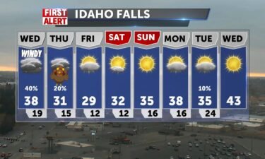
We’re seeing some low clouds Tuesday evening, leading to some snow flurries and light snow showers. A Pacific Northwest storm system moves in…
Continue Reading Idaho and Wyoming with freezing drizzle fashizzle and fog this morning, then some sun may show up for central mountains and other spots before a…
Continue Reading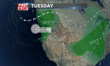
A cold front is moving off to the east tonight, with just a few isolated snow showers with gusty winds. Overnight, look for a slight chance of snow,…
Continue Reading Winds will shift to the SW-6 by lunch and you may see a snow shower skiff across Pocatello, Driggs and Jackson midday to afternoon. Highs from 35-40,…
Continue Reading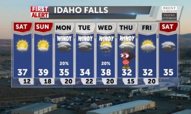
Temps will be slightly below average this weekend. Light winds with a partly sunny sky. A storm system moves through the Northwest Monday, delivering…
Continue Reading Low visibility with mid-morning fog, then sun all weekend with temps below normal @35-40 for IF/Pocatello. Lows will be cold, singles and teens.…
Continue Reading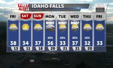
As we get on the other side of this cold front, we’ll see cold temperatures, sunshine and lighter winds. We still have a few spotty snow showers with…
Continue Reading Windy day with highs stuck in the mid to upper 30’s near 40 and a slight chance for a small rain/snow shower. Our clearing process begins with lows…
Continue Reading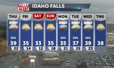
Rain and snow showers with us Wednesday night and Thursday as a cold front moves through the region. We’ll see dropping snow levels overnight with…
Continue Reading We’ll have a chance for some rough wintry weather this afternoon into the upper SRP, winds will pick up with a rain/snow mix into the valley edges…
Continue Reading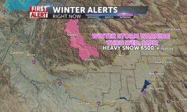
We’ll have a chance for some rough wintry weather this afternoon into the upper SRP, winds will pick up with a rain/snow mix into the valley edges…
Continue Reading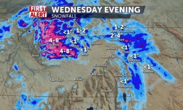
A storm takes aim to our region, late Tuesday night into Wednesday. We’ll see mountain snow, valley rain and snow showers. A Winter Storm Warning has…
Continue Reading Another Pacific storm system will affect the central mountainstonight through Wednesday evening. Snow levels will be elevatedin the 6 to 7 thousand…
Continue Reading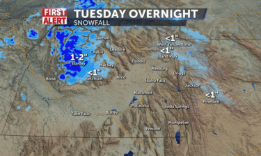
Slightly warmer and dry weather, before another storm rolls in Tuesday night. We’ll have temps into the 40’s and 50’s for Tuesday, with a Pacific…
Continue Reading Temperatures are more normal today with a brief window for a mid-morning shower in the plain and areas around Rexburg and Driggs to Western Wyoming.…
Continue ReadingExpect a few scattered showers overnight Sunday and into Monday morning. Calmer weather is on the way for Monday and Tuesday with just mild winds,…
Continue Reading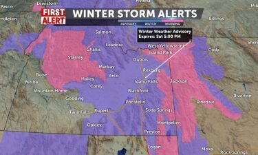
A storm system is making its way through Idaho and Wyoming. Accumulating snow for Friday evening and overnight into Saturday morning. We’ll still see…
Continue Reading Snow is already entering Idaho and we’ll start to see accumulations in the Sun Valley and Arco by lunchtime. Winds of 30mph by afternoon combined…
Continue Reading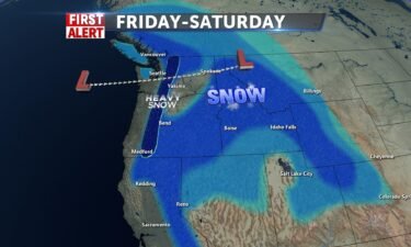
A storm system is approaching form the northwest. We’ll see a slight temperature bump up-ward, before a cold front arrives into Saturday. Areas of…
Continue Reading Nice sunshine for the afternoon, but still cold: 32-36 degrees with upper 20’s in Jackson. Clouding up tonight with cold lows in the teens. Another…
Continue Reading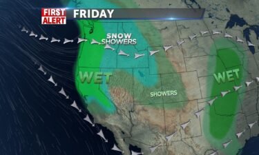
Scattered snow showers for Wednesday night, with a clearing, cold forecast for Thursday. We’ll see mostly cloudy skies Wednesday night, with clearing…
Continue Reading Another round of snow today with a winter weather advisory for Salmon, and mountains to the north and east of Idaho Falls into Wyoming. Jackson area…
Continue Reading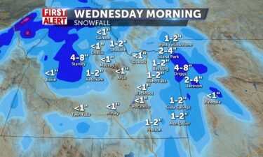
Winter-like weather continues for Wednesday with scattered snow showers, gusty winds and chilly temperatures. We’ll see a bit of a break for…
Continue Reading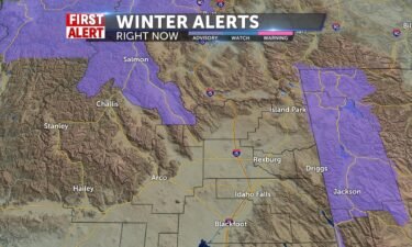
Tuesday and Wednesday give us some potential from some snowfall amounts up to 6-8″ for mountain communities, possible 3″ for the valleys. The wind…
Continue Reading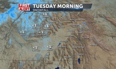
We’re working on another system from the northwest with a risk of snow showers for Monday night, Tuesday and Wednesday. Most of the snow showers will…
Continue Reading 2 systems will bring some snow to the SRP and mountains this week. Flurries starting today with a good chance of snow, 50%, for IF and Pocatello and…
Continue ReadingTemperatures will stay below freezing through most of the work week, with highs into the low 30’s and lows into the 20’s and teens. Conditions stay…
Continue Reading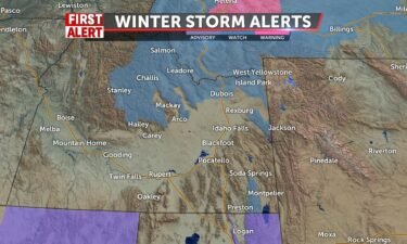
Winter-like weather for this weekend, as a storm system moves in from the west. Showers will begin to fall into Saturday afternoon, with rain turning…
Continue Reading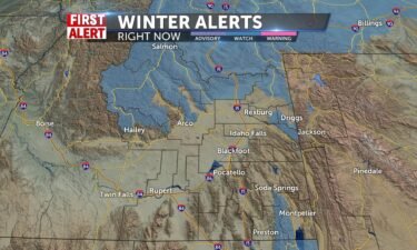
WINTER STORM WATCH IN EFFECT FROM SATURDAY EVENING THROUGHSUNDAY EVENING… * WHAT…Heavy snow possible. Total snow accumulations of 2 to 5inches in…
Continue Reading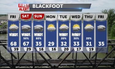
Near record warm temperatures, will once again be with us for Friday, with increasing winds. A significant storm system rolls into the region…
Continue Reading Winds pick up, clouds move in and we get warmer tomorrow, before a rainy Saturday and snowy Sunday give us a rude awakening for November. Highs close…
Continue Reading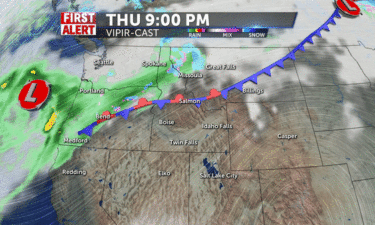
Warm, dry and breezy, under the influence of high pressure for Thursday. Overnight lows back into the upper 20’s to lower 30’s for the Snake River…
Continue Reading
High pressure will remain in control for our weather for the next few days, before a storm system arrives this weekend. Wednesday, partly sunny with…
Continue Reading 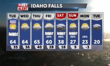
High pressure over the west with warming temperatures. A dry cold front for Tuesday, will drive in some winds with highs well into the 60’s. We’ll…
Continue Reading We start November with highs in the mid to upper 60’s and light breezes from the NNE-5. This trend continues through Thursday ahead of a storm system…
Continue ReadingHighs will move back up toward 60’s for Sunday and Monday. Expect mild breezes and frosty overnight…
Continue Reading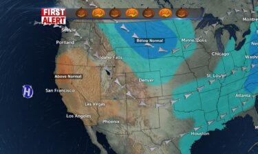
A cold front is moving through this evening, with a few showers possible around Salmon. However, this is a mainly dry cold front with gusty winds…
Continue Reading
A cold front from the northwest will drive in winds for Friday afternoon. We’ll also see a slight chance of showers for areas of Central Idaho and…
Continue Reading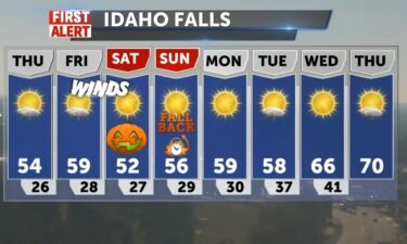
High pressure working into the western states will deliver seasonal temperatures with mainly sunny skies for Thursday. A cold front moving through…
Continue Reading After a couple of chilly days, we’ll start to see normal temperatures for late October. High pressure over the western states will sit over the Great…
Continue Reading 
Another cold night and morning for early Tuesday. We’ll slowly start to warm-up, with high pressure building back into the west. Tuesday, sunny with…
Continue Reading High temperatures will stay below freezing for the next couple of days, with overnight lows falling into the teens and single digits. Daytime winds…
Continue Reading
A strong cold front is approaching for Friday evening into Saturday. Gusty winds will develop late Friday with scattered snow and rain showers. Most…
Continue Reading We have a Winter Storm Warning for Northern Idaho Mountains and around Jackson Hole/Western Wyoming and a Winter Weather Advisory issued for our…
Continue Reading
With clearing skies tonight and cool air in place, we’ll see lows back into the teens through Friday morning. Cool and breezy for our Friday, with a…
Continue Reading North winds today, cold air pushing some early morning snow showers down I-15 as colder air takes us to 40-45 today. 38 in Jackson. Winter Storm…
Continue Reading A vigorous cold front is exiting the region tonight, with calming winds and colder temperatures for Thursday. We’ll see a few isolated snow and rain…
Continue Reading 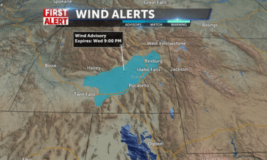
A cold front is on the way for Wednesday, with gusty winds, a few snow and rain showers, and dropping temperatures for the later-half of the week. A…
Continue Reading 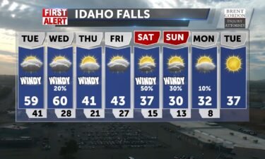
Our northwest flow will continue to deliver gusty winds locally and a shot of rain and snow this Wednesday. The Wednesday cold front will drop in…
Continue Reading A few windy seasonal days before a system pushed deep into Idaho and creates colder temps and slight shower chances mid-week. Lows get into the 20’s…
Continue Reading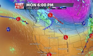
It will stay windy for much of this workweek, with this continued northwest flow. The Jet-stream is still right overhead, keeping the…
Continue Reading 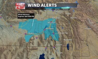
The jet-stream is ushering in several frontal systems from the northwest. We’ll keep gusty winds in the forecast well into next week. Saturday,…
Continue Reading 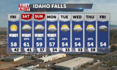
Winds will pick-up for Friday afternoon, as another frontal system slides down the jet-stream. We’ll have a slight chance of showers this weekend…
Continue Reading 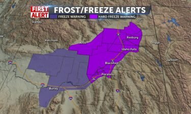
With our exiting cold front, we’ll see freezing temperatures overnight into Thursday morning. The National Weather Service, has issued a Hard Freeze…
Continue Reading Cooler today with a wind advisory for the lower Snake River Plain, blowing dust, but mostly sun. Highs 53-55. Upper 40’s in the mountains. SW Winds…
Continue Reading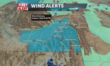
An exiting cold front will drop our temperatures, keep windy conditions and sprinkle in some isolated showers. The National Weather Service has…
Continue Reading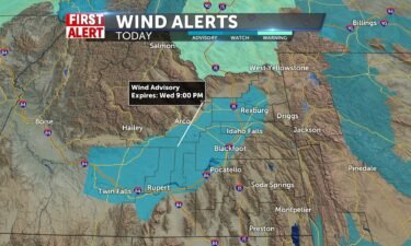
.WIND ADVISORY NOW IN EFFECT FROM NOON TODAY TO 9 PM MDT WEDNESDAY… * WHAT…Southwest winds 25 to 35 mph with gusts near 50 mph expected. Winds…
Continue Reading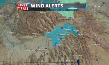
A couple of cold fronts are moving through the region, with high winds and scattered rain/snow showers. A Wind Advisory has been…
Continue Reading Expect 30 mph constant winds this afternoon with blowing dust along I-15 and gusts of 40-45 mph through early evening (8pm). Sun and fall like…
Continue ReadingA cold front sweeping through overnight is ushering in more winter-like conditions. Expect valley rain, mountain snow and persistent…
Continue Reading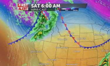
A cold front pushes through for Saturday, with increasing clouds, gusty winds and scattered showers late into Sunday. The National Weather Service…
Continue Reading 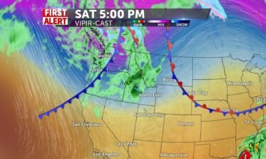
Winds begin to calm a bit overnight into Friday morning. We’re working in more smoke and warm temperatures from the southwest, before a storm moves…
Continue Reading Smoky sun and 76-80 today with winds from the SW gusting to 20+. Wind speeds constant at 10-13mph into the afternoon. A cold front this weekend moves…
Continue Reading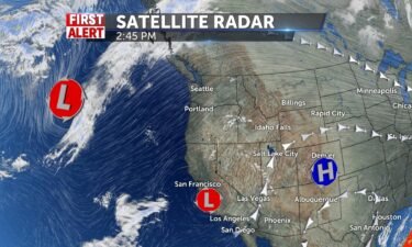
We still have much of the same weather pattern lined-up for Thursday. However, we’ll look to add in some breezy winds for the afternoon hours. Still…
Continue Reading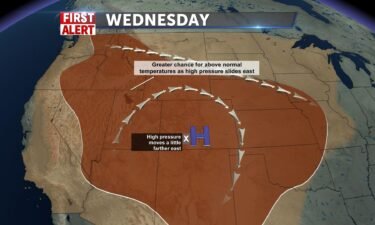
Our ridge of high pressure will begin to shift east, allowing for even warmer temperatures and smoke being pushed in from the west. By this Saturday…
Continue Reading Warming up the next few days with haze on the return. Highs will be 77-81 with light winds from the SW 5-10. We’ll get a break from the haze but it…
Continue Reading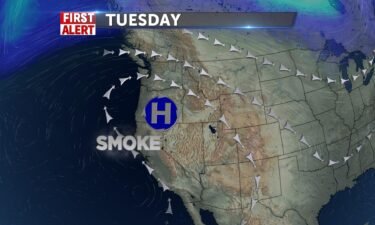
High pressure over the region, will keep temperatures above average. Humidly levels are also staying dry for start of the workweek. Smoke continues…
Continue Reading We’ll cool things down just a few degrees Monday, and see highs into the low 70’s. Expect mid-70’s through Thursday before a cold front slides in…
Continue ReadingMore warm weather is scheduled throughout the week. High temps could graze low 80’s, Sunday. Widespread 70’s are expected through…
Continue Reading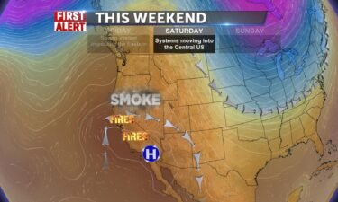
A few clouds tonight, thanks to a system moving through eastern Wyoming, South Dakota and Nebraska. We’ll look for more smoke drifting in from the…
Continue Reading A trough from the north swings by for Friday and brings us a slight decrease in highs, and increase in clouds, but we’re not far from today. It will…
Continue Reading
A strong ridge of high pressure will continue its slow slide south this Friday and Saturday. We’ll still see above average high temperatures with…
Continue Reading