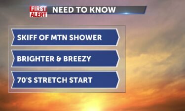
Tracking more sun and wind
A few shower chances push up against the ridges and hills as low pressure eases out of the region. High pressure dries us out and winds will…
Continue Reading A few shower chances push up against the ridges and hills as low pressure eases out of the region. High pressure dries us out and winds will…
Continue Reading
For Tuesday evening, there is a chance of showers and thunderstorms. Partly cloudy with a low temperature in the lower 40’s. Northeast winds around…
Continue Reading
We are definitely cooler today with highs in the 60’s. after the cold front yesterday we popped thunderstorms and got a taste of the spring time…
Continue Reading
A disturbance from the northwest is ushering in the threat for thunderstorms and gusty winds. For Monday night and early Tuesday, there is a chance…
Continue Reading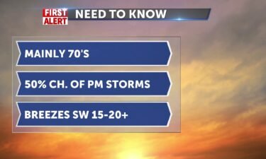
We’ve got a milder week ahead with some upset conditions this afternoon and a 50% chance of thunderstorms. Winds today 10-15 gusting to 20+mph. Highs…
Continue Reading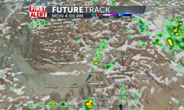
Stray rain showers start off the day for Monday morning leading to more frequent isolated groups of rain showers and thunderstorms building into the…
Continue Reading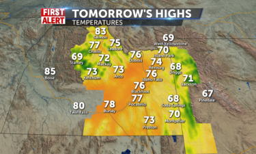
Sunshine and blue skies are expected throughout…
Continue Reading
High pressure over the northwest will keep us mainly dry and warmer this weekend. Mostly sunny for Saturday, an isolated thunderstorm is possible,…
Continue Reading
Thursday night, there is a slight chance of showers and thunderstorms with gusty winds and low temperatures in the mid 30’s. Winds will slowly die…
Continue Reading
Low sliding 4 inches of snow to Henry’s Lake overnight as it wobbles and pushes a slight chance of showers back into our backyard today. Grab your…
Continue Reading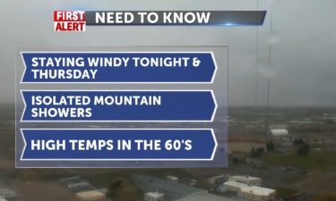
Overnight, partly cloudy with showers slowly ending. A low temperature in the mid 30’s, with north winds around 15-25 mph. Mostly sunny for…
Continue Reading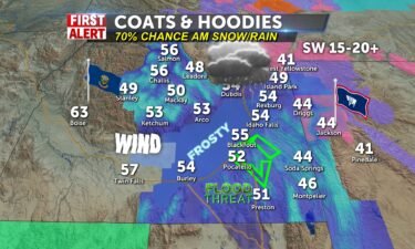
We are on the edge of heaven, just hang on until we can get the last rounds of rain/snow through the valley. Highs 55 with a chilly start in the…
Continue Reading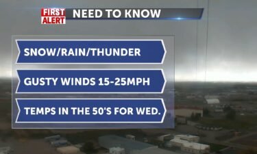
Overnight into Wednesday morning, there is a chance of snow and rain showers. A low temperature in the lower 30’s. Mostly cloudy with winds at…
Continue Reading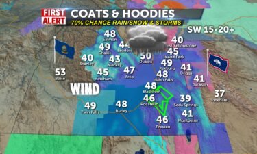
We’ve got a 70% chance of rain/snow showers and winds today highs flirting with 50 degrees. Wind advisory for the the lower valley 30-50mph winds…
Continue Reading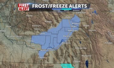
An area of low pressure is with us through Tuesday. The National Weather Service has issued winter weather advisories and winter storm warnings for…
Continue Reading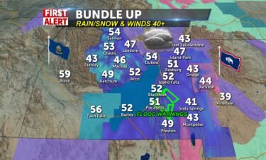
Bumpy weather to start mixing rain with snow and winds picking up 30-55mph. We’ll take 30’s this morning into the low-to-mid 50’s for…
Continue Reading
Scattered rain and snow showers hit the region throughout the day Monday especially in the morning…
Continue Reading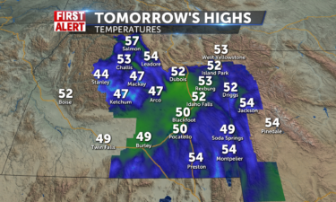
It will be a messy Sunday with scattered valley rain and mountain snow showers starting early in the morning and carrying throughout the entire day…
Continue Reading
Sunshine and blue skies finally await us for…
Continue Reading
Last of the rain/snow showers dart to the south and east of us for the highlands and mountains. Winds shift to SW 10-15 and more sunshine into the…
Continue Reading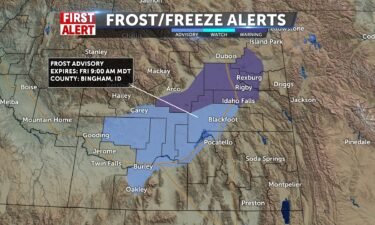
FREEZE WARNING REMAINS IN EFFECT FROM 2 AM TO 9 AM FRIDAY:Sub-freezing temperatures as low as 29 expected. Frost and freeze conditions could kill…
Continue Reading More clouds and unsettled waves of showers expected into tonight, but slightly warmer today for this National Day of Prayer, May 2. Our day today…
Continue Reading
FREEZE WARNING IN EFFECT FROM 2 AM TO 9 AM THURSDAY: WHAT…Sub-freezing temperatures as low as 24 expected. WHERE…Eastern Magic Valley,…
Continue Reading
Snow and rain showers flying this afternoon and winds beyond 30mph at times. Slick conditions with no accumulations expected, but water levels…
Continue Reading
After a beautiful start this morning, we’ll see temperatures close to the upper 40s around 50° for some then we get a chance of rain and snow very…
Continue Reading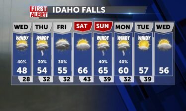
We have a low-pressure system moving through north Idaho and Montana. This will keep us windy and help drive in a chance of wet weather. The National…
Continue Reading
We’ve got a new advisory this morning. In addition to the freeze warning for the valley through 9am, in which you should protect your plants, we are…
Continue Reading
The National Weather Service has issued a Freeze Warning for the eastern Magic Valley and the Snake River Plain. For early Tuesday morning,…
Continue Reading
Scattered mountain mixed rain and snow showers will be spread out across central ID and western…
Continue Reading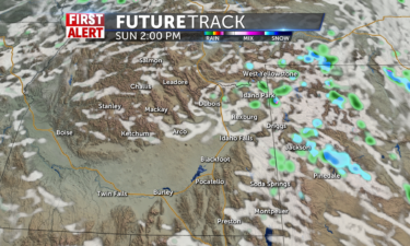
We are only expecting a few groups of isolated rain and even fewer snow showers out for the extreme Upper Snake River Plain and for western…
Continue Reading
Another system moves in for Saturday, look for more wet weather. We’ll have a few leftover showers possible for Sunday. Late Friday and early…
Continue Reading
Isolated thunderstorms continue to roam the region tonight, especially across areas of the Upper Snake River Plain. A chance of showers, with…
Continue Reading
Isolated thunderstorms are expected again throughout all of…
Continue Reading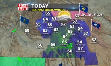
We’ve got a cold front across the I-15 corridor and more rain scattered today with highs in the mid 60’s. Gusts to 25 with wind from the southwest.…
Continue Reading
For Wednesday night and early Thursday morning, we’ll see a slight chance of thunderstorms and showers. Mostly cloudy skies, overnight low…
Continue Reading
Isolated rain showers and thunderstorms carry on throughout the entire day on…
Continue Reading
We’ve got those low 70 temperatures set up for us today as a low approaches and another push of cold air comes across the area by later. This will…
Continue Reading
Overnight, partly to mostly cloudy skies with a low around 39°. Light winds overnight around 5 mph. Mostly sunny for Wednesday with high…
Continue Reading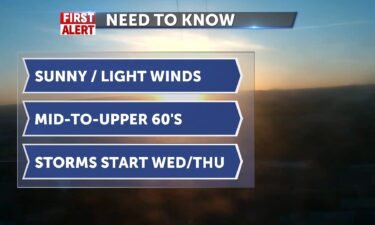
There is a decent warm up before we storm up as conditions change by tomorrow midday. Lighter winds today with high ridge over us and calmer winds, w…
Continue Reading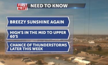
Overnight, partly cloudy with low temperatures in the mid 30’s for the Snake River Plain. Northeast winds around 10-15 mph. Mostly sunny for…
Continue Reading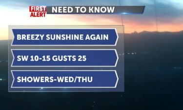
Sunday’s cold front jacked up the winds to 58mph in Idaho Falls and we hit a high of 71. Today will not be as extreme, but we’re setting up another…
Continue Reading
Mostly sunny to completely sunny conditions are out for Monday with no chances for any rain at…
Continue Reading
There is about a 20-30% chance of seeing a few light rain showers along the Continental Divide and into western WY for…
Continue Reading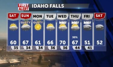
High pressure overhead will lead to quiet weather for Eastern Idaho and Western Wyoming. We’ll see this high pressure get pushed further east for…
Continue Reading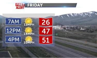
Upper level flow to the south brings us consistent for the Rockies and mountain showers (slim shady chance). Winds will be brisk and from the north…
Continue Reading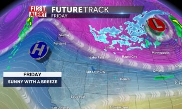
High pressure is slowly working in from the west. We still have a few isolated showers possible, across the central mountains, along the Montana…
Continue Reading
Olaf had his 15 minutes yesterday after snow and rain put a damper on Wednesday, closing the Teton Pass last night and 8″+ for Grand Targhee. Our…
Continue Reading
Overnight, there is a slight chance of snow with mostly cloudy skies. A low temperature in the mid 20’s for the Snake River Plain. North northeast…
Continue Reading Today will be one of the coldest days in the last couple of…
Continue Reading
Mostly cloudy Tuesday night and early Wednesday, with a low around 38°. Southwest winds around 15 to 25 mph, with gusts as high as 40 mph. For…
Continue Reading
Partly cloudy skies to start this morning. Morning winds coming from the south southwest around 11 to 13 mph, with gusts as high as 18…
Continue Reading
One area of low pressure over Utah is slowly pulling away, but we have another area of low pressure to the north. Staying windy overnight into…
Continue Reading
A few stray rain showers start off Monday morning with more scattered heavier rain showers in the…
Continue Reading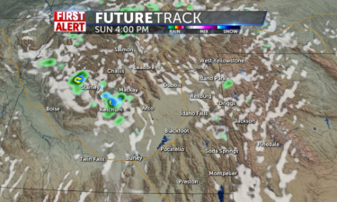
Mostly sunny skies are expected for Sunday especially in the…
Continue Reading
We have a slow-moving area of low pressure to our west. This is helping in steering warmer air from the southwest, along with breezy conditions.…
Continue Reading
Mostly clear overnight into Friday morning, with a low temperature in the upper 30’s. South southwest winds 10 to 15 mph becoming north northeast…
Continue Reading High pressure remains in control once again today with no weather impacts expected. Aside from a few high clouds from time to time, skies will be…
Continue Reading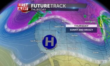
Mostly clear overnight, with a low temperature in the lower 30’s. South southeast winds 5 to 10 mph. Sunny for Thursday with a high in the lower…
Continue Reading IDAHO FALLS, Idaho (KIFI) – Today and Thursday a ridge of high pressure will continue to amplify over the region for the next few days. This means we…
Continue Reading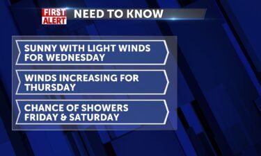
Overnight there is a chance of showers. A low temperature in the lower 30’s for the Snake River Plain. Southwest winds around 10 to 15 mph, with…
Continue Reading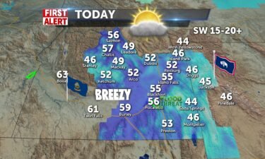
We’re tracking some showers to the north and we’ll have winds from the south 15-25mph today. The sun and moon still available for viewing, just not…
Continue Reading
As we shake off the wet weather from the weekend, we’ll see a few isolated mountain showers. We’ll also see breezy winds through the entire…
Continue Reading
40-50% eclipse coverage for eastern Idaho and western Wyoming and with sun out, there will be some light breezes and high temps climb to upper 40’s…
Continue Reading
Sunshine and blue skies await us for…
Continue Reading Rounds of rain and snow tonight as temps drop to 29. Winds will be gusty at times up to 30mph. Sunday chances of snow at 30% in the afternoon.…
Continue Reading
Scattered showers and thunderstorms for Friday night into Saturday. For Saturday, we’ll see a chance of snow showers before 3pm, then rain showers…
Continue Reading
Wind Advisory for lower snake plain with gusts over 30mph along I-86 and I-84. Cresting expected tonight for the Portneuf River, which means a flood…
Continue Reading
Gusty winds for the overnight, with a few isolated thunderstorms in central Idaho. Partly cloudy in the Snake River Plain. South southeast winds 20…
Continue Reading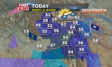
Partly sunny, with a high near 66. South wind 15-30 / gust to near 40 Low tonight 41 S winds tonight 20-30/gusts to near 40 Friday has mid-morning…
Continue Reading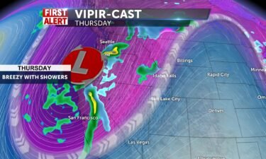
We’ll see a few showers and thunderstorms for central and southern Idaho, while the Snake River Plain will stay mainly dry and clear for Thursday.…
Continue Reading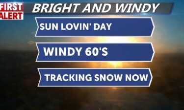
Sunshine and high of 65 with winds cruising from the southwest 15-20+, gusting up to 25. Partly cloudy skies tonight with no interruption , just…
Continue Reading
Sunshine and high of 65 with winds cruising from the southwest 15-20+, gusting up to 25. Partly cloudy skies tonight with no interruption ,…
Continue Reading
Our warming trend continues under a large area of high pressure, with low pressure slowly pushing in from the west coast. As this area of stormy…
Continue Reading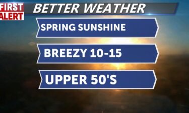
We’ve got a nice bright day ahead, giving you a major taste of spring. Sunshine and highs approaching 59 with winds cruising from the southwest…
Continue Reading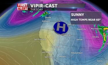
Mostly clear skies overnight with a low temperature in the upper 20’s. Light winds from the southwest, around 10 mph. Sunny for Tuesday with a high…
Continue Reading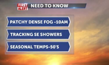
With the weekends record-setting rainfall, .33″ in Idaho Falls yesterday, we’ve got alot of moisture and that creates the fog this morning. We’re…
Continue Reading
Sunshine is back out with partly cloudy conditions. There is a slim chance of mountain snow showers for western WY and SE ID that could still be…
Continue Reading
Scattered rain and snow showers will cover the region throughout most of the day especially in the…
Continue Reading
Friday night, there is increasing cloud cover with a chance of snow. A low temperature around the lower 30’s. Scattered snow and rain for Saturday…
Continue Reading
After 58mph winds at PIH yesterday morning, we will calm things down for today. Highs 45-50 and winds 10-15+. Some high light clouds and breaks with…
Continue Reading
A large area of low pressure is moving south along the west coast. We’re not seeing a lot of moisture for Friday, but we expect a larger push of…
Continue Reading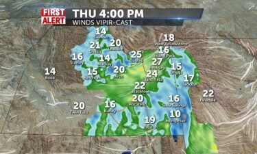
More windy conditions for the afternoon in the wake of a cold front, that seemed more like a wrestling match with the groundhog and mother nature.…
Continue Reading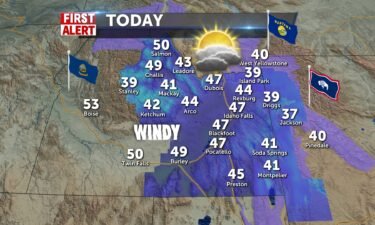
As the front comes across the I-15 corridor this morning, winds will be harsh. We advise caution when traveling. Some unsettled conditions (…
Continue Reading
Overnight, we have an approaching cold front that will drive in rain and snow, along with gusty winds. Cloudy skies, with a low temperature around…
Continue Reading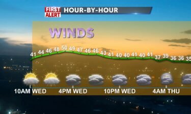
A windy and cloudy Wednesday. A break from showers today, tracking a storm from the Pacific which will give us central mountain showers later tonight…
Continue Reading
Overnight, there’s a chance of snow under mostly cloudy skies. A low temperature in the upper 20’s, with southwest winds around 10-15 mph.…
Continue Reading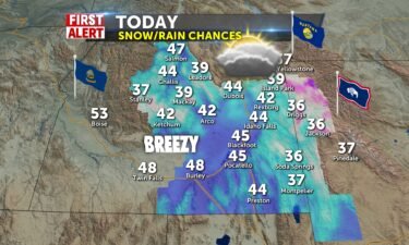
Scattered snow and rain with breezes 10-15. We’ll settle the weather down for Wednesday and Thursday becomes the First Alert weather day for us.…
Continue Reading 30% chance of rain/snow with partly sunny conditions and 46 today. Winds SSW 10-20+ 20% chance of snow after 8pm and 27 overnight. Brisk…
Continue Reading
We’re under this un-settled flow from the northwest for Tuesday. We catch a brief break for Wednesday, before another push of wet weather arrives.…
Continue Reading
Chance of snow 30% partly sunny, with a high near 44. NNW 5-10+ More clouds tonight 27. 30% chance of a wintry mix Tuesday midday. Mostly…
Continue Reading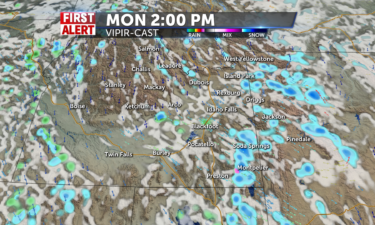
Isolated mixed showers continue into Monday throughout the day with rain showers in the valleys and snow showers in the…
Continue Reading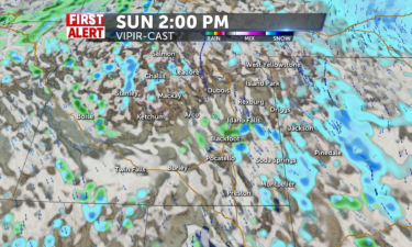
Isolated mixed showers carry on into Sunday with rain showers in the valleys and snow showers in the…
Continue Reading
Chance of showers is limited into tonight with more rain around tomorrow and even the risk of a thunderstorm in the afternoon. Snow for highlands…
Continue Reading
Cloudy skies are across the region for today with a couple of rain showers forming later for Friday…
Continue Reading
Shortwave over the region putting winds over 40 mph for Idaho Falls this afternoon. Winds will calm into tonight and lows will be above freezing for…
Continue Reading
Shortwave over the region putting winds over 40 mph for Idaho Falls this afternoon. Our showers removed from most metro areas, to the north and…
Continue Reading
Isolated snow showers, rain showers, and even thunderstorms will target central ID and the extreme Upper Snake River Plain for the morning moving…
Continue Reading
WE HAVE HAD ANOTHER BRIGHT DAY FOR THE FIRST DAY OF SPRING. TONIGHT WILL BE CRISP WITH LIGHT WINDS AND 35 IN THE VALLEY. WE’LL SEE MORE MELTING…
Continue Reading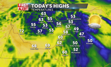
Mostly dry conditions with mostly sunny to partly cloudy skies are ahead for…
Continue Reading
Another winner of day and a chilly night ahead with clear conditions. lows tonight around 29 will be below freezing and with winds 5-10 mph, it will…
Continue Reading