Wintry Weekend Kickoff
Overnight showers add to our frozen landscape make for a slick beginning to Friday. Scattered showers into the midday continue with southwestern…
Continue Reading Overnight showers add to our frozen landscape make for a slick beginning to Friday. Scattered showers into the midday continue with southwestern…
Continue Reading
A system is moving through the region, with scattered snow showers and gusty winds. We’re looking to keep the heavier bands of snow into the higher…
Continue Reading
A slight chance of snow tonight with light winds and lows into the single digits. For Thursday, look for increasing clouds and winds around 10 MPH.…
Continue Reading
Our cold and wet northwest flow continues for Wednesday. We’ll see colder temperatures over the next couple of days with winds 10-20 MPH. We’ll also…
Continue Reading

Our northwest flow will continue with mountain snow showers and dropping temps for Tuesday and Wednesday. We’ll have a few isolated snow showers for…
Continue Reading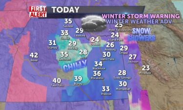
Storm 3 of 3 in the last 5 days pushes more snow into the valley today and more into the highlands and central mountains tomorrow. Snow showers…
Continue Reading
Special Weather Statement from the National Weather Service in Pocatello: Snow to return to southeast Idaho overnight and Monday… Another Pacific…
Continue Reading
This northwest flow of wet cold weather continues with cold air spilling in from the north. Look for scattered snow showers and dropping temps this…
Continue Reading
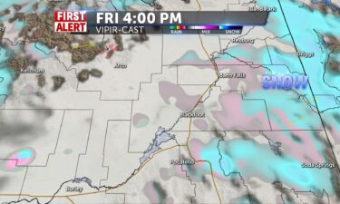
Our wet weather pattern from the northwest continues for Friday and Saturday. Most of the heavy snow will hit east of the Snake River Plain. Friday…
Continue Reading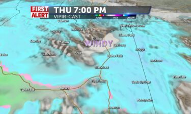
Snow in the mountains, with some rain for the lower Snake, the snow north and east of Pocatello. Winds 10-20+ from the SW, calming tonight, with snow…
Continue Reading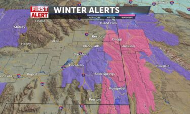
Scattered snow and rain showers will slowly begin filtering through the region by Thursday afternoon into Friday and Saturday. Winds will still be…
Continue Reading 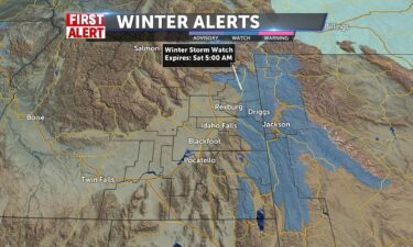
We’ll see Pacific moisture and a Canadian cold front run through the region for this late-week. Winds will pick-up this Wednesday, with wind speeds…
Continue Reading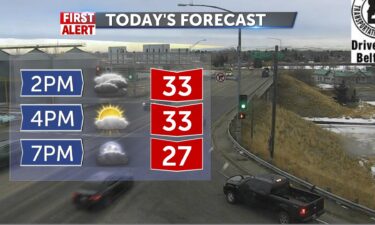
Mid 20’s in the upper highlands today, 32-41 in the SRP and 26 in Jackson. Mountain shower chance exists, partly sunny elsewhere with winds 15-20+…
Continue Reading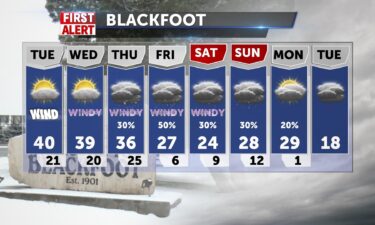
Light snow in the mountains, with partly to mostly cloudy skies in the the Snake River Plain. Winds for Tuesday will be into the 10-15 MPH range,…
Continue Reading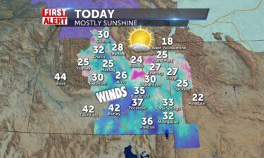
Windy for Monday and temperatures fall as we get snow chances later in the week. Southeastern highlands begin tuesday with a snow chance and some…
Continue Reading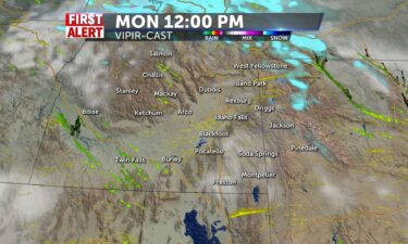
We’re still under our northwest flow, keeping a slight chance of mountain snow in the forecast for Monday. Winds are expected to be lighter, but…
Continue Reading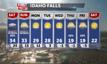
We’re still expecting a push of wet, windy weather out of the north for Saturday and Sunday. We’re keeping a slight chance of snow in the forecast…
Continue Reading A system out of the northwest will usher in scattered snow showers and gusty winds. We’ll see most of the snow favor locations near the Wyoming…
Continue Reading Fingers cross for a glimmer of sun between fog and clouds to start today, winds pushing 15-20+ from the southwest. Highs short of freezing and 33 in…
Continue Reading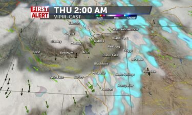
As our storm system exits the region tonight, look for freezing overnight and daytime temperatures into the teens and 20’s. We’ll still have a few…
Continue Reading
Click here to vote for April’s…
Continue Reading
Snow and rain with winds of 20+mph, slick spots so be cautious. Some sun may appear later and highs not much past freezing. Lows tonight in the…
Continue Reading
A Pacific storm is moving through the region tonight and Wednesday morning. Expect scattered snow showers early Wednesday, with partly to mostly…
Continue Reading
Milder temps today with a sun/cloud mix, so you may see YOUR shadow, but a front into evening for the central mountains kicks off the snow for…
Continue Reading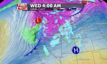
A Pacific system is taking aim to our region this mid-week. Snow is expected to arrive late Tuesday and ealy Wednesday, with gusty winds and…
Continue Reading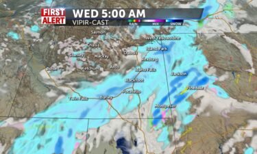
Mostly sunny today with highs in the mid 30’s @36 for IF, Arco, Mackay. Pocatello will reach lower 40’s with N winds 5-10mph. Tuesday night ushers in…
Continue Reading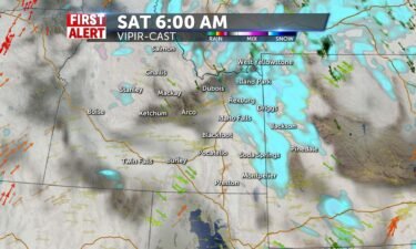
Our slow moving storm system is making its last mark on the region with scattered rain and snow showers tonight and Saturday morning. We’ll see highs…
Continue Reading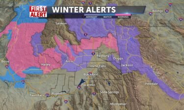
Mostly cloudy tonight with scattered rain and snow showers. Lows into the upper 20’s to lower 30’s, with winds around 10 MPH. For this Friday, we’re…
Continue Reading The first full moon of the year will light up the night sky on Thursday. The moon will be 100% full at 2:16 p.m. ET. Barring clouds or bad weather,…
Continue Reading
More Scattered snow showers and rain with some gusty winds continue into the afternoon. Temperatures in the mid 40’s for the SRP, and low 30’s for…
Continue Reading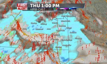
A wet weather pattern continues to move through the region. We’ll see snow and rain showers with slightly warmer temps for Thursday and Friday. We’re…
Continue Reading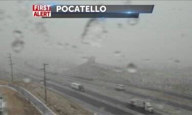
The viewing area gets the snow blast cranked pretty well this afternoon with highs reaching the upper 20’s for mountain areas and lower 30s for the…
Continue Reading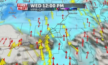
The viewing area gets the snow blast cranked pretty well by mid-morning into lunch with highs reaching the upper 20’s for mountain areas and lower…
Continue Reading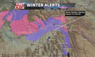
We’re seeing a steady stream of stormy weather roll in from the west. We’ll start to see snow showers moving through the region, Wednesday morning.…
Continue Reading Heavy snow for mountain areas of Eastern Idaho Wed/Thur. Accumulations beyond 12″ for Central mountains, High Country and Jackson and 3-5″ for…
Continue Reading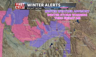
Heavy snow for mountain areas of Eastern Idaho Wed/Thur. Accumulations beyond 12″ for Central mountains, High Country and Jackson and 8″ for…
Continue Reading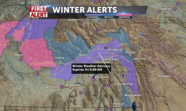
Mostly cloudy tonight, with a few light snow flurries and showers. Lows into the single digits around the Snake River Plain. For Tuesday, partly…
Continue Reading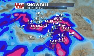
Western Idaho has already been given notice about a river of moisture that will bring substantial snow amounts for the mountain areas beginning…
Continue Reading
High pressure with us tonight will lead to dropping temperatures tonight and Sunday, areas of freezing fog. Overnight lows will drop into teens and…
Continue Reading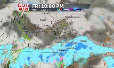
A storm moving through Utah and Nevada will continue to push in snow and rain showers. Most of the wet weather moves through Utah, with some snow…
Continue Reading THE FOREST SERVICE UTAH AVALANCHE CENTER IN SALT LAKE CITY HASISSUED A BACKCOUNTRY AVALANCHE WATCH. UNTIL 6 AM MST SATURDAY. * AFFECTED AREA…THE…
Continue Reading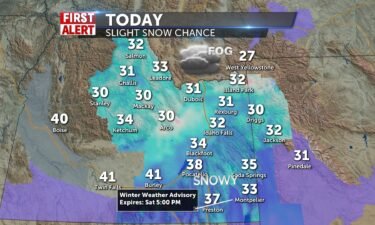
20-30% chances of snow today with patchy fog and winds N-5-10mph. Highs 32-38 from IF to Blackfoot/Pocatello. Winter Weather Advisories for a portion…
Continue Reading
An area of low pressure along the Pacific coast, is sending snow showers in our direction. This low is moving south into Nevada and Utah, with spotty…
Continue Reading 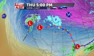
An area of low pressure is moving through the Great Basin over Nevada and southern Idaho. We’ll see a chance of snow late Thursday into Friday and…
Continue Reading Some more sun with a mix of clouds to start the day: Light breezes from the north make wind chills serious this morning. We’ll be partly sunny by…
Continue Reading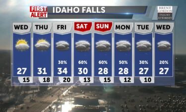
Mostly clear tonight with overnight lows into the single digits for the Snake River Plain. We’ll also see a few spots of freezing fog in the morning.…
Continue Reading
We’ll see mostly cloudy skies for Monday evening, with areas of fog. However, light winds out of the north, will start to move some of this low cloud…
Continue Reading Some low clouds and foggy conditions to begin the day, the upper SRP will have to wait till later to burn this off, then decreasing clouds for sun…
Continue Reading Areas of freezing fog with freezing drizzle and ice. Scattered snow showers for…
Continue Reading
A couple of systems are moving through the Northwest, with scattered snow showers. Most of the snow is favoring the high elevations, with just a few…
Continue Reading 
We have high pressure over the Great Basin with cold overnight lows. Clouds and areas of fog will move into the region for Friday. We’ll have a few…
Continue Reading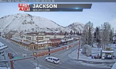
We have cleared out and cold, sunny conditions take over with variable cloudiness through the day and highs in the upper 20’s to near freezing in…
Continue Reading
Staying windy for Wednesday evening, as a cold front exits eastern Idaho and western Wyoming. We’re seeing a few snow showers in our eastern…
Continue Reading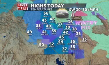
Strong winds accompany the cold front pushing through behind the wintry snow/freezing rain/rain showers scheduled today. SW 35-50+ mph and snow…
Continue Reading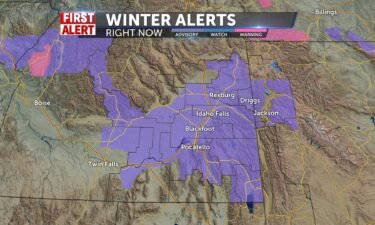
A system moving into the region this evening with rain, snow showers and freezing drizzle. This storm is looking to bring in about 2-4″ of new snow…
Continue Reading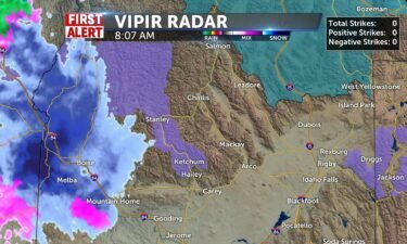
We’ll warm to 32-25 today with some patchy clouds before a messy cold front with rain/snow mix stirs things up for later tonight and into tomorrow.…
Continue Reading
High pressure tonight, leading to cold overnight lows, areas of freezing fog, with a slight chance of snow flurries. Partly sunny skies for Tuesday…
Continue Reading
High pressure makes for a cold start and single digits to begin Monday. Partly sunny by midday and 25-32 highs, with N-6 winds. Clouds from the…
Continue Reading
More cold fronts are passing through the region with un-settled conditions. We have a slight chance of snow for late Friday into Saturday. However,…
Continue Reading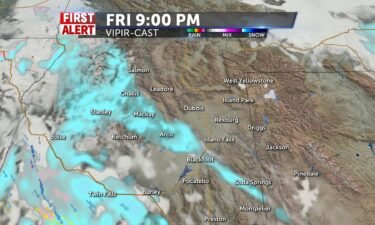
Another weak system pushed through Idaho later today and tonight brings traces of snow for most overnight. Don’t rule out areas of freezing fog and…
Continue Reading
We’ll still have some areas of snowfall Thursday night. With dropping overnight lows, the snow we did see earlier and light winds, we’ll see areas of…
Continue Reading
A weak trough kicks through to start the day and spread some light snow into the area, traces measured before another trough Friday night and…
Continue Reading
A couple of systems are moving through the west, we’ll have a few snow showers for Thursday. Most of the snow showers will favor the mountains, with…
Continue Reading Prepare for a year filled with awe-inspiring reasons to look up at the night sky. There will be full moons, meteor showers, eclipses and planets…
Continue Reading
Areas of freezing fog overnight with a slight chance of snow from that fog, early Wednesday morning. We’ll see near normal highs close to 30° for…
Continue Reading What a difference some sunshine makes! Chilly but sunny this afternoon and temps not much more than freezing. Breezes southwesterly 10-20mph and cold…
Continue Reading
THE GALLATIN NATIONAL FOREST AVALANCHE CENTER IN BOZEMAN HAS ISSUED A BACKCOUNTRY AVALANCHE WARNING. THROUGH 6 AM MST WEDNESDAY. * AFFECTED…
Continue Reading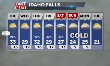
After the last of the snow this morning, winds hit 15-25 from the southwest and we’ll have clearing into the midday and afternoon. Temperatures will…
Continue Reading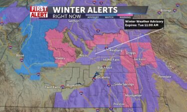
Scattered rain, snow showers for Monday night into Tuesday. We’ll also see gusty winds throughout the region. The National Weather Service has issued…
Continue Reading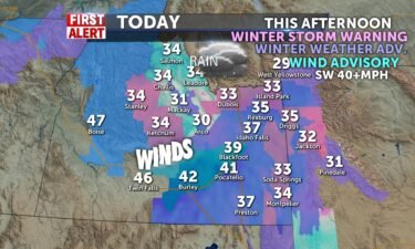
WINTER STORM WARNING REMAINS IN EFFECT FROM 1 PM THIS AFTERNOON TO 11 AM MST TUESDAY… * WHAT…Heavy snow expected. Total snow accumulations of 6…
Continue Reading
A plume of moisture is taking aim to our region with passing rain and snow showers. Winds are expected to increase as well, with the storm arriving…
Continue Reading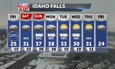
A series of systems will swing through the region over the next few days and well into next week. We’ll see a slight chance of snow Thursday night…
Continue Reading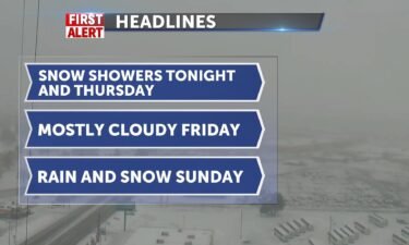
Look for scattered snow showers, light winds through Wednesday night and Thursday morning as a cold front swings in from the west. Another storm…
Continue Reading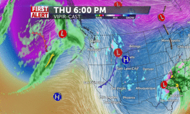
We have a couple of weather systems moving in from the west coast with the first round of snowy weather arriving Wednesday afternoon. A heavier snow…
Continue Reading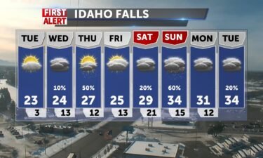
An area of high pressure behind this past weekend’s snow, will deliver cold and mostly sunny skies for Tuesday afternoon. With overnight low’s close…
Continue Reading
IDAHO FALLS, Idaho (KIFI/KIDK) – City officials issued a “snow event” at 9:30 this morning. They do this when the city is blanketed with 2 inches or…
Continue Reading Pacific system brings us chances to accumulate 1-3″ of snow in IF and Pocatello beginnning early tomorrow morning and through the day. A convergence…
Continue Reading Christmas Eve will bring us ultra cold temperatures in the single digits tonight. Northerly winds around 7 will take wind chills into the sub-zero…
Continue Reading 
Traffic separate accidents has caused blockage on two Idaho highways. …
Continue Reading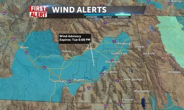
A strong cold front is on the way for Tuesday morning. We’ll see winds picking up to high levels in the mornings with scattered snow showers to…
Continue ReadingScattered showers continue through Sunday night. Mountain areas could see some continued snow into Monday morning. High temperatures will be better…
Continue Reading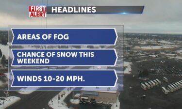
A couple of systems move through the northwest this weekend, with another cold front arriving Monday and Tuesday. First system arrives late Friday…
Continue Reading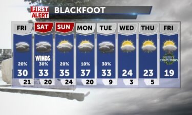
Our Thursday cold front will move off to the east, leaving us with dropping temperatures and a few leftover snow showers. A couple of weaker systems…
Continue Reading More snow today with some rain mixed in due to warmer southerly winds, ending for the SRP around drive time with lingering shower chances into…
Continue Reading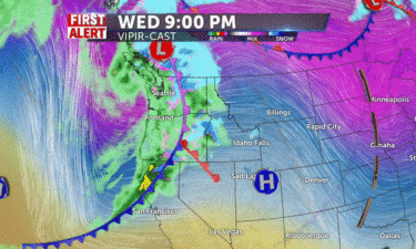
A Pacific storm system moves in for Thursday morning, with scattered snow showers and winds into the 10-20 MPH range. We’ll see snow slowly end into…
Continue Reading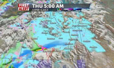
Some snow/wintry mix today with heavy clouds and light mist/freezing fog making for slick and miserable looking conditions. Highs will be warmer than…
Continue Reading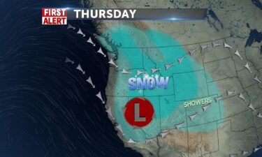
A cold front moving through the region tonight, will lead to scattered snow showers. We’ll look for low cloud cover and fog overnight and Wednesday…
Continue Reading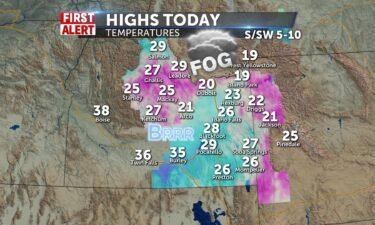
Foggy conditions and cloudy skies make for a dreary day in the region. Highs will be mid 20’s for most and won’t drop much overnight. You can expect…
Continue Reading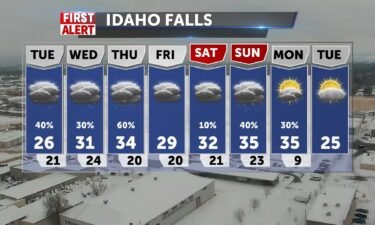
Unsettled conditions stick around this week, as more wet weather systems roll in from the Pacific. Our next storm is expected Tuesday afternoon and…
Continue Reading Slow moving storm system shifting to the south and east could leave several inches of snow. We expect snow to taper off by lunch with temps around…
Continue Reading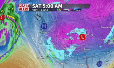
A series of storm systems will slide through the western states. Light snow showers Friday night and into Saturday. More scattered snow showers will…
Continue Reading Snow showers push into late tonight for us with highs only @29-32 and breezes from SW 10-15+mph. Just a cold and grey day with flying snow ending by…
Continue Reading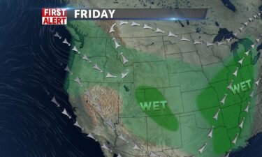
An active weather pattern moves into the region starting Friday and well into this weekend. There will be a slight chance of snow for Friday, with…
Continue ReadingAn initially promising U.S. forecast for the northern lights has gone bust.…
Continue Reading