Snowy and Chilly
Winter weather advisory for central mountains and eastern highland areas through early Friday morning. Light snows bring an additional 1-2″ for the…
Continue Reading Winter weather advisory for central mountains and eastern highland areas through early Friday morning. Light snows bring an additional 1-2″ for the…
Continue Reading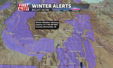
WINTER WEATHER ADVISORY FOR CENTRAL MOUNTAINS AND EASTERN HIGHLAND AREAS THROUGH EARLY FRIDAY MORNING. LIGHT SNOWS BRING AN ADDITIONAL 1-2″ FOR THE…
Continue Reading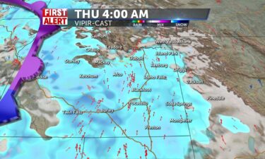
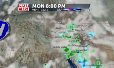
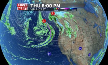
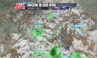
Another round of scattered snow is expected for Thursday as a system moves in from the west. Downslope winds for Thursday, could limit some snow…
Continue Reading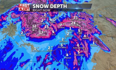
Light snow to start the morning, with frozen elements on windshields, roads, railings, steps, driveaways. Slick conditions everywhere as temperatures…
Continue Reading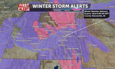
Scattered snow Tuesday night, cold Wednesday, more Snow Thursday TUESDAY EVENING: Scattered snow showers with winds 15-25 MPH, black ice possible,…
Continue ReadingHigh Wind Warning through 3pm for portions of Bingham and Bannock Counties along I-15 ahead of a cold front bringing an artic blast to the region for…
Continue Reading
Cloudy, rain and snow, winter weather advisory now in effect until 5 am tomorrow. Winter Storm Warning for Mountains and Avalanche Warning for…
Continue Reading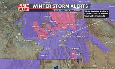
A cold front will move through the region Tuesday. We’ll see gusty southwestern winds ahead of the cold front, keeping temps into the 40’s in the…
Continue Reading Cloudy 40% of snow into the valley, dreery, cloudy and breezy. Temperatures are above freezing this morning for the valley, hence the rain. …
Continue Reading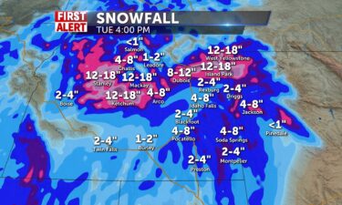
The snow showers will continue to persist into the region until Wednesday if…
Continue Reading
A large system moves through the region, with scattered snow/rain showers and gusty winds. Most of the snow will favor the mountains with minor snowy…
Continue Reading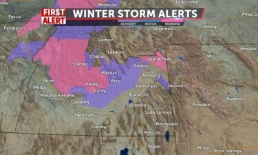
A large Pacific system moves through, with mountain snow on Saturday, more widespread snow and rain activity for Sunday and Monday. OVERNIGHT: Cloudy…
Continue Reading
Morning snow showers linger with some areas receiving more than an inch of snow from I-15 east into the southeastern highlands this morning, give way…
Continue Reading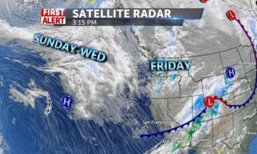
Scattered snow showers for Thursday night and early Friday morning. A weak northwest system will move through for Friday. before a deeper Pacific…
Continue Reading
A cold front for Wednesday evening, is driving in gusty winds and scattered snow showers. A second push of wet weather will move to our south and…
Continue Reading
Snow arrives into mountains for the afternoon and winds today will be gusty at times, SW 15-35 mph. Highs of the valley in the 40’s, cloudy, and wind…
Continue Reading
A cold front is approaching for Wednesday evening with colder air moving down from the North. Tonight, areas of freezing fog with a chance of light…
Continue Reading
We have an active northwest flow, with scattered snow showers tonight, along with some gusty winds. Overnight lows will be just below freezing in the…
Continue Reading
Cloudy, gloomy, windy 20-30mph gusts and blowing snow / rain are all apart of the system that has slowed just enough to weaken the snow chances for…
Continue Reading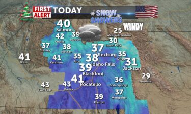
Cloudy with snow showers into today and highs in the 38-41 degrees. Some accumulations for city, more depth for areas east of I-15 and into mountains…
Continue Reading
We are currently and will continue to have very windy conditions from a cold front until tomorrow morning. Winds in the region are mostly being…
Continue Reading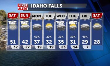
Areas of patchy freezing fog Friday night into Saturday morning. Lows will be back into the upper 20’s for the Snake River Plain, with light winds…
Continue Reading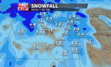
Slow fog burn off this afternoon, some sun and warmth for Friyay and more 50’s for the area. Lows tonight around freezing again and fog will be…
Continue Reading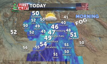
After the fog burns off for Idaho Falls and west of I-15 this morning, some sun and warmth for Friyay and more 50’s for the area. Lows tonight around…
Continue Reading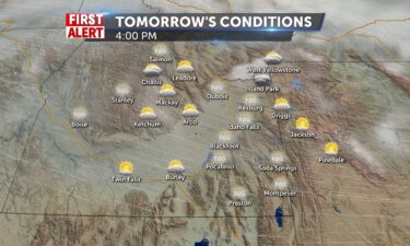
More warmth and sunshine are on the way for tomorrow. Mostly sunny skies will peep out once the fog rolls…
Continue Reading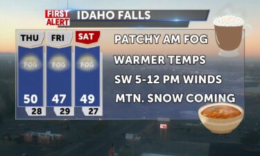
GOOD YAWNING FELLOW BABIES! Morning fog around the area with temps in the 20’s and wc in the upper teens for some. High pressure continues to…
Continue Reading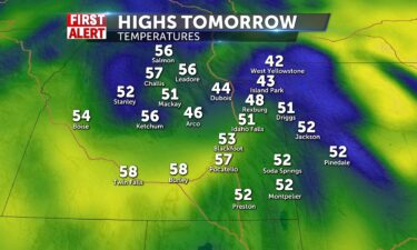
We have another nice day in store for tomorrow. After the fog rolls out, we should mostly sunny to sunny conditions all across our…
Continue Reading
Upper edge of high pressure keeps us in the 50 degree zone today, with some morning clouds across our region. We’ll continue to see lows in the…
Continue Reading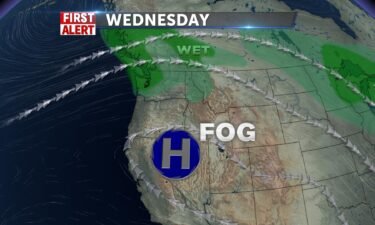
High pressure over the region with stormy weather to our north. We’ll keep the inversion in place for most of the region, with some clouds and…
Continue Reading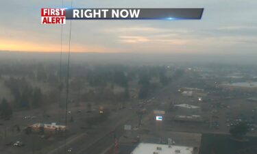
PATCHY DENSE FOG FROM JUST NORTH OF SHOSHONE, NORTHEAST ACROSS THE ARCO DESERT AND SNAKE PLAIN TO NEAR AND JUST WEST OF IDAHO FALLS, NORTHEAST ALONG…
Continue Reading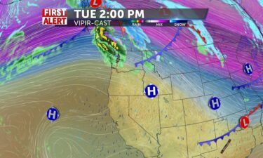
A series of systems to the north, will drive in some wind, warmer temperatures and a few mountain snow showers. Tonight, we’ll see the winds calming…
Continue Reading
Welcome back from the holiday and this week may be drier than your turkey. No precip for the next 5 days with the exception of Salmon area, with some…
Continue Reading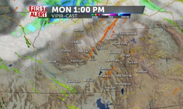
Welcome back from the holiday and this week may be drier than your turkey. No precip for the next 5 days with the exception of Salmon area, with some…
Continue Reading
A nice day awaits us for tomorrow. Partly cloudy skies will be present over the entire region. A stray snow shower might be present in Salmon during…
Continue Reading
The sun continues tomorrow for a beautiful day in…
Continue Reading
We will have a weak system of snow coming through the region today during the morning hours. Central Idaho from Salmon to Stanley is most likely to…
Continue Reading
We are expecting isolated snow showers in central ID over to the way upper part of the Snake River Plain including the towns of Dubois and Island…
Continue Reading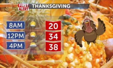
Turkey day will be a good one with mostly sunny skies ahead for most of the…
Continue Reading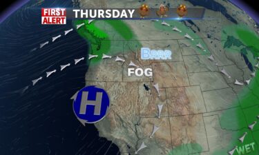
OVERNIGHT: Mostly clear skies with lows into the upper teens and lower 20’s. With winds around 5 MPH and areas of fog. From that fog, we could see…
Continue Reading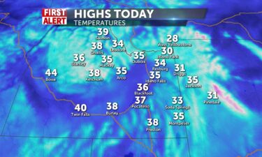
We will have some isolated snow showers present in SE Idaho all the way up to Pocatello and in western WY including the Tetons in the morning…
Continue Reading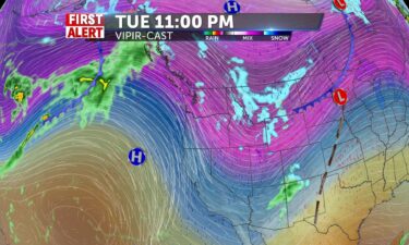
A cold front tonight, will usher in scattered snow, gusty winds and dropping temperatures. TONIGHT: A chance of snow with winds 20-30 MPH, gusts…
Continue Reading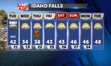
A cold front is on the move for Tuesday, with a few snow showers, gusty winds and dropping temperatures. OVERNIGHT: Mostly clear with lows into the…
Continue Reading
After some morning fog in the Upper Snake River Plain, we should all see mostly sunny skies throughout the day. We will look to slightly warm the…
Continue Reading
A calm day is in store for tomorrow with more cold conditions.…
Continue Reading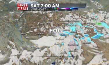
In the wake of our Friday storm, we’ll loo for some areas of overnight and morning fog for Saturday, with a slight chance of snow and rain to start…
Continue Reading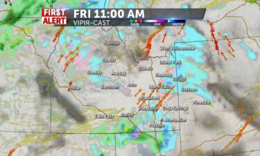
Good Morning! Slick conditions with cold rain/wintry mix/snow for higher elevations for the day today. Snow continues into Saturday morning.…
Continue Reading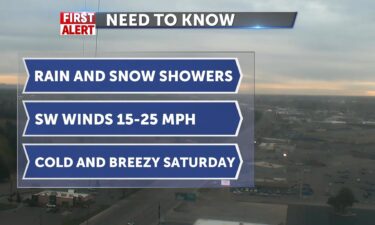
A storm system is moving through the region with scattered snow and rain showers. OVERNIGHT: Chance of snow and rain showers with low temperatures…
Continue Reading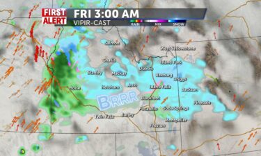
WIND CHILLS THIS MORNING START US OFF FEELING LIKE 10-15 DEGREES AND BELOW ZERO WITH MOUNTAIN TEMPERATURES. CLOUDS BUILDING AND HIGHS IN THE 38-41…
Continue Reading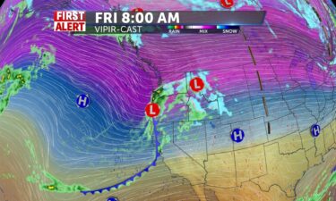
We have an approaching storm system moving in for Thursday evening into Friday and Saturday morning. This storm will usher in scattered snow and rain…
Continue Reading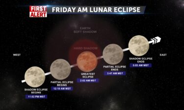
Cranking out lots of sunshine, thanks to the major clearout from yesterday’s cold front. We felt the front, with winds 40-60mph gusts, and today is…
Continue Reading
Our cold front is exiting to the east for tonight with gusty winds through the early evening. However, winds are expected to relax into the overnight…
Continue Reading
A cold front from the west will drive in gusty winds, a few snow and rain showers and colder temperatures. OVERNIGHT: Cloudy with gusty winds with…
Continue Reading
With a push of high pressure and warm air from a ridge south and west of us, we’ll hit 60+ degrees today. Winds ahead of and behind a frontal…
Continue Reading
Record high temperatures for November are possible for tomorrow. High temperatures will up to the low 60’s for the valleys and into the 50’s for the…
Continue Reading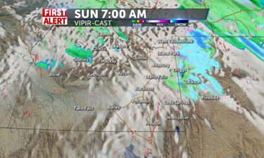
Clouds should clear up slightly into tomorrow for a partly cloudy day for everyone with only isolated showers for the mountains in the early morning…
Continue Reading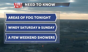
OVERNIGHT: Areas of fog a mostly cloudy skies, light winds and a slight chance of rain/snow. SATURDAY: Areas of morning fog with increasing winds for…
Continue Reading I can see you through the fog. it will be around all day, some freezing fog is possible. With a limited amount of showers across mountain areas, it…
Continue Reading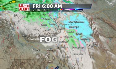
Cold overnight into Friday, with another disturbance on along the jet-stream, ushering in some moisture and wind for Saturday. Another storm system…
Continue Reading
Northwestern flow shoots snow/wintry mix into central mountains for a possible icy day, Mountain snows and the chance for a wintry mix take over the…
Continue Reading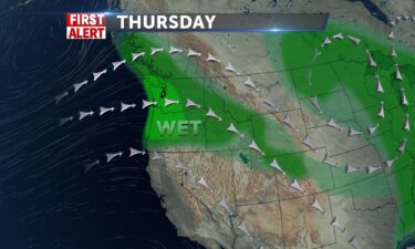
OVERNIGHT: Cloudy with lows into the upper 20’s with SW Winds 10-20 MPH, A few mountain snow showers. THURSDAY: Mostly cloudy with a chance of rain…
Continue Reading Wind Chills this morning with decreasing clouds will make for a brisk Wednesday, with some sun poking through eventually. It will be dry as…
Continue Reading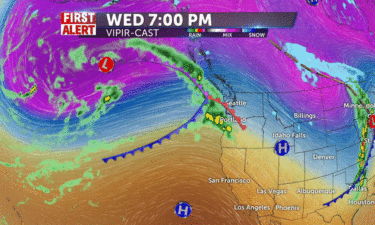
Scattered snow and rain showers for tonight with showers ending for most of us Wednesday. Overnight, look for mostly cloudy skies, a few snow and…
Continue Reading
We are starting with cold 20’s this morning as we track the storm which will shake you down today. Snow expected for mountains, Sun Valley,…
Continue Reading 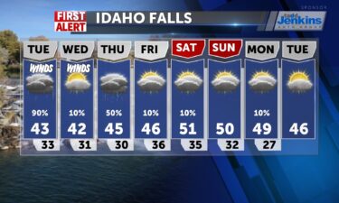
Stormy weather with some sub-tropical moisture will be with us late Monday into Tuesday. Snow levels are expected to stay above the Snake River…
Continue Reading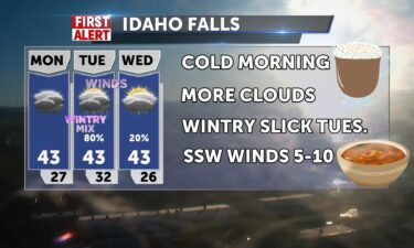
INCREASING CLOUDS AND COLD START TODAY WITH TEMPS IN THE MID 20’S. HIGHS TODAY WIL ONLY BE IN THE LOWER 40’S – 41-43 DEGREES. WINDS ARE…
Continue Reading
We will have only partly cloudy skies into the day for tomorrow with no rain or snow showers moving into the area. High temperatures go up into the…
Continue Reading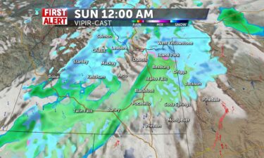
We will see lots of rain showers and snow showers making their way across our area tonight and into the overnight and early morning…
Continue Reading
We’ll continue seeing a parade of storms moving through the Pacific northwest. OVERNIGHT: Mostly cloudy with lows into the upper 30’s with winds…
Continue Reading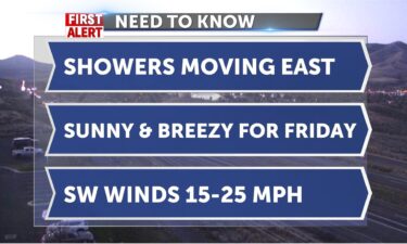
We start with chilly wind chills, temps are in the 40’s but feels colder with SW winds 15-25mph. Sunny today after the front last night has…
Continue Reading
OVERNIGHT: A chance of rain showers with partly to mostly cloudy skies. Lows around the upper 30’s for the Snake River Plain. Gusty winds overnight,…
Continue Reading
A weak storm system for us, moves through this Thursday. Overnight, look for partly to mostly cloudy skies, with a chance of fog. Overnight lows back…
Continue Reading
As our rainy weather clears out for Tuesday evening, we’ll see some patchy overnight and morning fog. Mostly cloudy overnight, with lows into the mid…
Continue Reading
Breezy SW 5-15mph chilly rain takes us into midday, after some wintry showers across the mountain areas. We’ve seen over a tenth of an inch of rain…
Continue Reading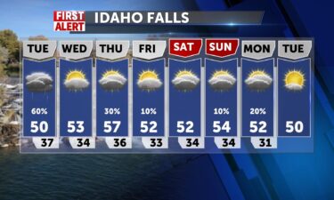
A quick moving system is dropping in rain and high elevation snow Monday night into Tuesday. OVERNIGHT: Cloudy with rain showers, Lows around 40°,…
Continue Reading
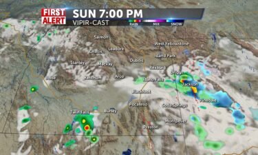
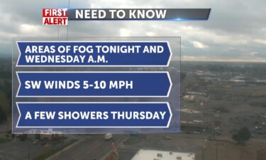
Isolated rain showers will line up the sky for trick or treating tonight from the Snake River Plains to Western…
Continue Reading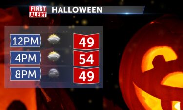
We will be dealing with some isolated rain showers into the evening hours for…
Continue Reading We have a cold front entering the region for Friday night into Saturday. We’ll see a few showers for this weekend, with a larger system moving in for…
Continue Reading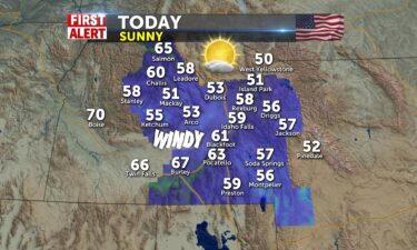
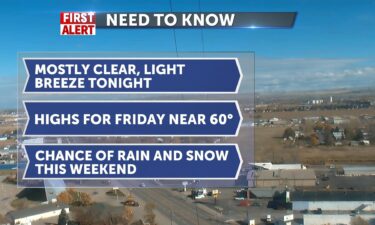
Highs close to 60° for Friday, chance of weekend showers A system is slowly moving in from the northwest. The front will pass through late Friday…
Continue Reading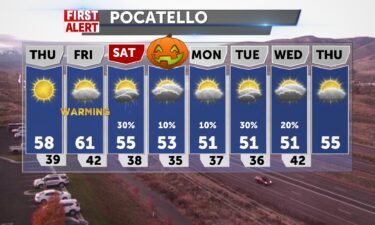
A system to our north will keep some wind in the forecast, with clearing skies into Thursday. Another cold front arrives late Friday, which will…
Continue Reading
We are expecting some slight snow showers in the mountain tops today with maybe some rain for the nearby towns in the valleys. This includes areas…
Continue Reading
Windy with a few isolated rain and snow showers Our exiting cold front will keep cold temps, gusty winds and scattered showers for this evening.…
Continue Reading
A cold front is moving through the area tonight through Tuesday. Look for more scattered rain and snow showers with lows tonight into the mid 30’s.…
Continue Reading
We have more rain and snow showers in store for tomorrow. They look to be continuing until the nighttime and late afternoon hours for most of…
Continue Reading
Heavy rain showers for the valleys and snow showers for the mountains should start…
Continue Reading
A series of showers will roll in from the Pacific this weekend and next week. This storm will start to drop in quite a bit of rain and snow late…
Continue Reading
FRIDAY: Mostly sunny, upper 60’s in the Snake River Plain. SW gusts above 20+ MPH SATURDAY: A chance of rain with mostly cloudy skies, mountain snow.…
Continue Reading
A weak ridge of high pressure is overhead for tonight and Friday, but this ridge will be quickly replaced with stormy weather. A parade of storms…
Continue Reading
Great Fall Weather for Thursday, stormy weather on the way A parade of Pacific moisture is working into the west. We’ll sit with some nice conditions…
Continue Reading

Sunny skies will be present with just a little bit of cloud cover. TOMORROW: Sunny skies will be present with just a little bit of cloud cover.…
Continue Reading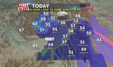
The morning begins with a backlash of moisture from the low that passed over us yesterday. Colder mountain temps change on the slop down in the…
Continue Reading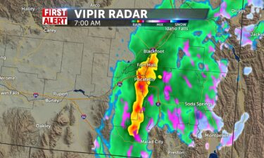
We have some light rain and snow showers beginning to show up on our radar that should last throughout the nighttime…
Continue Reading