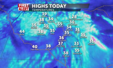
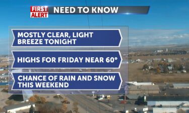
Clearing today for a sunny Thanksgiving
We will have some isolated snow showers present in SE Idaho all the way up to Pocatello and in western WY including the Tetons in the morning…
Continue Reading We will have some isolated snow showers present in SE Idaho all the way up to Pocatello and in western WY including the Tetons in the morning…
Continue Reading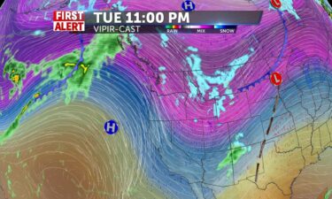
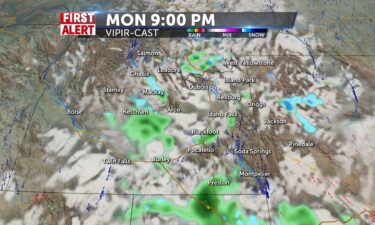
A cold front tonight, will usher in scattered snow, gusty winds and dropping temperatures. TONIGHT: A chance of snow with winds 20-30 MPH, gusts…
Continue Reading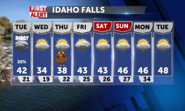
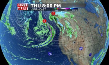
A cold front is on the move for Tuesday, with a few snow showers, gusty winds and dropping temperatures. OVERNIGHT: Mostly clear with lows into the…
Continue Reading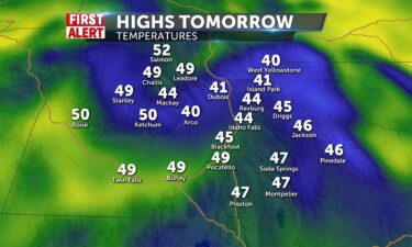
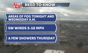
After some morning fog in the Upper Snake River Plain, we should all see mostly sunny skies throughout the day. We will look to slightly warm the…
Continue Reading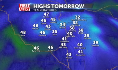
A calm day is in store for tomorrow with more cold conditions.…
Continue Reading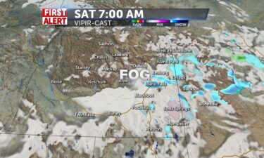
In the wake of our Friday storm, we’ll loo for some areas of overnight and morning fog for Saturday, with a slight chance of snow and rain to start…
Continue Reading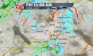
Good Morning! Slick conditions with cold rain/wintry mix/snow for higher elevations for the day today. Snow continues into Saturday morning.…
Continue Reading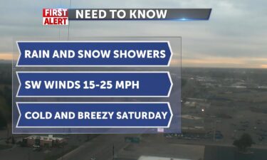
A storm system is moving through the region with scattered snow and rain showers. OVERNIGHT: Chance of snow and rain showers with low temperatures…
Continue Reading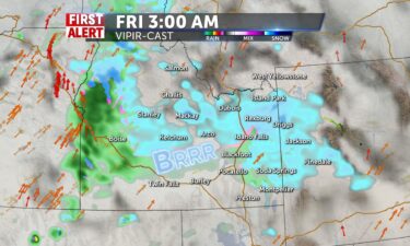
WIND CHILLS THIS MORNING START US OFF FEELING LIKE 10-15 DEGREES AND BELOW ZERO WITH MOUNTAIN TEMPERATURES. CLOUDS BUILDING AND HIGHS IN THE 38-41…
Continue Reading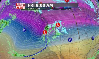
We have an approaching storm system moving in for Thursday evening into Friday and Saturday morning. This storm will usher in scattered snow and rain…
Continue Reading
Cranking out lots of sunshine, thanks to the major clearout from yesterday’s cold front. We felt the front, with winds 40-60mph gusts, and today is…
Continue Reading
Our cold front is exiting to the east for tonight with gusty winds through the early evening. However, winds are expected to relax into the overnight…
Continue Reading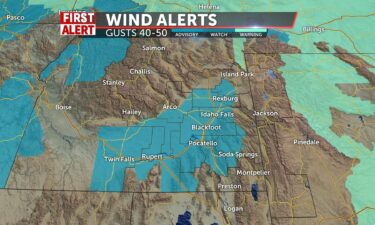
A cold front from the west will drive in gusty winds, a few snow and rain showers and colder temperatures. OVERNIGHT: Cloudy with gusty winds with…
Continue Reading
With a push of high pressure and warm air from a ridge south and west of us, we’ll hit 60+ degrees today. Winds ahead of and behind a frontal…
Continue Reading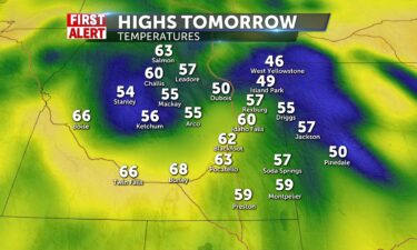
Record high temperatures for November are possible for tomorrow. High temperatures will up to the low 60’s for the valleys and into the 50’s for the…
Continue Reading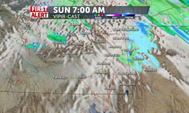
Clouds should clear up slightly into tomorrow for a partly cloudy day for everyone with only isolated showers for the mountains in the early morning…
Continue Reading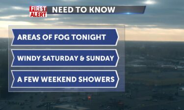
OVERNIGHT: Areas of fog a mostly cloudy skies, light winds and a slight chance of rain/snow. SATURDAY: Areas of morning fog with increasing winds for…
Continue Reading
I can see you through the fog. it will be around all day, some freezing fog is possible. With a limited amount of showers across mountain areas, it…
Continue Reading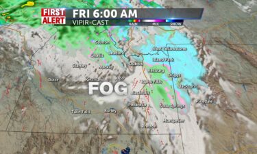
Cold overnight into Friday, with another disturbance on along the jet-stream, ushering in some moisture and wind for Saturday. Another storm system…
Continue Reading
Northwestern flow shoots snow/wintry mix into central mountains for a possible icy day, Mountain snows and the chance for a wintry mix take over the…
Continue Reading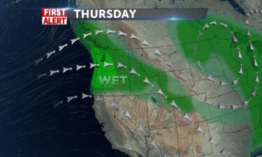
OVERNIGHT: Cloudy with lows into the upper 20’s with SW Winds 10-20 MPH, A few mountain snow showers. THURSDAY: Mostly cloudy with a chance of rain…
Continue Reading Wind Chills this morning with decreasing clouds will make for a brisk Wednesday, with some sun poking through eventually. It will be dry as…
Continue Reading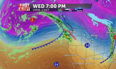
Scattered snow and rain showers for tonight with showers ending for most of us Wednesday. Overnight, look for mostly cloudy skies, a few snow and…
Continue Reading
We are starting with cold 20’s this morning as we track the storm which will shake you down today. Snow expected for mountains, Sun Valley,…
Continue Reading 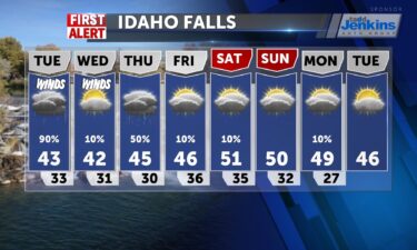
Stormy weather with some sub-tropical moisture will be with us late Monday into Tuesday. Snow levels are expected to stay above the Snake River…
Continue Reading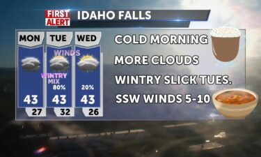
INCREASING CLOUDS AND COLD START TODAY WITH TEMPS IN THE MID 20’S. HIGHS TODAY WIL ONLY BE IN THE LOWER 40’S – 41-43 DEGREES. WINDS ARE…
Continue Reading
We will have only partly cloudy skies into the day for tomorrow with no rain or snow showers moving into the area. High temperatures go up into the…
Continue Reading
We will see lots of rain showers and snow showers making their way across our area tonight and into the overnight and early morning…
Continue Reading
We’ll continue seeing a parade of storms moving through the Pacific northwest. OVERNIGHT: Mostly cloudy with lows into the upper 30’s with winds…
Continue Reading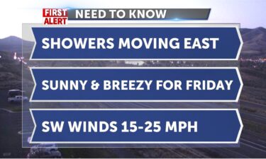
We start with chilly wind chills, temps are in the 40’s but feels colder with SW winds 15-25mph. Sunny today after the front last night has…
Continue Reading
OVERNIGHT: A chance of rain showers with partly to mostly cloudy skies. Lows around the upper 30’s for the Snake River Plain. Gusty winds overnight,…
Continue Reading
A weak storm system for us, moves through this Thursday. Overnight, look for partly to mostly cloudy skies, with a chance of fog. Overnight lows back…
Continue Reading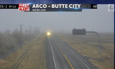
As our rainy weather clears out for Tuesday evening, we’ll see some patchy overnight and morning fog. Mostly cloudy overnight, with lows into the mid…
Continue Reading
Breezy SW 5-15mph chilly rain takes us into midday, after some wintry showers across the mountain areas. We’ve seen over a tenth of an inch of rain…
Continue Reading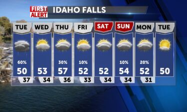
A quick moving system is dropping in rain and high elevation snow Monday night into Tuesday. OVERNIGHT: Cloudy with rain showers, Lows around 40°,…
Continue Reading
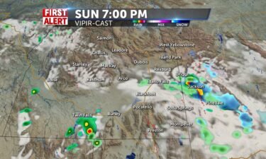
Isolated rain showers will line up the sky for trick or treating tonight from the Snake River Plains to Western…
Continue Reading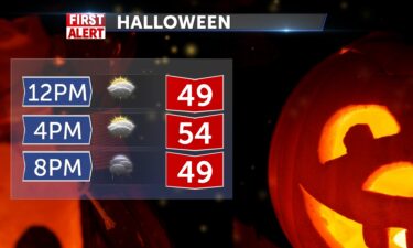
We will be dealing with some isolated rain showers into the evening hours for…
Continue Reading We have a cold front entering the region for Friday night into Saturday. We’ll see a few showers for this weekend, with a larger system moving in for…
Continue Reading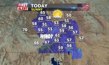
Highs close to 60° for Friday, chance of weekend showers A system is slowly moving in from the northwest. The front will pass through late Friday…
Continue Reading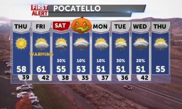
A system to our north will keep some wind in the forecast, with clearing skies into Thursday. Another cold front arrives late Friday, which will…
Continue Reading
We are expecting some slight snow showers in the mountain tops today with maybe some rain for the nearby towns in the valleys. This includes areas…
Continue Reading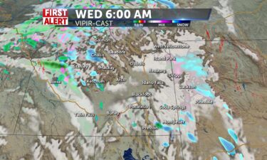
Windy with a few isolated rain and snow showers Our exiting cold front will keep cold temps, gusty winds and scattered showers for this evening.…
Continue Reading
A cold front is moving through the area tonight through Tuesday. Look for more scattered rain and snow showers with lows tonight into the mid 30’s.…
Continue Reading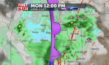
We have more rain and snow showers in store for tomorrow. They look to be continuing until the nighttime and late afternoon hours for most of…
Continue Reading
Heavy rain showers for the valleys and snow showers for the mountains should start…
Continue Reading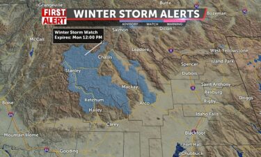
A series of showers will roll in from the Pacific this weekend and next week. This storm will start to drop in quite a bit of rain and snow late…
Continue Reading
FRIDAY: Mostly sunny, upper 60’s in the Snake River Plain. SW gusts above 20+ MPH SATURDAY: A chance of rain with mostly cloudy skies, mountain snow.…
Continue Reading
A weak ridge of high pressure is overhead for tonight and Friday, but this ridge will be quickly replaced with stormy weather. A parade of storms…
Continue Reading
Great Fall Weather for Thursday, stormy weather on the way A parade of Pacific moisture is working into the west. We’ll sit with some nice conditions…
Continue Reading

Sunny skies will be present with just a little bit of cloud cover. TOMORROW: Sunny skies will be present with just a little bit of cloud cover.…
Continue Reading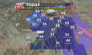
The morning begins with a backlash of moisture from the low that passed over us yesterday. Colder mountain temps change on the slop down in the…
Continue Reading
We have some light rain and snow showers beginning to show up on our radar that should last throughout the nighttime…
Continue Reading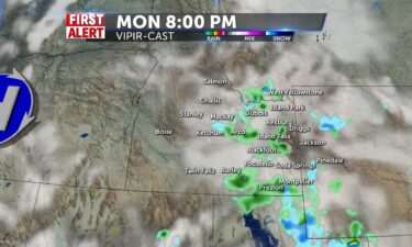

Rain and snow showers will be increasing in number as we continue into the afternoon. They should start in the afternoon hours and the peak of the…
Continue Reading
It’s gonna be another sunshine filled day for the rest of the weekend. High temperatures will get another lift to warmer conditions in the 60’s with…
Continue Reading
High pressure to our south will push in highs into the 50’s with mostly sunny skies. We’ll see our next chance of wet weather will arrive Sunday…
Continue Reading
Calm, dry, chilly and sunny conditions for the next few days in the region. We begin with some sparse mountain cloudiness, but mainly clear for us…
Continue Reading
We have a few snow showers with us tonight, as a weak system moves further to the east. High pressure works back into the region with warming temps.…
Continue Reading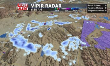
Morning begins with light snow across the valley, little to no accumulation expected. Highs today reach back toward 40, upper 30’s to the north, mid…
Continue Reading
A system is moving the the region overnight, delivering a chance of snow showers. This will not be as intense as Monday night’s storm, we’re looking…
Continue Reading
Morning cloudiness increases with not much change in temperatures today. Highs around 38-40. Winds will take wind chills into the teens for the…
Continue Reading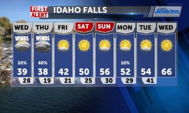
With our exiting system, we’ll see a few leftover snow showers and breezy winds Tuesday evening. Wednesday, we’ll look for a little sun to peak out…
Continue Reading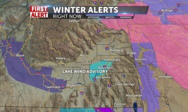
The threat of moderate to heavy snow has ended in the Snake River Plain and Upper highlands, so we remove the storm warning after a good 10 hours of…
Continue Reading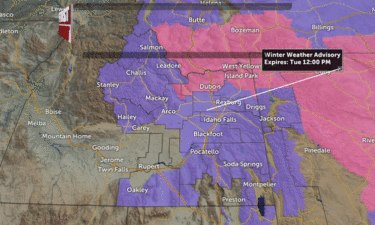
OVERNIGHT: Scattered rain and snow showers with lows into the upper 20’s to the lower 30’s for the Snake River Plain. Winds 10-20 MPH, new snow…
Continue Reading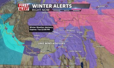
We’ll see snow/rain mix continue this afternoon with winds picking up at times NNW eventually, 15-20mph with gusts to 35. Lake Wind Advisory in…
Continue Reading
We will see mixed precipitation for everyone for much of the day. The chances of seeing snow will be much greater in the mountains and the chances of…
Continue Reading
We will have the sun come out for the majority of the day providing us with a slight break from the precipitation from the past couple of days.…
Continue Reading
Showers, thunderstorms and wind for tonight with dropping temps into next week An area of low pressure continues it’s trip through the west with…
Continue Reading
Scattered showers and storms today and building tonight and through tomorrow, we can expect llow 60’s and gusty winds with thunderstorms treking in…
Continue Reading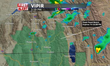
A deep area of low pressure is moving through the region this evening into Friday. We’ll see dropping temperatures into Friday with more rain and…
Continue Reading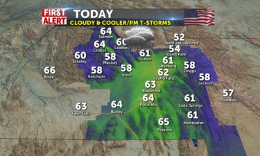
Scattered showers and storms today and building tonight and through tomorrow, we can expect lower temperatures today and gusty winds with…
Continue Reading 
Expect a stormy weather pattern through Saturday morning. We’ll see off and on showers with thunderstorms and mountain snow. OVERNIGHT: A chance of…
Continue Reading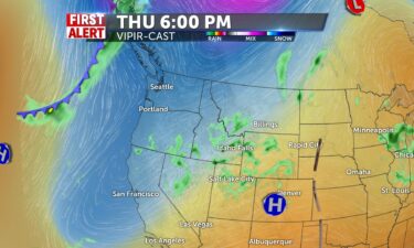
An area of low pressure is advancing into the west off the Pacific. Ahead of that low, we’re also seeing moisture out of the south with a few storm…
Continue Reading
Moisture makes it way into our area tonight and early tomorrow morning with the risk for a heavy shower/storm. Today will be warm ahead of a front…
Continue Reading
Wet weather is approaching from the south and the west this week. For Tuesday, we’ll see increasing cloud cover, warm temps before the stormy…
Continue Reading 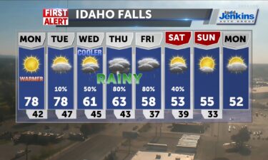
Mostly sunny skies will be ahead for tomorrow bringing more sunshine. High temperatures will get up to above 80 degrees even in some areas, but most…
Continue Reading
We are warming up tomorrow slightly with high’s looking to get into the low 70’s. This will be present with continuous sunshine through the day.…
Continue Reading
We have a weak front moving through the region for central Idaho and the Snake highlands, with a few isolated showers. Temperatures will rise…
Continue Reading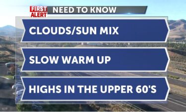
A weak front comes by today keeping temps in the upper 60’s with increasing cloudiness into midday. 67 in Idaho Falls, 71 in Salmon, 69 in Pocatello.…
Continue Reading
A weak system will move through the region this Friday, we’ll see just a few mountain rain showers, with cloud cover for the rest of us. TONIGHT:…
Continue Reading
Pleasant today with a dome of high pressure keeping us dry with lots of sunshine. The freezing lows will ease out of the picture and we’ll have highs…
Continue Reading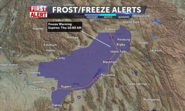
Freezing overnight lows Wednesday night, Thursday night and Friday night. We’ll see light winds in the forecast with a mainly clear sky. High…
Continue Reading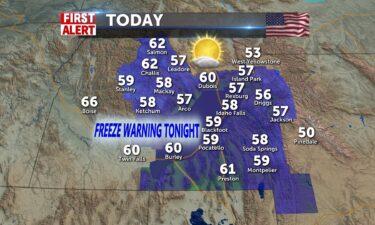
Feeling the chill today. Sunny, calm winds, in the upper 50’s. FREEZE WARNING again tonight for Snake River Plain-Lows 29-32 degrees. I’ll tell you…
Continue Reading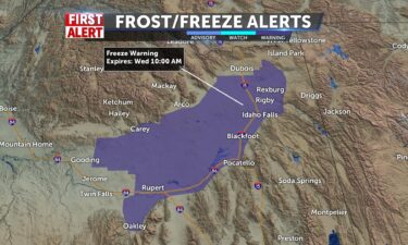
Breezy tonight with winds slowly decreasing overnight into Wednesday. Colder temps tonight with a Freeze Warning for early Wednesday morning. We’re…
Continue Reading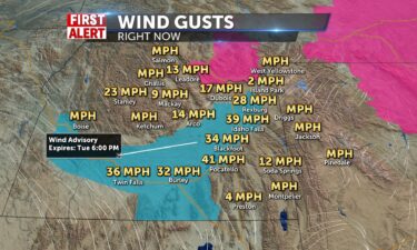
Cold front arriving this morning will pick up our winds at 25-35 mph (50mph gusts). Wind Advisory through 6pm for the valley and into Magic Valley.…
Continue Reading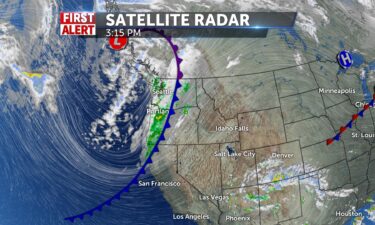
A quick moving cold front will drive in winds and scattered showers for Tuesday. This system clears by Wednesday. TONIGHT: Areas of smoke and haze…
Continue Reading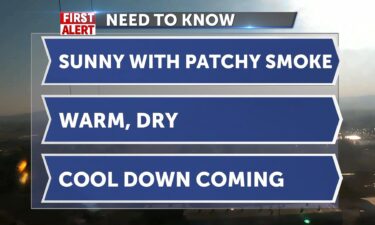
We get one more day of warm, dry sunshine with a breezy afternoon. Highs today with some patchy smoke will hover around 82. A cold front will cut…
Continue Reading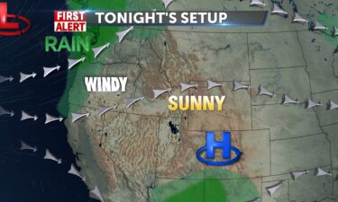
We are expecting another beautiful warm day to start off the work week. Sunny skies will be present throughout the entire day. A cold front will…
Continue Reading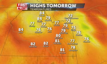
We got another picture perfect day in store for tomorrow. Sunny skies will be present throughout the entirety of the day which will also thus pose no…
Continue Reading