
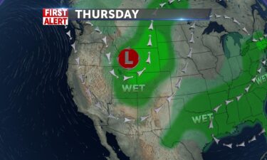
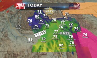
Warmer and breezy for this weekend
Highs will be close to 80° this weekend, with a weak wave moving through North Idaho and Montana. This wave, will bring in some wind for Saturday…
Continue Reading Highs will be close to 80° this weekend, with a weak wave moving through North Idaho and Montana. This wave, will bring in some wind for Saturday…
Continue Reading
OVERNIGHT: Mostly clear with a few isolated showers in northern Utah and Western Wyoming. Lows into the lower 40’s NW winds 5-10 MPH. FRIDAY: Sunny…
Continue Reading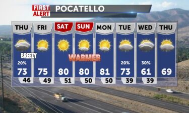
After highs in the upper 70’s yesterday and 80 in Pocatello, a weak cold front brings sparse clouds and light isolated showers then makes way for…
Continue Reading
Chance of showers Wednesday night and Thursday morning A quick moving cold front will sweep in Wednesday night with some wind and isolated showers.…
Continue Reading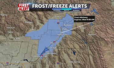
High pressure will keep us dry for Tuesday night and Wednesday morning. A quick moving cold front Wednesday night, will drive in gusty winds and a…
Continue Reading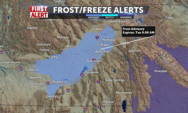
Frost Advisory Tuesday Morning Freezing temperatures tonight with lows into the lower 30’s and areas of fog. High pressure will build back in for…
Continue Reading
Brisk cold front pushes chilly rain through Sunday and lodges some cold air on Idaho for this morning and today. Frost Advisory is in effect for the…
Continue Reading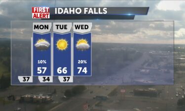
We will look to have the same high temperatures tomorrow just without many chances for rain. High temperatures will be in the upper 50’s with calm…
Continue Reading
A massive cooldown starts tomorrow. High temperatures only look to get up to the 50’s. It will be rainy for most of the day for us starting in the…
Continue Reading
A cold front is approaching for this weekend. Before the cold front arrives Sunday, we’ll see gusty winds and warmer temps for Saturday, along with a…
Continue Reading
With Fall approaching next week, it will feel much cooler as the days get shorter. Some blustery winds will accompany sunny conditions today and…
Continue Reading
Windy weather as one front leaves the region, with another cold front arriving this weekend. Tonight: Staying breezy with lows around 40° for Idaho…
Continue Reading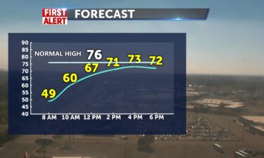
A cold front to the north and high pressure to the east, will usher in slightly cooler temps for Thursday. We’ll also see winds for the next couple…
Continue Reading
A dry front from the north will draw up warmer air from the south for Wednesday. Highs for Wednesday will get into the lower 80’s for the Snake River…
Continue Reading
Tonight, look for a few isolated thunderstorms with lows back into the 30’s to 40’s. Tuesday will be nice and quiet with highs into the mid to lower…
Continue Reading
Sunny and dry with SW winds 5-15 mph and gusts to 20+. High pressure is over the region and that means consistent happy sunny weather for about 5…
Continue Reading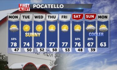
Sunny skies are ahead with a little bit of smoke for the next few days. A dry spell completely knocks out any rain chances for Tuesday and it should…
Continue Reading
More widespread haze will continue to fill our area throughout the area for tomorrow. More isolated showers will be in the picture tomorrow in the…
Continue Reading
An area of low pressure with a cold front is moving through the region. We’ll see scattered thunderstorms tonight and Saturday with partly to mostly…
Continue Reading
Winds are increasing and the threats for thunderstorms will pick up for Friday, as a system from the northwest arrives. We’ll keep it hazy tonight…
Continue Reading
The smoke is widespread and will cover the area into the afternoon. High pressure remains dominant for us and keeps abundant sunshine coming taking…
Continue Reading
We’re holding onto the heat for another day, with highs into the 90’s. We’ll also see the winds pick for for Thursday after we slowly lose our high…
Continue Reading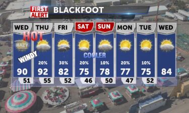
The smoke is widespread and will cover the area into the afternoon. High pressure remains dominant for us and keeps abundant sunshine coming taking…
Continue Reading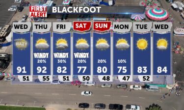
Tonight: Smoke with partly cloudy skies. Lows into the lower 50’s with light winds. Wednesday: Smoke and hazy skies with highs into the lower 90’s.…
Continue Reading
High pressure keeps us dry and warm today with highs in the 80’s. Light breezes today SW 5-10 and 88 in Pocatello, 85 in Idaho Falls and low 80’s for…
Continue Reading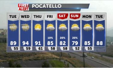
Winds will start to calm into Tuesday, with an exiting dry front to our north. High pressure to the south, will continue to build in with warming…
Continue Reading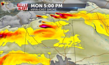
RED FLAG WARNING IN EFFECT FROM NOON TODAY TO 9 PM MDT THIS EVENING FOR GUSTY WINDS AND LOW HUMIDITY FOR IDAHO FIRE WEATHER Widespread…
Continue Reading
Hazy and hot is the picture for much of the week…
Continue Reading
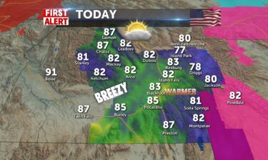
We are getting back toward much hotter conditions. The high temperatures tomorrow will be in the mid 80’s tomorrow with bright…
Continue Reading
High pressure to our south will start to warm us back up into the 80’s, by this Sunday and Monday. A system to the north, will drive in gusty winds…
Continue Reading
Winds will be brisk at times SW 10-15 (20+G) as another trough moves through the area to start Friday and give us some fall like temperatures. Sunny…
Continue Reading
Fairly quiet weather for tonight and Friday with cooler temps for Friday. High pressure over the weekend, will warm us back up into the 80’s. Smoke…
Continue Reading
Breezy Wednesday evening with an exiting area of low pressure to our north. Lows tonight will bottom out into the mid to upper 40’s, with areas of…
Continue Reading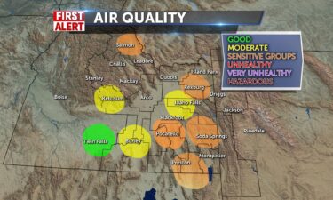
Widespread haze with sunshine and winds NNW 5-15 with gusts beyond 20mph today.Air quality may be of concern for those sensitive. Highs for most…
Continue Reading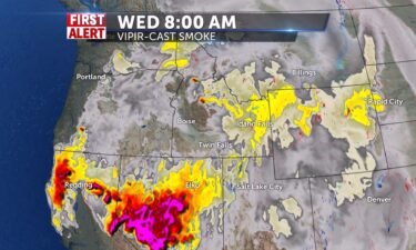
A system to the north is driving in winds for Tuesday evening, with slightly cooler temps for Wednesday. OVERNIGHT: Lows into the lower 50’s, with…
Continue Reading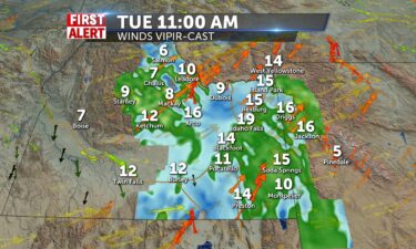
Not a great day to be outdoors for the region. Southwestern winds pull more smoke in from fires to the west and then with low humidity and gusts…
Continue Reading
A system will be working in from the northwest. Look for breezy conditions and more smoke drifting through the region. A thunderstorm threat arrives…
Continue Reading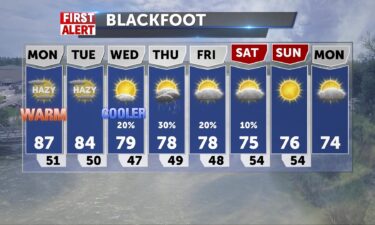
Dry, mostly sunny with widespread haze and warm today. More smoke coverage this afternoon and tonight with gusty winds from a southwesterly flow…
Continue Reading
A few thunderstorms this evening near Island Park, Yellowstone NP and the Wyoming state line. As an area of low pressure exits the region, we’ll see…
Continue Reading
Windy afternoon, helping to clear smoke. Lake Wind Advisory through tonight for American Falls Reservoir and lower Snake River Plain. Highs in the…
Continue Reading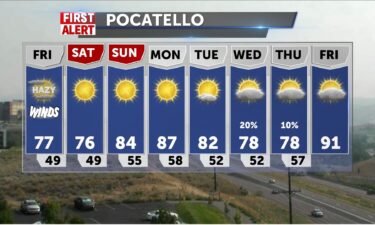
An area of low pressure is moving through north Idaho and Montana. This low will usher in winds and slightly cooler temps for Friday. Temps will also…
Continue Reading
Dry conditions, some clouds and smoky haze over the area are a part of the pattern for today with cooler weather coming. The preview of September…
Continue Reading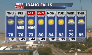
With a southwest flow we’ll look for more smoke and haze to hang over the region, with even more smoke arriving for Thursday. For Thursday, expect…
Continue Reading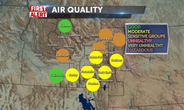
Hazy skies continue to stick around with us through tonight. This does bring along more air quality concerns with most of the region being either…
Continue Reading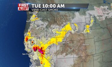
Hazy skies will blanket our area for much of the night. We will have air quality concerns with some areas becoming unhealthy for sensitive…
Continue Reading
Hazy skies will blanket our area for much of the day. Concerns are already building over air quality getting unhealthy for sensitive…
Continue Reading
The haze is going to be continuously rolling back in through the night…
Continue Reading
We are currently seeing thunderstorms within most of eastern ID and western WY. More of them are concentrated in southeast ID with a line of heavy…
Continue Reading
A few isolated showers and thunderstorms for Friday evening with partly cloudy skies. Lows overnight into the upper 40’s. Saturday, another area of…
Continue Reading
A drier northwest flow arrives for Friday, with a few isolated thunderstorms possible Friday afternoon. Smoke will also try to seep in from the west,…
Continue Reading
We have an area of low pressure over Idaho, with scattered showers, thunderstorms and cooler temps for tonight and Thursday. This low will move off…
Continue Reading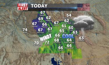
A continuous track of showers and some thunderstorms over eastern Idaho and a heavier presence of smoke continues. With almost constant showers over…
Continue Reading
We move some of this smoke tonight with a cold front slowly moving through. We’ll see scattered thunderstorms and gusty winds tonight. The scattered…
Continue Reading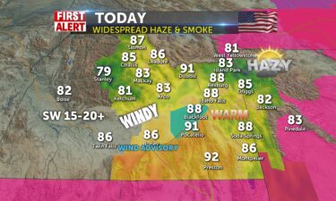
Smoke remains in the forecast with warm conditions today. An approaching cold front will give us some brief relief with some fast showers and…
Continue Reading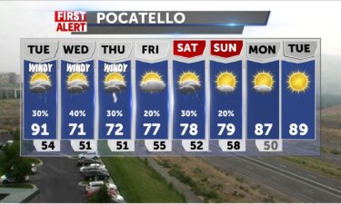
A few isolated showers and thunderstorms tonight, more scattered showers as our ridge of high pressure to the south is beginning to break down. We’ll…
Continue Reading
AN AIR POLLUTION FORECAST AND CAUTION HAS BEEN ISSUED BY THE IDAHO DEPARTMENT OF ENVIRONMENTAL QUALITY… Due to wildfire smoke, the air quality has…
Continue Reading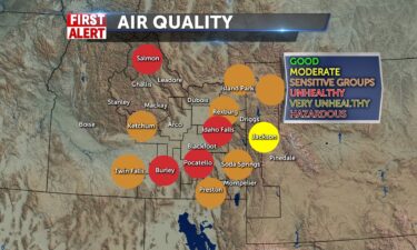
We have many areas currently under unhealthy air quality conditions including the Salmon/Challis National Forest and the Snake River Plain from Idaho…
Continue Reading
More and more smoke continues to roll into the area from slight breezes of winds coming from the west. We should see mostly sunny skies with another…
Continue Reading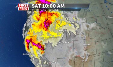
More haze and smoke will continue to keep coming on in for the beginning of the weekend leading to some possible concerns in air quality. Hot…
Continue Reading
Conditions remain pretty calm throughout the area tonight. Mostly clear skies are expected throughout the night with no rain chances. Temperatures…
Continue Reading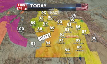

The Idaho Department of Environmental Quality (DEQ) has lifted an Air Pollution Forecast and Caution to notify residents of Bonneville, Teton,…
Continue Reading
We have much cooler temperatures in store for tomorrow with high’s only getting into the mid 70’s. The smoke will look to be considerably decreased…
Continue Reading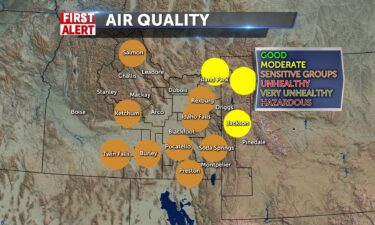
The hazy skies continue throughout the night tonight. Air quality due to this smoke is sensitive to unhealthy groups so do take…
Continue Reading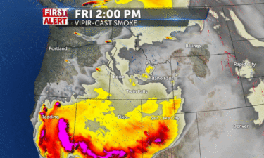
We’re slowly losing the wet weather late Friday into this weekend, with drier and warmer weather for Saturday. We’ll continue to see smoke and haze…
Continue Reading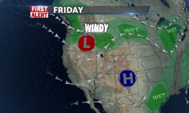
An area of low pressure will slide in from the west coast tonight and Friday. We’ll see highs fall into the 70’s and lower 80’s for Friday with the…
Continue Reading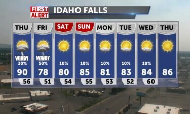
An area of low pressure will push in from the northwest for the end of the workweek and this weekend. We’ll still have smoke with us for Thursday,…
Continue Reading
We’ve come out from under monsoonal flow and it will be hot and sunny today, however, we’ll have a smoky haze over the eastern Idaho and western…
Continue Reading High pressure to the south will keep us mostly dry through Wednesday and Thursday with a slight chance of thunderstorms. A cold…
Continue Reading
A return to calmer weather today with widespread haze for later and highs in the mid to upper 80’s for Tuesday. A gradual warm up into Wednesday as…
Continue Reading
Scattered thunderstorms Monday night, drier weather with smoke for Tuesday Scattered thunderstorms with a flood advisory through Monday evening.…
Continue Reading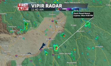
We’ve still got a lot of moisture over us and the risk of storms for the day continues, with a flash flood watch in effect for today and tonight for…
Continue Reading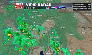
Lots of rain showers and thunderstorms around are capable of producing 1 to 2 inches of rainfall in a short amount of…
Continue Reading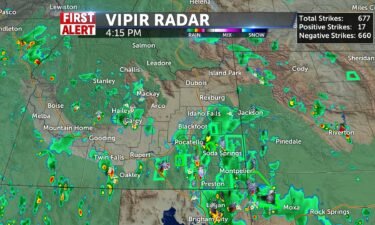
Thunderstorms and lots of lightning should continue into the nighttime…
Continue Reading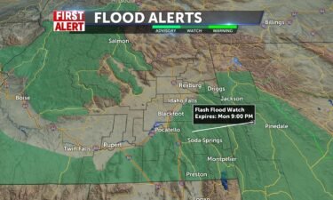
Look for more of the same, with slightly cooler temps into the 80’s and isolated to scattered thunderstorms. Friday night: A chance of thunderstorms…
Continue Reading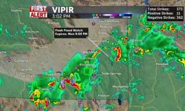
Scattered showers and thunderstorms will continue for Friday evening with some slow moving storms leading to a possible flash flood.FLASH FLOOD WATCH…
Continue Reading Monsoonal moisture in place over the region will help fuel scattered showers and thunderstorms through Monday. Saturation and flooding chances exist…
Continue Reading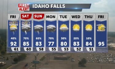
Scattered thunderstorms this evening and through tonight into Friday. We’ll also have gusty winds from these passing thunderstorms at 15-25 MPH, with…
Continue Reading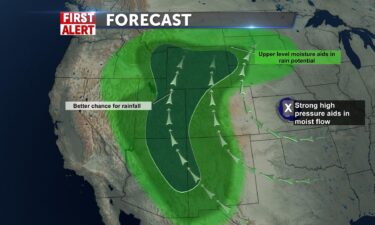
Tonight, look for a chance of thunderstorms with gusty winds. Lows into the mid 60’s, winds 10-20 MPH, with gusts around 30 MPH. Thursday,…
Continue Reading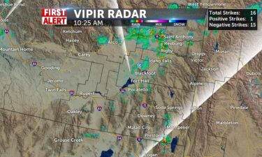

Highs into the upper 80’s and lower 90’s, with scattered thunderstorms. Overnight: Chance of showers and thunderstorms with lows into the upper 50’s,…
Continue Reading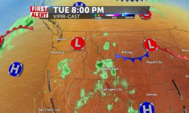
Smoke and haze to start Tuesday and moisture begins a push from the south. By the latter part of the day, storms may develop with gusty winds…
Continue Reading
Heat will subside a little bit for Tuesday as moisture arrives from the south. Look for scattered thunderstorms with highs into the lower 90’s and…
Continue Reading
Heat Advisory today for Snake River Plain and into the Magic Valley. Highs from 95-98 with areas of smoke today. @JeffRoper has the 8 day forecast…
Continue Reading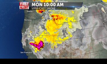
The hazy skies will continue into…
Continue Reading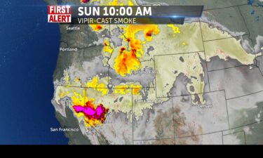
The smoke continues to roll into tomorrow from the fires in Central/northern Idaho and from Oregon and…
Continue Reading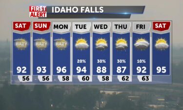
Overnight: Areas of smoke with lows around 60°, SW winds 15-25 MPH, with a thunderstorm risk for southeast Idaho and southwestern Wyoming. Saturday:…
Continue Reading
Areas of smoke today with highs in the low 90’s. Upper 80’s for Jackson. Fire Weather Warning in effect for Salmon and Challis and central mountain…
Continue Reading
We’re starting to flatten out the ridge of high pressure over the four corners, this will push back back on some of the monsoonal moisture. We’ll…
Continue Reading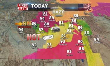
Mostly cloudy, breezes from southwest later 15-25mph, and some showers around to start Friday Eve. Some smoke and haze progressing toward east Idaho…
Continue Reading
Scattered thunderstorms for Wednesday night and again for Thursday. Overnight: A chance of thunderstorms with lows into the 60’s, along with some…
Continue Reading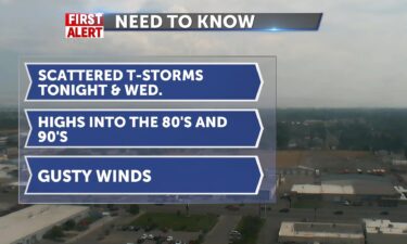
The monsoonal flow from the south continues around a ridge of high pressure. Tonight: Chance of showers and thunderstorms with lows into the 60’s…
Continue Reading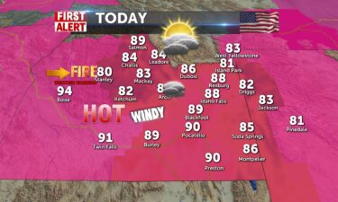
Moisture and heat today may pop a thundershower in our area, especially in the central regions. Winds will be pushing in from the southwest…
Continue Reading Increased moisture from the south will up the thunderstorm risk. We’ll look for daytime highs down slightly with the cloud cover and thunderstorm…
Continue Reading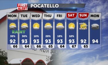
TONIGHT: Sprinkles of light rain are currently on the radar in the southern highlands and Central Idaho mountains. These storms in general are moving…
Continue Reading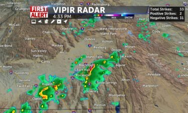
TONIGHT: Currently, we have severe thunderstorms in the southern highlands by Burley, McCammon, and even up to Pocatello and Blackfoot. These storms…
Continue Reading