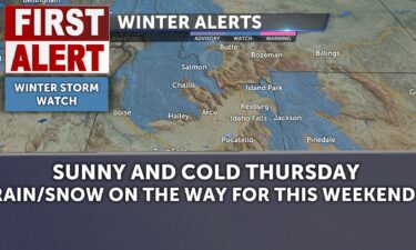
Mostly sunny for Thursday; snow and rain on the way
Mostly sunny and cold for Thursday. We see some major changes to the forecast starting late Friday.…
Continue Reading Mostly sunny and cold for Thursday. We see some major changes to the forecast starting late Friday.…
Continue Reading
Mostly sunny with some areas of low clouds this morning. Still cold as wid chills plunge below zero readings this morning and light winds this…
Continue Reading More of the same for Wednesday. Changes are on the way for this weekend with an atmospheric river scenario…
Continue Reading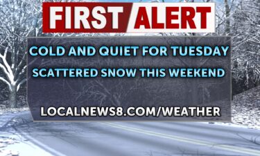
We’re still cold to begin Tuesday and lows below zero. The sun will be bright, so grab sunglasses and dress for cold and chilly wind chills (-4…
Continue Reading High pressure with valley inversions will stick around for much of this week. We’ll see this pattern change just in time for the weekend. Overnight…
Continue Reading
The Upper Snake River Plain and Mud Lake Desert/Arco/INL areas will have dangerously cold morning wind chills at or near -25 below. Exposed skin at…
Continue Reading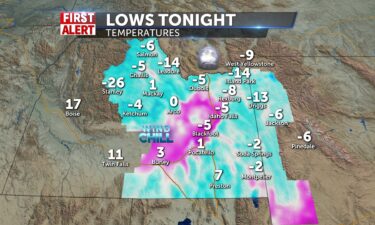
A chilly but sunny week ahead, at least until around Friday. Overnight tonight will be downright cold with temperatures in the single digits and…
Continue Reading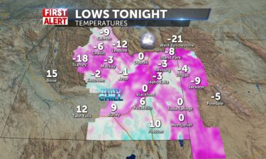
A cold start to Sunday. Overnight lows in the single digits and below zero, plus just enough of a breeze means wind chills will dip into the minus…
Continue Reading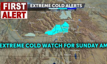
Chilly again this weekend with sunshine. An extreme cold watch has been issued for Sunday…
Continue Reading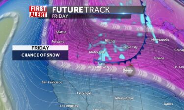
It’s warming and storming this morning, with snow in the eastern highlands and mountain passes. Snow is possible in the valley…
Continue Reading We’ll see slightly warmer temperatures overnight and into Friday, with cloud cover and snow working through the region. Overnight, mostly cloudy…
Continue Reading
We have a quick system breezing by here tomorrow bringing a chance of showers mainly to highland and mountain areas. Jackson has a 70% of snow…
Continue Reading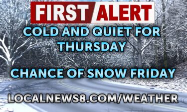
A slight chance of mountain snow tonigh with light winds. Cold and clear for the Plain. We’ll look for some scattered snow by Friday morning.…
Continue Reading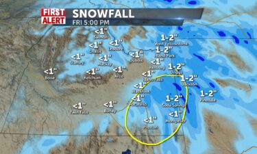
We’ve got wind chills below zero and some more freezing temps for the next couple of days. A snow chance into the Jackson area, around 30%. Sunshine…
Continue Reading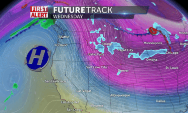
We’ve got wind chills below zero and some more freezing temps for the next couple of days. A snow chance into the Jackson area, around 30%. Sunshine…
Continue Reading Partly sunny for Wednesday, with highs around 18°. A chance of snow the higher elevations near the Wyoming state…
Continue Reading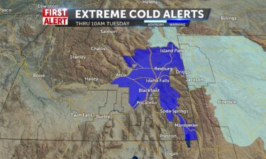
Extreme cold warning to start Tuesday. Highs will get back to the mid-teens for IF and mid 20’s for Pocatello. Wind chills still make it feel below…
Continue Reading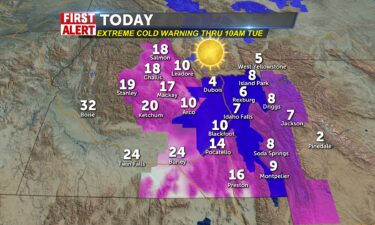
We continue under an extreme cold warning for a majority of our metro areas this morning, with wind chills already at -25 below for upper snake…
Continue Reading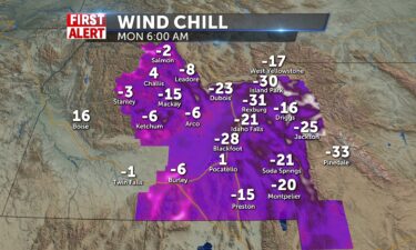
The extra cold air is here! Tonight/Monday morning. Cold weather advisories and warnings. Overnight lows below zero in the minus single digits…
Continue Reading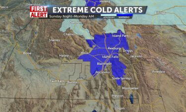
Our chilly weather is about be downright frigid as arctic air moves in from the north bringing us the coldest temperatures and wind chills we’ve seen…
Continue Reading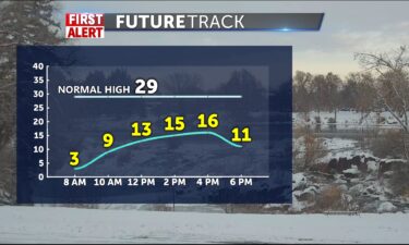
For Saturday, it will be partly cloudy with a few pockets of light snow. A high temperature around…
Continue Reading We’ve got a cold front sliding through our backyard to the east, bringing a good chance of showers to Wyoming and to the southeastern corner of the…
Continue Reading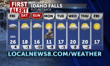
A slight chance of snow Friday with a cold blast of air this weekend and next…
Continue Reading
Before we get into arctic air this weekend, slightly warmer and seasonal today. Highs around 29-32. Cold front swings by the gem state and we’ll have…
Continue Reading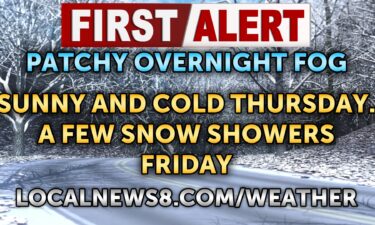
For Wednesday night and into Thursday, look for some patchy freezing fog. A low temperature around 12° in the Snake River Plain. Some areas of…
Continue Reading We are set up for another day with temps below freezing, some flurries around and patchy freezing fog into the morning in spots. Highs will gradually…
Continue Reading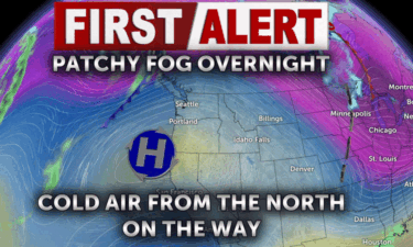
1/14/2025 Patchy freezing fog in the forecast for early Wednesday. A few areas of snow for Friday.…
Continue Reading
I’m tracking even colder air from the north in is coming in this weekend with lows expected below zero Saturday night and sunday A couple degrees…
Continue Reading Overnight, we’ll see areas of patchy fog, mostly cloudy skies in the Snake River Plain. A low of 15° with light winds. There is a slight chance of…
Continue Reading
I’m tracking even colder air from the north in the next 14 days. Monday starts with some patchy fog and a possible flurry or shower into the eastern…
Continue Reading
After a few gray days with snow showers, we’ll see the forecast quiet down for a bit. Over the next few days, high pressure will take control.…
Continue Reading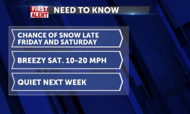
A cold front is moving through the region Friday night. Expect gusty winds through Saturday with scattered…
Continue Reading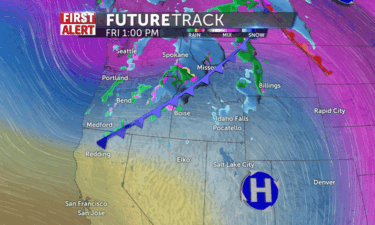
Our gray skies continue for a bit longer, but those clouds will actually do something tonight and tomorrow as we have a chance for snow showers. Snow…
Continue Reading Overnight, patchy dense freezing fog after 11pm. Mostly cloudy, with a low around 10. Light winds around 5mph.
For Friday, there will be some patchy…
Continue Reading We start Thursday with more cold air and patchy freezing fog for the Snake River Plain and the upper Snake Valley. In the wake of a passing front…
Continue Reading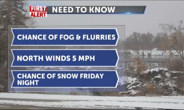
Overnight there is a chance of fog and low cloud cover. A slight chance of snow with a low temperature around 8° for Idaho Falls. A low around 13°…
Continue Reading
We begin Wednesday on a colder note than yesterday, thanks to high pressure opening the door for more cold arctic air and no insulation -patchy dense…
Continue Reading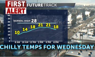
We’re keeping cold temperatures in the forecast with some valley fog re-developing overnight. For Wednesday evening, there is a disturbance out of…
Continue Reading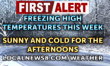
High pressure zooms in to dry things up and we see the sun again today. There patchy perhaps very dense freezing fog for th commute and that will…
Continue Reading We’ll see a few leftover snow showers for Monday night and Tuesday. High pressure will build in along the west coast, but this will help in more…
Continue Reading We’ve got a few eastern and southern showers on radar and light snow will make things slick to start back to school. Highs today around freezing with…
Continue Reading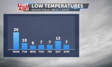
After a snowy and sometimes windy weekend, we have one more unsettled day before we get clearer and chillier thanks to high pressure building in.…
Continue Reading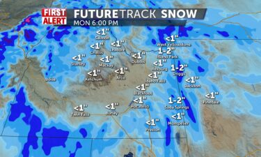
After a snowy and windy Saturday, we have a few more unsettled days before we get clearer and chillier thanks to high pressure building in. Sunday…
Continue Reading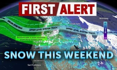
A cold front arrives early Saturday, with scattered snow and gusty winds. We’ll see scattered snow for Saturday morning and midday. A steady…
Continue Reading
Rain will freeze on your roads and windshield and sidewalks this morning. Highs will melt things down to the 38th degree ( warmer than usual ) ahead…
Continue Reading
Overnight, a chance of rain and snow with cloudy skies. A low temperature in the lower 30’s. Winds from the northwest wind around 5 mph becoming…
Continue Reading Flakes from low clouds and fog and dreary for today. Highs today in the mid 30’s to near 40 or so for Pocatello and the bottom of the banana belt.…
Continue Reading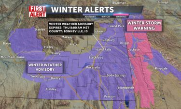
We’ll see some lightly scattered snow late Wednesday as this storm slowly exits overnight. There will be some leftover snow showers and flurries…
Continue Reading
WINTER WEATHER MESSAGENational Weather Service Pocatello ID222 PM MST Tue Dec 31 2024 WINTER WEATHER ADVISORY IN EFFECT FROM 7 AM WEDNESDAY TO 5…
Continue Reading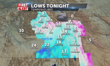
It will be cold for a few days in our region but eventually as more storms move in, we moderate out somewhat with our temperatures. Starting…
Continue Reading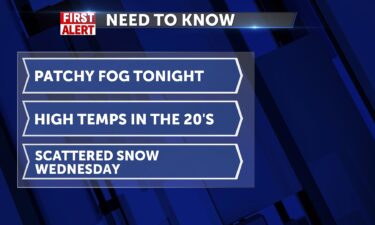
12/30/24: For Monday night and early Tuesday, we’ll see patchy freezing fog. A few flurries for Tuesday, with more snow Wednesday.…
Continue Reading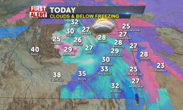
Winter storm warnings continue to 3pm for our eastern hills and mountains and western Wyoming. Avalanche warning through 6am Tuesday for the Bear…
Continue Reading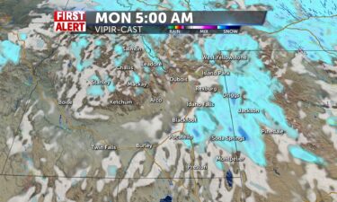
After several days of rain, snow, and wind, we will finally catch a bit of a break here in eastern Idaho and western Wyoming. Expect a more snow…
Continue Reading
It’s been a gray, unsettled day and we’re sticking with this pattern for a little bit longer. Several waves of snow with some rain for lower…
Continue Reading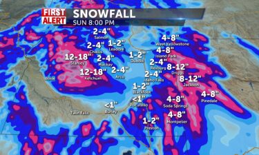
It’s been a fairly gray snowy day and our unsettled weather continues. Several waves of snow with some rain for lower elevations is expected through…
Continue Reading
Southeast Idaho and western Wyoming are gearing up for heavy snow this weekend as winter storms sweep through the…
Continue Reading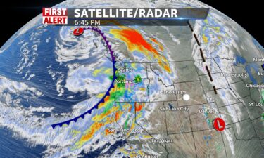
An active pattern continues for eastern Idaho and western Wyoming. We’ll have consistent rain and snow chances each day from now until around Monday…
Continue Reading Big changes in the forecast. After a few smaller storms, we are finally getting a taste of proper winter weather with several storms pushing through.…
Continue Reading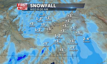
Merry Christmas everyone. Tonight, into tomorrow morning, count on scattered rain and snow showers with most everyone transitioning to snow showers…
Continue Reading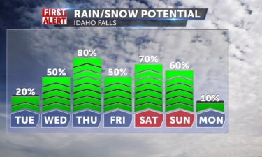
Fresh snow for everyone, though it was warm enough that parts of the Snake River Plain did see a wintery mix at times including a brief period of…
Continue Reading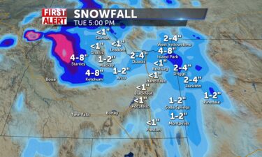
Kicking off an active pattern as we go into Christmas week. Several storms will pass by. Some of them won’t bring a lot of precip. The region, but…
Continue Reading Kicking off an active pattern as we go into Christmas week. Several storms will pass by. Some of them won’t bring a lot of precipitation to the…
Continue Reading
A series of systems are on the way for Christmas week. None of these storms are monsters. …
Continue Reading
It’s looking quiet for a little bit longer, but then a pattern change just in time for Christmas week will kick off a parade of storms that pushes…
Continue Reading
Patchy freezing fog on the start for Thursday with a freezing fog advisory until noon for upper Snake Plain counties. We’ve got temperatures colder…
Continue Reading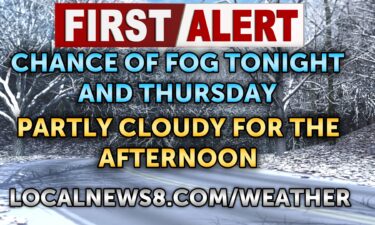
A front is moving through for Wednesday night. We’ll see the winds slowly die down, leading to areas of low clouds and fog for Thursday. Overnight,…
Continue Reading Warmer today with a storm set up to the north, scooting by and leaving us out of the main precip corridor. Winds at 30mph and warm up to the 40’s.…
Continue Reading
Overnight there is a slight chance of snow around midnight. Mostly cloudy, with a low around 27°. South southwest winds around 10…
Continue Reading Winter weather advisories and winter storm warnings for areas east of the interstate into the hills and mountains and western Wyoming counties. Slick…
Continue Reading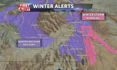
Monday night and early Tuesday, we’ll see snow with some wind. A low temperature in the lower 30’s. Winds from the southwest around 10 to 15 mph,…
Continue Reading
Snow for today with highs hovering around 34. Winds will pick up into tonight with more rounds of snow. Slick conditions are making for road closures…
Continue Reading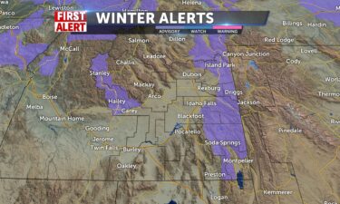
One storm has moved out and another one is moving in. Expect scattered snow showers starting up Monday midday, and continuing through midday Tuesday.…
Continue Reading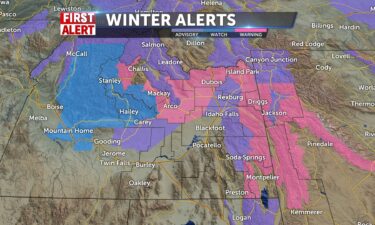
More rain and snow showers headed our way. Most of it will be snow for tonight. The mountains could see several inches of new snow on top of what…
Continue Reading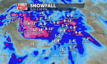
Looks like Jack Frost is finally coming to visit eastern Idaho and western Wyoming. Snow showers will become common with heavy snow likely for higher…
Continue Reading
Most of Idaho highlands are under a Winter Storm Watch through Sunday afternoon. We will see gusty winds to 35mph and snow to 6-12″ for Island Park,…
Continue Reading
Snow showers start today and winds pick up 10-15 with waves of rain/snow for the central valley. Mountain snow may be heavy 6″-12″ and valley…
Continue Reading
For Thursday night we’ll see mostly cloudy skies and a low temperature in the mid 20’s.
There is a slight chance of snow and rain for Friday.…
We’ll lose the high pressure and clouds streaming to start the day with slight shower chances to the north and east of the valley region. More snow…
Continue Reading
A couple of systems are moving into the region. Mostly cloudy overnight, low temperatures around 20°. Scattered rain and snow this…
Continue Reading
We’ll have more clouds today with highs pushing a little warmer to the mid 30’s. N winds 5-10mph and then we prep for another cold front with…
Continue Reading
Mostly clear overnight, with a low around 15°. Chance of fog with light winds from the southwest around 5 mph. Partly sunny for…
Continue Reading
High pressure will slowly push us back to some warmer temps this week. But we start with freezing fog chances and overcast skies this morning with…
Continue Reading
We have a few isolated pockets of snowfall for Monday night, mainly in the mountains east of the Snake River…
Continue Reading Our weather changes due to the front that shuttled through here over the weekend. With a touch of light snow for the valley and 5″ for Jackson ski…
Continue Reading
Our rather unimpressive storm is slowly moving out. We’ll see a few leftover snow flurries in parts of the high country tonight, but most of us will…
Continue Reading
For the past few days, high pressure has been in control. While we have a weak storm tonight and another one in the forecast, neither of them will…
Continue Reading
Saturday, mostly sunny with areas of morning…
Continue Reading
High pressure will relax the hold it has on the region by late Saturday with 20-30mph coming in with a cold front. Light snow and slush expected…
Continue Reading
High pressure remains in place for Friday. Overnight. We’ll see areas of freezing fog with mostly clear…
Continue Reading Today we are still between systems with high pressure on top of the region. Our time is running short though, by this weekend, we’ll have colder air…
Continue Reading
High pressure remains in place through this week. We’ll start to see the high pressure break down over this weekend with a few snow showers…
Continue Reading
Overnight, we’ll see mostly clear skies with a low around 20°. More sunshine for Wednesday with high temps around 40°. Staying sunny for…
Continue Reading High pressure and some calmer than normal airflow, creates a consistent pattern for the rest of the week. We’ve got sunny conditions and cold air on…
Continue Reading
Above normal temps in the forecast this…
Continue Reading High pressure continues to influence our weather for the week after Thanksgiving. Can’t really complain, but seems odd to not have snow on the…
Continue Reading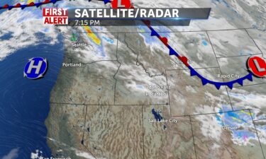
The West is quieting down as high pressure takes control and dominates the forecast. Temperatures will slowly increase with above average highs in…
Continue Reading
Overnight lows around 18° with areas of fog. Mostly cloudy with a slight chance of a snow flurry. Clearing skies for Saturday afternoon with high…
Continue Reading
Chance of fog overnight and staying cold for…
Continue Reading
After Tuesday’s storm, we’re keeping cold temps in the forecast. We’ll also see a few flurries and areas of overnight…
Continue Reading Areas of patchy fog to start then some clearing for traveling to grandma’s house. Freezing temperatures to begin the day and some of those cold temps…
Continue Reading